

You are here
Avalanche Forecast for 2020-12-17 05:30
- EXPIRED ON December 18, 2020 @ 5:30 amPublished on December 17, 2020 @ 5:30 am
- Issued by Aaron Beverly - Mount Shasta Avalanche Center
Bottom Line
Yesterday's storm did not produce the amount of snow expected. Avalanche danger is LOW, though small, isolated wind slabs may exist. Look for them on steep easterly aspects near treeline.


Avalanche Problem 1: Wind Slab
-
Character ?

-
Aspect/Elevation ?
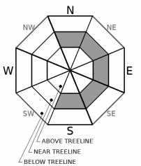
-
Likelihood ?CertainVery LikelyLikelyPossible
 Unlikely
 -
Size ?HistoricVery LargeLargeSmall

Southwest and west winds were productive yesterday and last night during the storm, though the amount of precipitation received was less than expected (3-5 in). You may find small, isolated wind slabs in leeward areas. Look for them on steep easterly aspects near treeline where there was enough prior snow to provide a bed surface for wind slabs to slide on. The east aspect of the ridge up to Gray Butte, where the Gray Butte summer trail leads, would be an area to exercise caution.
Recent Observations
Yesterday's storm was a bust. No weather station in our coverage area is reporting more than 5 inches of new snow. Most are reporting less than 3. The storm started after 2 p.m. with elevations from 5,000 to 6,000 ft receiving more rain than snow. Snow levels came down, though, and elevations above 5,000 ft should have received some snow.
Southwest and west winds were moderate during the bulk of the precipitation, averaging 13 mi/hr, peaking at 22, and gusting up to 49.
For those that may have noticed that our precipitation bucket at the Old Ski Bowl has not been reporting data, we are happy to say that we were able to fix it late last night.
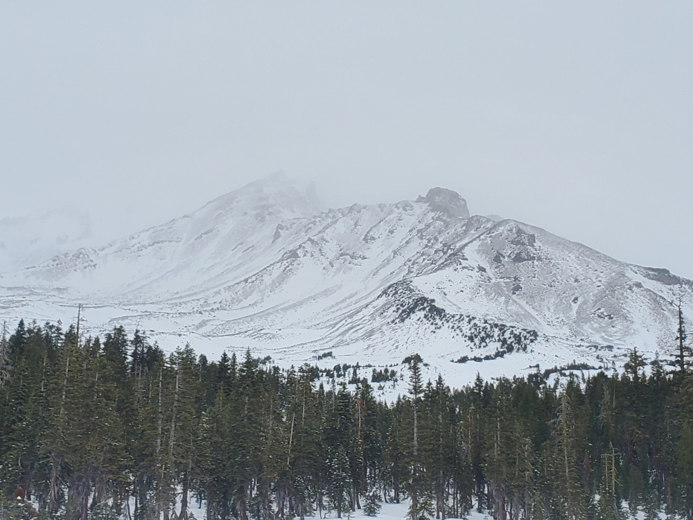
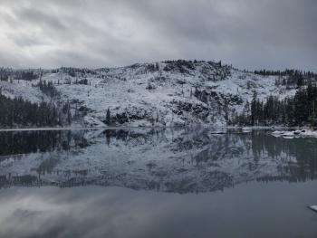
Below is a picture of the upper mountain before yesterday's storm began. Note there is not much coverage. Coverage near and below treeline is much better, near 23 inches in places. Continue to slide and ride with caution. There are hidden hazards below the snow surface.
Weather and Current Conditions
Weather Summary
A cold front moves through today bringing temperatures and snow levels down. Snow showers from the breaking storm may linger until mid-morning, but don't expect much accumulation.
Though things are lining up nicely for the Pacific Northwest with an atmospheric river event scheduled to start Saturday night, it looks as though we'll be just slightly south of the flow. Skunked again!
No notable precipitation is on the radar until Christmas Day.
24 Hour Weather Station Data @ 4:00 AM
| Weather Station | Temp (°F) | Wind (mi/hr) | Snow (in) | Comments | ||||||||
|---|---|---|---|---|---|---|---|---|---|---|---|---|
| Cur | Min | Max | Avg | Avg | Max Gust | Dir | Depth | New | Water Equivalent | Settlement | ||
| Mt. Shasta City (3540 ft) | 33 | 28 | 45 | 34.5 | 1 | N | ||||||
| Sand Flat (6750 ft) | 28 | 27 | 34 | 30 | Not reporting accurate snow depth and SWE | |||||||
| Ski Bowl (7600 ft) | 22.5 | 22.5 | 33.5 | 28.5 | 23.2 | 4.7 | 0.31 | 0 | ||||
| Gray Butte (8000 ft) | 21 | 21 | 34 | 27 | 14 | 49 | WSW | |||||
| Castle Lake (5870 ft) | 27.5 | 26.5 | 35.5 | 30 | 5.3 | 1.4 | 0 | |||||
| Mount Eddy (6509 ft) | 26 | 26 | 39 | 31.5 | 1 | 5 | 13.2 | 1.7 | 0 | |||
| Ash Creek Bowl (7250 ft) | 24.5 | 24.5 | 36 | 29 | 23.9 | 2.7 | 0 | |||||
| Ash Creek Ridge (7895 ft) | 21 | 21 | 34.5 | 26.5 |
Two Day Mountain Weather Forecast
Produced in partnership with the Medford NWS
| For 7000 ft to 9000 ft | |||
|---|---|---|---|
|
Thursday (4 a.m. to 10 p.m.) |
Thursday Night (10 p.m. to 4 a.m.) |
Friday (4 a.m. to 10 p.m.) |
|
| Weather | A 30 percent chance of snow before 10 a.m. Partly sunny. | Partly cloudy. | Partly sunny. |
| Temperature (°F) | 29 | 27 | 36 |
| Wind (mi/hr) | Northwest 5-10 | North 5-10 | North 5-10 |
| Precipitation SWE / Snowfall (in) | 0.03 / 0-0.50 | 0.00 / 0 | 0.00 / 0 |
| For 9000 ft to 11000 ft | |||
| Thursday | Thursday Night | Friday | |
| Weather | A 40 percent chance of snow before 10 a.m. Partly sunny. Windy. Low wind chills. | Partly cloudy. Windy. Low wind chills. | Mostly sunny. Windy. Low wind chills. |
| Temperature (°F) | 23 | 23 | 30 |
| Wind (mi/hr) | Northwest 20-25 | North 25-30 | Northwest 25-30 |
| Precipitation SWE / Snowfall (in) | 0.03 / 0-0.50 | 0.00 / 0 | 0.00 / 0 |
Season Precipitation for Mount Shasta City
| Period | Measured (in) | Normal (in) | Percent of Normal (%) |
|---|---|---|---|
| From Oct 1, 2025 (the wet season) | 2.25 | 11.20 | 20 |
| Month to Date (since Jun 1, 2026) | 0.55 | 3.84 | 14 |
| Year to Date (since Jan 1, 2026) | 15.16 | 39.20 | 39 |

