

You are here
Avalanche Forecast for 2020-12-20 06:50
- EXPIRED ON December 21, 2020 @ 6:50 amPublished on December 20, 2020 @ 6:50 am
- Issued by Ryan Sorenson - Mount Shasta Avalanche Center
Bottom Line
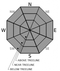
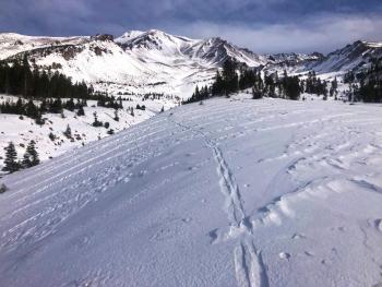
A northwest wind event has scoured and sublimated most of the snowpack on Mount Shasta. Thin gullies of chalky wind pressed snow remain above treeline. Below and near treeline is holding the best coverage with one to two feet of variable surface textures. Use caution. Many obstacles are barely hidden. Avalanche danger is LOW at all elevations.


Avalanche Problem 1: Normal Caution
-
Character ?

-
Aspect/Elevation ?
-
Likelihood ?CertainVery LikelyLikelyPossible
 Unlikely
 -
Size ?HistoricVery LargeLargeSmall

Normal caution with low avalanche danger continues. Northwest winds have scoured away most of the remaining snow and little to no snow is left on the typical avalanche starting zones. Firm, chalky pressed snow remains in the low angle gully systems. Watch out for many hidden and not-so-hidden obstacles. Keep practicing your avalanche rescue skills and identifying potential avalanche terrain.
Forecast Discussion
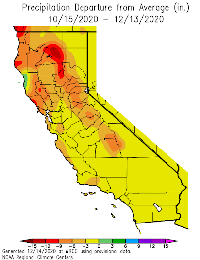
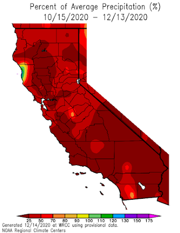
It has been extremely dry for the last two months. Below is a look at how precipitation over California differs from normal for October through December. Much of California has received 50 to 25% of the precipitation it typically gets during this time of year. Many Northern California regions are off 5 to 15 inches from normal.
Recent Observations
- Mount Shasta has received strong northwest winds this weekend.
- 35 hours of winds speeds over 15 mi/hr have been recorded at 8,000 feet on Gray Butte (3 pm Dec 18th - 5 AM Dec 20)
- Our thin snowpack has been scoured and large rocky patches are now showing.
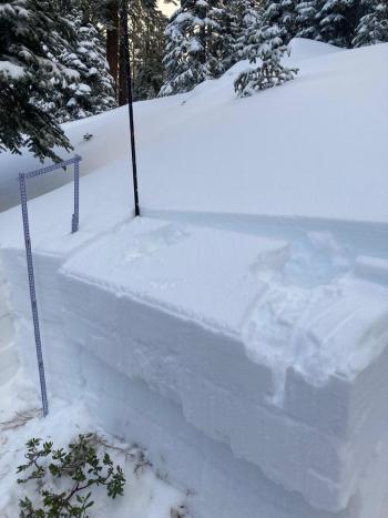
- East of the mountain, areas such as Ash Creek Butte and the Northeast Crest hold the deepest snowpack. Average depth is two feet.
- Protected pockets of soft snow remain near and below treeline on northerly and/or other shaded/sheltered aspects. Variable crusts exist everywhere.
- Winds have ranged from 19 to 32 mi/hr gusting as high as 55 mi/hr over the last 24 hours.
- Temps have ranged from 33 to 41 deg F at 8,000 feet.

Weather and Current Conditions
Weather Summary
Expect a break in the weather this morning as a ridge of pressure in the upper atmosphere hits the strong winds' pause button. Sunny skies will allow temperatures to rise to the mid 40's F today. The action will return this afternoon as winds switch to southerly, signaling an approaching storm north of our reach. Tomorrow afternoon, we will catch a wisp of moisture bunted our way as the Pacific Northwest scores a solid base hit. A half-inch of snow is possible with snow levels near 4,900 feet. Get out of your seats and do a snow dance, folks. It's looking high and dry, and we could really use some moisture.
24 Hour Weather Station Data @ 6:00 AM
| Weather Station | Temp (°F) | Wind (mi/hr) | Snow (in) | Comments | ||||||||
|---|---|---|---|---|---|---|---|---|---|---|---|---|
| Cur | Min | Max | Avg | Avg | Max Gust | Dir | Depth | New | Water Equivalent | Settlement | ||
| Mt. Shasta City (3540 ft) | 30 | 24 | 44 | 34 | 1 | N | ||||||
| Sand Flat (6750 ft) | 40 | 27 | 42 | 37 | State station; Not reporting accurate snow depth and SWE | |||||||
| Ski Bowl (7600 ft) | 40 | 37 | 42.5 | 40.5 | 21.5 | 0 | 0 | 0.3 | ||||
| Gray Butte (8000 ft) | 39 | 33 | 40 | 37 | 24 | 55 | NW | |||||
| Castle Lake (5870 ft) | 42.5 | 33 | 43 | 38.5 | 6.9 | 0 | 0 | |||||
| Mount Eddy (6509 ft) | 40 | 27 | 44.5 | 37.5 | 2 | 8 | WSW | 15.7 | 0 | 0.8 | ||
| Ash Creek Bowl (7250 ft) | 36.5 | 28 | 39.5 | 34 | 22.8 | 0 | 0.4 | |||||
| Ash Creek Ridge (7895 ft) | 36.5 | 26 | 37 | 33 | 0 | 0 | N |
Two Day Mountain Weather Forecast
Produced in partnership with the Medford NWS
| For 7000 ft to 9000 ft | |||
|---|---|---|---|
|
Sunday (4 a.m. to 10 p.m.) |
Sunday Night (10 p.m. to 4 a.m.) |
Monday (4 a.m. to 10 p.m.) |
|
| Weather | Partly cloudy in morning, becoming mostly sunny. | Partly cloudy. | Partly cloudy, breezy. Chance of snow in the afternoon. |
| Temperature (°F) | 46 | 33 | 44 |
| Wind (mi/hr) | West 5-10 | West 5-10 | South 10-15 |
| Precipitation SWE / Snowfall (in) | 0.00 / 0-0.50 | 0.00 / 0 | 0.04 / 0-0.50 |
| For 9000 ft to 11000 ft | |||
| Sunday | Sunday Night | Monday | |
| Weather | Partly cloudy in morning, becoming mostly sunny. Breezy. | Partly cloudy. | Partly cloudy, breezy. Chance of snow in the afternoon. |
| Temperature (°F) | 36 | 35 | 35 |
| Wind (mi/hr) | West 20-25 | West 15-25 | Southwest 25-35 |
| Precipitation SWE / Snowfall (in) | 0.00 / 0-0.50 | 0.00 / 0 | 0.04 / 0-0.50 |
Season Precipitation for Mount Shasta City
| Period | Measured (in) | Normal (in) | Percent of Normal (%) |
|---|---|---|---|
| From Oct 1, 2025 (the wet season) | 2.30 | 12.04 | 19 |
| Month to Date (since Jun 1, 2026) | 0.60 | 4.68 | 13 |
| Year to Date (since Jan 1, 2026) | 15.21 | 40.04 | 38 |

