

You are here
Avalanche Forecast for 2020-12-25 06:30
- EXPIRED ON December 26, 2020 @ 6:30 amPublished on December 25, 2020 @ 6:30 am
- Issued by Aaron Beverly - Mount Shasta Avalanche Center
Bottom Line
Avalanche danger is moderate. Human triggered wind slab and storm slab avalanches are possible. Look for these problems primarily near and below treeline. Today's forecasted storm numbers are a bit uncertain, but we are thinking up to 15 inches above 3,500 ft.


Avalanche Problem 1: Wind Slab
-
Character ?

-
Aspect/Elevation ?
-
Likelihood ?CertainVery LikelyLikelyPossible
 Unlikely
 -
Size ?HistoricVery LargeLargeSmall

If you're out rescuing reindeer from the Abominable Snow Bumble today, you better get into the avalanche mindset. Pay attention. How much snow is accumulating and where is it blowing? Identify areas of concern. Are you hearing whumphing or seeing shooting cracks or blocking snow? These are signs that wind slabs are forming. Evaluate terrain carefully. Steep leeward slopes over 30 degrees will be suspect.
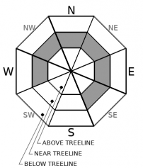
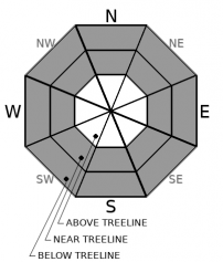
Wind slabs will be mostly a near treeline issue today as there just isn't much snow above treeline to provide a bed surface for snow to slide on. Hidden rocks will be more of a concern. But there is always a bit of ambiguity where near treeline and above treeline terrain exists. So pay attention where ever you are.
Avalanche Problem 2: Storm Slab
-
Character ?

-
Aspect/Elevation ?
-
Likelihood ?CertainVery LikelyLikelyPossible
Unlikely
-
Size ?HistoricVery LargeLargeSmall
A storm slab avalanche is a release of a soft cohesive layer of new snow that breaks within the storm snow or on the old snow surface. Storm-slab problems typically last between a few hours and few days. With well over a foot of snow expected in 24 hours and changing temperatures, I would definitely add this to my list of concerns today.
Look for this problem on slopes over 35 degrees. The west facing chutes on Gray Butte and the backside of Coyote Butte at the Mount Shasta Ski Park are areas I think of as being near or below treeline and capable of producing storm slab avalanches.
Forecast Discussion
Merry Christmas from your friends at the Mount Shasta Avalanche Center. We are stoked for today's storm and the opportunity to talk about avalanches again!
The Mount Shasta Ski Park is scheduled to open Saturday and the Mount Shasta Nordic Center, Sunday. As the storm breaks tomorrow, it'll be the day to get out. If you've been complacent about your avalanche rescue gear, now is the time to get that shovel, probe, and transceiver ready. Have fun!
Recent Observations
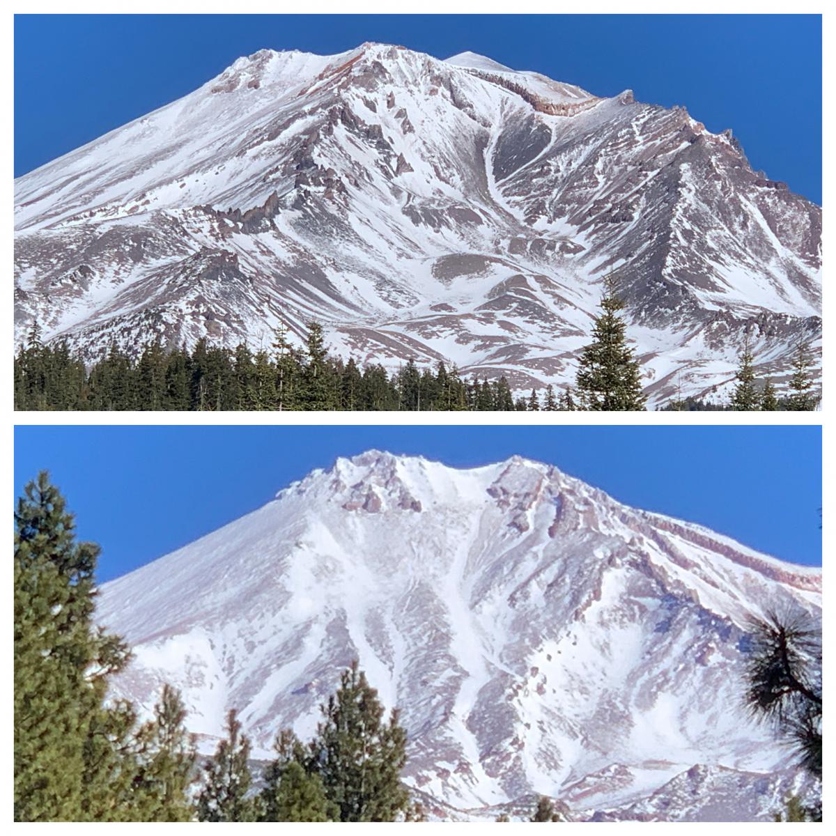
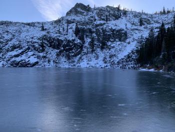
Snow depth averages 0-24 inches across the forecast area. The best coverage on the mountain remains below and near treeline. Gray Butte and Ash Creek Butte still hold enough snow to provide bed surfaces for new snow to slide on, but incessant wind from all directions has scoured above treeline terrain quite well. See photo below.
We've found a few areas on northerly aspects hosting weak layers of sugary snow mid-way down in the shallow snowpack. Avalanche starting zones are overwhelmingly devoid of snow making these layers a low concern at this time.
Weather and Current Conditions
Weather Summary
A winter storm warning is in effect above 3,000 ft from 10 a.m. today to 10 a.m. tomorrow.
There is a bit of uncertainty in numbers for our Christmas Day storm. Point forecasts indicate up to 32 inches of snow at high elevations. But only a little over an inch of precipitable water is available in the atmosphere. This translates to 6-15 inches of snow. Snow levels are predicted to be 2,500 - 3,500 ft, though forecasted temperatures indicate levels might be much higher than this to start. Suffice to say, we are going to get some good snow out of this at elevations where we want to see it and south/southwest winds are gonna be strong to gale force. Fasten your seatbelts, its going to be a bumpy night.
More snow is on the way mid next week with an atmospheric river event scheduled to start Tuesday night.
24 Hour Weather Station Data @ 6:00 AM
| Weather Station | Temp (°F) | Wind (mi/hr) | Snow (in) | Comments | ||||||||
|---|---|---|---|---|---|---|---|---|---|---|---|---|
| Cur | Min | Max | Avg | Avg | Max Gust | Dir | Depth | New | Water Equivalent | Settlement | ||
| Mt. Shasta City (3540 ft) | 41 | 22 | 51 | 40 | 2 | N | ||||||
| Sand Flat (6750 ft) | 29 | 29 | 43 | 34 | 23 | 0 | 0 | 1 | Snow depth measured by hand. Depth sensor not working. | |||
| Ski Bowl (7600 ft) | 24.5 | 24.5 | 41 | 32 | 20.3 | 0.4 | 0.02 | 0 | ||||
| Gray Butte (8000 ft) | 21 | 21 | 37.5 | 29.5 | 9 | 43 | WSW | |||||
| Castle Lake (5870 ft) | 29.5 | 27.5 | 41.5 | 33.5 | 6.6 | 0 | 0.4 | |||||
| Mount Eddy (6509 ft) | 29 | 28 | 40 | 33.5 | 2 | 5 | SSW | 15.9 | 0.5 | 0 | ||
| Ash Creek Bowl (7250 ft) | 24.5 | 24.5 | 37 | 31 | 22.2 | 0 | 0.7 | |||||
| Ash Creek Ridge (7895 ft) | 20 | 19.5 | 34 | 27.5 |
Two Day Mountain Weather Forecast
Produced in partnership with the Medford NWS
| For 7000 ft to 9000 ft | |||
|---|---|---|---|
|
Friday (4 a.m. to 10 p.m.) |
Friday Night (10 p.m. to 4 a.m.) |
Saturday (4 a.m. to 10 p.m.) |
|
| Weather | Snow, mainly after 10 a.m. The snow could be heavy at times. Areas of blowing snow after 10 a.m. Windy. Chance of precipitation is 80%. | Snow. The snow could be heavy at times. Patchy blowing snow before 10 p.m. Windy. Chance of precipitation is 100%. | Snow, mainly before 10 a.m. Chance of precipitation is 80%. |
| Temperature (°F) | 29 | 25 | 29 |
| Wind (mi/hr) | South 25-30 | South 20-25 | Southwest 10-15 |
| Precipitation SWE / Snowfall (in) | 0.75 / 4-8 | 0.23 / 1-3 | 0.18 / 1-2 |
| For 9000 ft to 11000 ft | |||
| Friday | Friday Night | Saturday | |
| Weather | Snow, mainly after 7 a.m. The snow could be heavy at times. Widespread blowing snow, mainly after 10 a.m. Windy. Low wind chills. Chance of precipitation is 80%. | Snow. The snow could be heavy at times. Widespread blowing snow, mainly before 10 p.m. Windy. Low wind chills. Chance of precipitation is 100%. | Snow, mainly before 1 p.m. Areas of blowing snow. Windy. Low wind chills. Chance of precipitation is 80%. |
| Temperature (°F) | 26 | 15 | 17 |
| Wind (mi/hr) | South 60-70 | Southwest 60-70 | West 35-40 |
| Precipitation SWE / Snowfall (in) | 0.75 / 4-8 | 0.23 / 2-4 | 0.18 / 2-3 |
Season Precipitation for Mount Shasta City
| Period | Measured (in) | Normal (in) | Percent of Normal (%) |
|---|---|---|---|
| From Oct 1, 2025 (the wet season) | 2.42 | 13.41 | 18 |
| Month to Date (since Jun 1, 2026) | 0.72 | 6.05 | 12 |
| Year to Date (since Jan 1, 2026) | 15.33 | 41.41 | 37 |

