

You are here
Avalanche Forecast for 2020-12-26 06:55
- EXPIRED ON December 27, 2020 @ 6:55 amPublished on December 26, 2020 @ 6:55 am
- Issued by Ryan Sorenson - Mount Shasta Avalanche Center
Bottom Line
The Christmas storm brought 14 inches of fresh snow and productive southwesterly winds. Human-triggered wind slab avalanches are possible today. Look for unstable snow on areas that previously held a snowpack.


Avalanche Problem 1: Wind Slab
-
Character ?

-
Aspect/Elevation ?
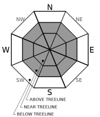
-
Likelihood ?CertainVery LikelyLikelyPossible
 Unlikely
 -
Size ?HistoricVery LargeLargeSmall

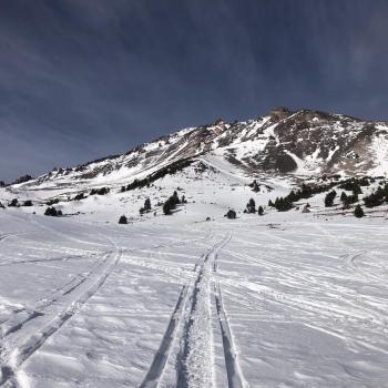
Productive winds out of the west and south have been recorded on Gray Butte throughout the Christmas storm. Winds out of the south and east were observed during a tour on Green Butte. Expect winds to continue to blow the 14 inches of snow accumulated on Mount Shasta into fresh wind slabs. Wind slabs that form in areas that previously held a deep enough snowpack to provide a bed surface will be most suspect. These predominantly lie in near treeline terrain. Above treeline terrain could host a wind slab problem though a level of uncertainty remains due to the lack of pre-existing snow; however, you should always pay attention when traveling in avalanche terrain.
Stay in the avalanche mindset. Identify where wind slabs may exist by paying attention to clues like blowing snow, cornices above a slope, snowdrifts, and wind created surface textures. Shooting cracks, blocking, and hollow sounding snow are signs that wind slabs may be reactive to a human trigger. Adjust travel plans to minimize exposure to potential wind slabs.
Forecast Discussion
Storm slab avalanche problems tend to be short-lived but continue to pay attention to slopes greater than 35 degrees. Storm slabs avalanches occur when a cohesive layer of snow releases within the new snow or at the old snow interface. Temperature changes during a storm often create the right conditions for these slabs to form.
It's on, excitement is high, and the fresh snow has fallen. Don't let the excitement of the first significant storm cloud your judgment of avalanche danger.
The 5 RED FLAGS of avalanche danger are true anywhere you have steep mountains and snow on the ground. Engrave them into your brain:
1- Recent Avalanches: If there are new avalanches, more are possible.
2- Signs of Unstable Snow: Shooting cracks, collapsing or whumpfing noises, or hollow drum-like sounds.
3- Heavy Snowfall or Rain: Recent significant snowfall or rain can make the snowpack unstable. Avalanches are often triggered immediately during or just after a storm.
4-Wind Drifting: Wind blown snow can load slopes even when it's not snowing.
5- Rapid Warming: Warm temperatures can cause snow to become saturated and less stable
The Mount Shasta Ski Park is scheduled to open today, and the Mount Shasta Nordic Center, Sunday.
Recent Observations
Consistent precipitation has occurred on Mount Shasta since 9 a.m. yesterday. Our weather station at Old Ski Bowl has recorded 14 inches of new snow (0.86 SWE) in the last 24 hours. Wind speeds on Gray Butte have averaged 17 mi/hr maxing out a 21 mi/ hr with gusts as high as 43 mi/hr. The Eddies and Ash Creek Butte have received 7 to 10 inches of new snow.
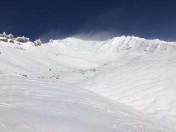
Our snowpack was shallow before this storm. Incessant wind from all directions scoured above treeline terrain, leaving most avalanche starting zones without snow. Areas that come to mind that may host enough snow to provide bed surfaces include Gray Butte and Ash Creek Butte. Near and below treeline terrain held up to two feet of crusty old snow. A few areas on protected northerly aspects may host weak layers of sugary snow mixed mid-way down in snowpack.
Weather and Current Conditions
Weather Summary
The Christmas Day storm will fade off this morning. There is a chance of lingering showers, but the main action will end before 10 a.m. Winds will begin to calm down as well. Then we will have mostly cloudy skies through Monday. Expect temperatures to remain cool with highs in the low 30s F. Temperatures at upper elevations will remain in the teens.
More snow is on the way, with an atmospheric river event scheduled to start Tuesday night.
24 Hour Weather Station Data @ 6:00 AM
| Weather Station | Temp (°F) | Wind (mi/hr) | Snow (in) | Comments | ||||||||
|---|---|---|---|---|---|---|---|---|---|---|---|---|
| Cur | Min | Max | Avg | Avg | Max Gust | Dir | Depth | New | Water Equivalent | Settlement | ||
| Mt. Shasta City (3540 ft) | 36 | 32 | 40 | 34 | 4 | E | ||||||
| Sand Flat (6750 ft) | 27 | 25 | 29 | 27 | 0 | 0 | 0 | 0 | Depth sensor not working. | |||
| Ski Bowl (7600 ft) | 22.5 | 20.5 | 24.5 | 23 | 34.8 | 14.2 | 0.87 | 0 | ||||
| Gray Butte (8000 ft) | 22 | 19 | 24 | 21.5 | 17 | 43 | S | |||||
| Castle Lake (5870 ft) | 27.5 | 24 | 29.5 | 26.5 | 13.6 | 7.2 | 0 | |||||
| Mount Eddy (6509 ft) | 25.5 | 23 | 29 | 26 | 2 | 7 | SSW | 26.5 | 10.2 | 0 | ||
| Ash Creek Bowl (7250 ft) | 24 | 20.5 | 26 | 23.5 | 29.6 | 7.4 | 0 | |||||
| Ash Creek Ridge (7895 ft) | 20.5 | 17 | 23 | 20 | 0 | 0 | N |
Two Day Mountain Weather Forecast
Produced in partnership with the Medford NWS
| For 7000 ft to 9000 ft | |||
|---|---|---|---|
|
Saturday (4 a.m. to 10 p.m.) |
Saturday Night (10 p.m. to 4 a.m.) |
Sunday (4 a.m. to 10 p.m.) |
|
| Weather | Mostly cloudy. Snow in the morning, then chance of snow in the afternoon. Snow levels 2500-3,500 feet. | Mostly cloudy. | Mostly cloudy. |
| Temperature (°F) | 31 | 20 | 31 |
| Wind (mi/hr) | Southwest 10-15 | Southeast 5-10 | East 5-10 |
| Precipitation SWE / Snowfall (in) | 0.14 / 1-2 | 0.00 / 0 | 0.00 / 0 |
| For 9000 ft to 11000 ft | |||
| Saturday | Saturday Night | Sunday | |
| Weather | Mostly cloudy. Snow in the morning, then chance of snow in the afternoon. Snow levels 2500-3,500 feet. | Mostly cloudy. | Mostly cloudy. |
| Temperature (°F) | 17 | 16 | 16 |
| Wind (mi/hr) | West 30-35 | Northwest 15-20 | South 15-20 |
| Precipitation SWE / Snowfall (in) | 0.14 / 1-2 | 0.00 / 0 | 0.00 / 0 |
Season Precipitation for Mount Shasta City
| Period | Measured (in) | Normal (in) | Percent of Normal (%) |
|---|---|---|---|
| From Oct 1, 2025 (the wet season) | 3.39 | 13.67 | 25 |
| Month to Date (since Jul 1, 2026) | 1.69 | 6.31 | 27 |
| Year to Date (since Jan 1, 2026) | 16.30 | 41.67 | 39 |

