

You are here
Avalanche Forecast for 2020-12-28 06:45
- EXPIRED ON December 29, 2020 @ 6:45 amPublished on December 28, 2020 @ 6:45 am
- Issued by Ryan Sorenson - Mount Shasta Avalanche Center
Bottom Line
Avalanche danger is LOW. Light snow from a Christmas storm sits over a shallow snowpack. Continue to watch for unstable snow on isolated steep areas that previously held a deeper snowpack. Many hidden obstacles, such as rocks, logs and bushes remain.


Avalanche Problem 1: Normal Caution
-
Character ?

Avalanche danger is LOW, but continue to be attentive in examining the terrain, weather, snowpack, and human factors involved in traveling safely in the backcountry. Rember, in 90 percent of avalanche incidents, the avalanche is triggered by the weight of the victim or someone in the victim's party. Be aware of how your decisions impact you and your group as you travel in and near avalanche terrain. Consider creating a team approach, where all the party members are responsible for one another's safety.
Always be on the lookout for the five red flags of avalanche danger:
- Recent Avalanches: If there are new avalanches, more are possible.
- Signs of Unstable Snow: Shooting cracks, collapsing or whumpfing noises, or hollow drum-like sounds.
- Heavy Snowfall or Rain: Recent significant snowfall or rain can make the snowpack unstable. Avalanches are often triggered immediately during or just after a storm.
- Wind Drifting: Wind blown snow can load slopes even when it's not snowing.
- Rapid Warming: Warm temperatures can cause snow to become saturated and less stable.
Forecast Discussion
We respectfully request that 4-wheeling enthusiasts refrain from using lower Sand Flat road. Thank you.
Recent Observations
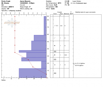
The 14 (0.96 SWE) inches of snow received on Christmas has mostly remained in place due to cool temperatures and light winds. Some wind effect does exist at upper elevations and exposed ridges through no major wind slab formation has been observed. South-facing slopes below treeline are beginning to form a zipper thin melt-freeze crust on the surface. The fresh snow sits over a shallow snowpack. An average snow depth of 31 inches was measured at Horse Camp, 7,950 feet yesterday. Protected areas near treeline host weak layers of sugary snow mixed with crusts in the old snow. There have been some reports of whumpfing and shooting cracks near our forecast area, northwest of the Parks Creek drainage. Similar layers likely caused this; further investigation to follow.
In the last 24 hours, winds on Gray Butte have been out of the east, averaging 21 mi/hr and maxing out at 29 mi/ hr with gusts to 49 mi/hr. Temperatures have ranged from 18 ℉ to 29.5 ℉.

Weather and Current Conditions
Weather Summary
Similar to yesterday, we will have partly cloudy skies in the morning then sunny conditions. Expect temperatures to stay cool with highs in the low 30s F. Temperatures at upper elevations will remain in the teens to low 20s. Winds will be light out of the northeast. A temperature inversion will allow fog to linger in the Shasta valley.
We will have snow on Wednesday as a storm skips by us to the north. Only a few inches is expected. However, this storm sets the stage for a series of promising storms in early January.
24 Hour Weather Station Data @ 6:00 AM
| Weather Station | Temp (°F) | Wind (mi/hr) | Snow (in) | Comments | ||||||||
|---|---|---|---|---|---|---|---|---|---|---|---|---|
| Cur | Min | Max | Avg | Avg | Max Gust | Dir | Depth | New | Water Equivalent | Settlement | ||
| Mt. Shasta City (3540 ft) | 24 | 24 | 41 | 29.5 | 1 | N | ||||||
| Sand Flat (6750 ft) | 22 | 17 | 32 | 23 | Depth sensor not working. | |||||||
| Ski Bowl (7600 ft) | 20.5 | 20 | 32 | 24.5 | 30.7 | 0 | 0 | 2.9 | ||||
| Gray Butte (8000 ft) | 18 | 18 | 29.5 | 22.5 | 19 | 49 | E | |||||
| Castle Lake (5870 ft) | 23.5 | 23.5 | 29.5 | 26 | 13.6 | 0 | 0 | |||||
| Mount Eddy (6509 ft) | 19 | 19 | 30 | 23 | 2 | 4 | WSW | 27.3 | 0 | 0 | ||
| Ash Creek Bowl (7250 ft) | 21 | 20.5 | 28.5 | 23.5 | 29.4 | 0 | 1 | |||||
| Ash Creek Ridge (7895 ft) | 16.5 | 15 | 24.5 | 18.5 | 0 | 0 | N |
Two Day Mountain Weather Forecast
Produced in partnership with the Medford NWS
| For 7000 ft to 9000 ft | |||
|---|---|---|---|
|
Monday (4 a.m. to 10 p.m.) |
Monday Night (10 p.m. to 4 a.m.) |
Tuesday (4 a.m. to 10 p.m.) |
|
| Weather | Partly cloudy this morning then becoming sunny. | Mostly clear. | Sunny in the morning then becoming partly cloudy. |
| Temperature (°F) | 32 | 18 | 31 |
| Wind (mi/hr) | Northeast 5-10 | Northeast 5-10 | North 5-10 |
| Precipitation SWE / Snowfall (in) | 0.00 / 0 | 0.00 / 0 | 0.00 / 0 |
| For 9000 ft to 11000 ft | |||
| Monday | Monday Night | Tuesday | |
| Weather | Partly cloudy, becoming sunny. | Clear. | Sunny in the morning then becoming partly cloudy. |
| Temperature (°F) | 18 | 18 | 24 |
| Wind (mi/hr) | East 20-25 | Northeast 25-30 | Northwest 20-25 |
| Precipitation SWE / Snowfall (in) | 0.00 / 0 | 0.00 / 0 | 0.00 / 0 |
Season Precipitation for Mount Shasta City
| Period | Measured (in) | Normal (in) | Percent of Normal (%) |
|---|---|---|---|
| From Oct 1, 2025 (the wet season) | 3.49 | 14.19 | 25 |
| Month to Date (since Jun 1, 2026) | 1.79 | 6.83 | 26 |
| Year to Date (since Jan 1, 2026) | 16.40 | 42.19 | 39 |

