

You are here
Avalanche Forecast for 2020-12-29 06:30
- EXPIRED ON December 30, 2020 @ 6:30 amPublished on December 29, 2020 @ 6:30 am
- Issued by Aaron Beverly - Mount Shasta Avalanche Center
Bottom Line
Overall avalanche danger is low. Hidden rocks will continue to present a hazard to sliders and riders. Some remote, cold areas on the fringes of our forecast area show signs of a persistent weak layer. A small storm should bring 3-4 inches of snow tomorrow night.


Avalanche Problem 1: Normal Caution
-
Character ?

-
Aspect/Elevation ?
-
Likelihood ?CertainVery LikelyLikelyPossible
 Unlikely
Overall avalanche danger is low. But low danger does not mean no danger. As winds pick up, look for new wind slabs forming in isolated areas. If you see snow being transported, pay attention near steep leeward slopes. Shooting cracks or whumphing sounds indicate instabilities lie within the snowpack.
Forecast Discussion
A persistent weak layer exists in some of our colder, north facing, remote zones. If you find yourself venturing far out into the boonies (Park's Creek, Ash Creek Butte, and the eastern crest), take some extra time to do some sleuthing. Whumphing sounds indicate the snowpack is collapsing within a weak layer and is one of our obvious signs of avalanche danger. Don't ignore it.
Recent Observations
You'll find up to 30 inches of snow in more sheltered areas throughout our forecast area.
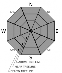
Above treeline, soft chalky, wind-affected snow will be found with gullies holding the most. Tread lightly, though, as there are hidden rocks lurking. Avoid the sides of ridges if you value the bases of your skis or the function of your knees. Snowmobilers should be extra careful everywhere off the roads.
Near and below treeline, zipper crusts had started to form near and below treeline Sunday in areas exposed to direct sun, but temperatures have stayed below freezing and there is still plenty of light, soft snow out there.
East/northeast winds kicked up last night averaging 18 mi/hr.
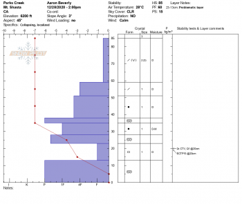
In the Park's Creek area, widespread hoar frost was seen. Spine tingling whumphs were felt and column tests indicated notable failures in a persistent, faceted layer about 2 feet down. This concern is localized to some of our remote areas that tend to stay cold. This problem has not been seen on Mount Shasta. See today's observation for details.

Weather and Current Conditions
Weather Summary
A high pressure ridge will keep things sunny and dry today. It'll begin breaking down tonight setting us up to receive some precipitation tomorrow evening. We could get up to 4 inches at elevations above 3,500 ft.
A period of wetter weather is in store for us beginning this weekend.
24 Hour Weather Station Data @ 5:00 AM
| Weather Station | Temp (°F) | Wind (mi/hr) | Snow (in) | Comments | ||||||||
|---|---|---|---|---|---|---|---|---|---|---|---|---|
| Cur | Min | Max | Avg | Avg | Max Gust | Dir | Depth | New | Water Equivalent | Settlement | ||
| Mt. Shasta City (3540 ft) | 21 | 21 | 38 | 30.5 | 2 | N | ||||||
| Sand Flat (6750 ft) | 16 | 15 | 29 | 22 | 0 | 0 | Depth sensor not working. | |||||
| Ski Bowl (7600 ft) | 31 | 19.5 | 33 | 25.5 | 28.2 | 0 | 0 | 2.2 | ||||
| Gray Butte (8000 ft) | 31.5 | 18.5 | 31.5 | 24.5 | 18 | 49 | ENE | |||||
| Castle Lake (5870 ft) | 28 | 22.5 | 28 | 24.5 | 13.4 | 0 | 0.2 | |||||
| Mount Eddy (6509 ft) | 27 | 21 | 29.5 | 25.5 | 2 | 6 | SW | 27 | 0.2 | 0 | ||
| Ash Creek Bowl (7250 ft) | 23 | 15 | 25.5 | 20.5 | 29.1 | 0 | 0.2 | |||||
| Ash Creek Ridge (7895 ft) | 23.5 | 14.5 | 27.5 | 19 | 0 | 0 | N |
Two Day Mountain Weather Forecast
Produced in partnership with the Medford NWS
| For 7000 ft to 9000 ft | |||
|---|---|---|---|
|
Tuesday (4 a.m. to 10 p.m.) |
Tuesday Night (10 p.m. to 4 a.m.) |
Wednesday (4 a.m. to 10 p.m.) |
|
| Weather | Sunny. | Increasing clouds. | Increasing clouds. A 30 percent chance of snow after 10 a.m. |
| Temperature (°F) | 38 | 26 | 35 |
| Wind (mi/hr) | Northwest 5-10 | Southwest 5-10 | South 5-10 |
| Precipitation SWE / Snowfall (in) | 0.00 / 0 | 0.00 / 0 | 0.20 / 1-2 |
| For 9000 ft to 11000 ft | |||
| Tuesday | Tuesday Night | Wednesday | |
| Weather | Sunny. Breezy. | Increasing clouds. Breezy. | 80% chance of snow, mainly after 4 p.m. Windy. Low wind chills. |
| Temperature (°F) | 26 | 15 | 23 |
| Wind (mi/hr) | Northwest 15-20 | West 20-25 | West 40-50 |
| Precipitation SWE / Snowfall (in) | 0.00 / 0 | 0.00 / 0 | 0.20 / 1-2 |
Season Precipitation for Mount Shasta City
| Period | Measured (in) | Normal (in) | Percent of Normal (%) |
|---|---|---|---|
| From Oct 1, 2025 (the wet season) | 3.49 | 14.45 | 24 |
| Month to Date (since Jun 1, 2026) | 1.79 | 7.09 | 25 |
| Year to Date (since Jan 1, 2026) | 16.40 | 42.45 | 39 |

