

You are here
Avalanche Forecast for 2020-12-31 05:22
- EXPIRED ON January 1, 2021 @ 5:22 amPublished on December 31, 2020 @ 5:22 am
- Issued by Nick Meyers - Shasta-Trinity National Forest
Bottom Line
Last night, 2 - 3 inches of new snow fell and paired with moderate west/northwest wind. The avalanche danger will remain low and normal caution is advised. Watch for blowing snow and small wind slabs in isolated areas or extreme terrain. Earthly hazards still lurk below the snow surface in many areas. Shred lightly.


Avalanche Problem 1: Normal Caution
-
Character ?

-
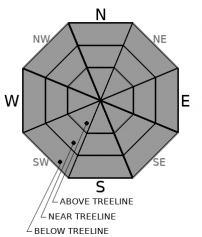
Aspect/Elevation ?
-
Likelihood ?CertainVery LikelyLikelyPossible
 Unlikely
With a couple inches of fresh snow and northwesterly wind, watch for wind blowing snow near avalanche terrain. A few small wind slabs might be encountered in isolated terrain. None of these are expected to be of significant size. New snow above treeline could be swept away already. Near and below treeline and/or above treeline gully systems might hold the best and "deepest" new snow. Overall, natural and human triggered avalanches of consequence are unlikely today. With several storms knocking at the door, anticipate changing conditions over the next week.
Recognizing avalanche terrain is one of the most important topics to learn about when it comes to staying safe in the backcountry. Have a look at this short video.
Forecast Discussion
Join us for our second virtual Avalanche Awareness Presentation this Friday, January 1st at 7:00 p.m. With incoming snow expected after New Year's, this is a good time to refresh your knowledge and skills.
Saturday, we will host Companion Rescue at Bunny Flat. Meet at 9 a.m. at The 5th Season or 9:15 at Bunny Flat trailhead. Bring your own equipment. We do have some demo's available. Dress warm. The free, half-day class will take place near the parking lot.
Recent Observations
- New forecaster (Ash Creek Butte) and public (Green Butte Ridge) observations up
- 2 to 3 inches new snow this morning from the small storm last night. Mean temperature: mid 20's F over the past 24 hours
- Wind has blown primarily out of the west, switching to northwest around midnight last night, averaging 14 mi/hr with gusts to 55
- Up to 30 inches of snow exists throughout the forecast area. Hidden rocks still exist.
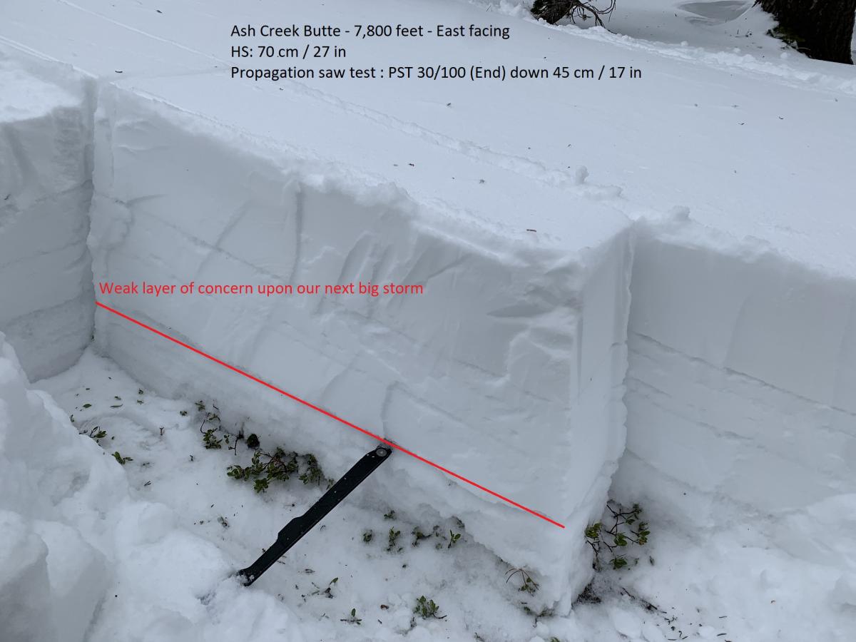
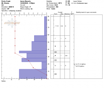
- Whumphing and unstable pit results have been observed/reported from a persistent weak layer that is still being found on cold, northerly facing areas west of I-5 in the Eddies and east of the mountain along the northeast crest. This layer has been difficult to find on the south side of Mount Shasta proper. Everyone should dig and monitor this layer while out on winter adventures. While not a concern now, a big dump could be enough weight to tip the scale. No slides have occurred on this layer. Below is a representative example of the layer of concern.

Weather and Current Conditions
Weather Summary
Yesterday afternoon marked the beginning of a long line of storms, a wave count of 5 around the globe, that will be marching our way over the next week. Each will have its own unique impact... most notably, snow!
Snow showers will diminish this morning. The wind has already kicked in and one should expect moderate, gusty northwesterlies today above treeline and other exposed terrain. Temperatures will float in the high twenties to low thirties. A few clouds will linger. I wouldn't be surprised to see a good bit of blue sky too. This short-lived break will end Friday evening as the next front moves on shore.
24 Hour Weather Station Data @ 4:00 AM
| Weather Station | Temp (°F) | Wind (mi/hr) | Snow (in) | Comments | ||||||||
|---|---|---|---|---|---|---|---|---|---|---|---|---|
| Cur | Min | Max | Avg | Avg | Max Gust | Dir | Depth | New | Water Equivalent | Settlement | ||
| Mt. Shasta City (3540 ft) | 30 | 29 | 42 | 32 | 2 | N | ||||||
| Sand Flat (6750 ft) | 27 | 0 | 32 | 24 | 0 | 0 | 0 | 0 | Depth sensor not working. | |||
| Ski Bowl (7600 ft) | 26 | 20 | 33 | 25.5 | 30.4 | 2.6 | 0.28 | 0 | ||||
| Gray Butte (8000 ft) | 20.5 | 19 | 29 | 22.5 | 14 | 55 | W | |||||
| Castle Lake (5870 ft) | 26 | 23 | 37.5 | 29 | 13.6 | 0.8 | 0 | |||||
| Mount Eddy (6509 ft) | 25.5 | 22 | 35 | 29 | 2 | 7 | SSE | 28.7 | 2.1 | 0 | ||
| Ash Creek Bowl (7250 ft) | 24 | 21 | 33 | 27 | 30.4 | 2.2 | 0 | |||||
| Ash Creek Ridge (7895 ft) | 21 | 18 | 30.5 | 23 | 10 | 47 | S |
Two Day Mountain Weather Forecast
Produced in partnership with the Medford NWS
| For 7000 ft to 9000 ft | |||
|---|---|---|---|
|
Thursday (4 a.m. to 10 p.m.) |
Thursday Night (10 p.m. to 4 a.m.) |
Friday (4 a.m. to 10 p.m.) |
|
| Weather | Slight chance of snow showers this morning, partly cloudy this afternoon. Snow level near 4,000 feet | Partly cloudy | Increasing clouds. Chance of snow in the evening. Snow level near 3,500 feet rising to 6,000 feet. |
| Temperature (°F) | 32 | 29 | 38 |
| Wind (mi/hr) | North 5-10 | Northeast 5-10 | South 5-10 |
| Precipitation SWE / Snowfall (in) | 0.00 / 0 | 0.00 / 0 | 0.15 / 0.25-0.50 |
| For 9000 ft to 11000 ft | |||
| Thursday | Thursday Night | Friday | |
| Weather | Slight chance of snow showers this morning, partly cloudy this afternoon. Windy. Wind chill near -13 | Partly cloudy, windy. | Partly cloudy. Snow likely after 4pm. Windy. Wind chill near -12 |
| Temperature (°F) | 22 | 19 | 26 |
| Wind (mi/hr) | Northwest 25-35 | Northwest 10-20 | Southwest 45-55 |
| Precipitation SWE / Snowfall (in) | 0.00 / 0 | 0.00 / 0 | 0.15 / 0.25-0.50 |
Season Precipitation for Mount Shasta City
| Period | Measured (in) | Normal (in) | Percent of Normal (%) |
|---|---|---|---|
| From Oct 1, 2025 (the wet season) | 3.58 | 14.96 | 24 |
| Month to Date (since Jun 1, 2026) | 1.88 | 7.60 | 25 |
| Year to Date (since Jan 1, 2026) | 16.49 | 42.96 | 38 |

