

You are here
Avalanche Forecast for 2021-01-01 05:45
- EXPIRED ON January 2, 2021 @ 5:45 amPublished on January 1, 2021 @ 5:45 am
- Issued by Nick Meyers - Shasta-Trinity National Forest
Bottom Line
The avalanche danger will remain low and normal caution is advised for the next 24 hours. Watch for small, isolated wind slabs in steep terrain. Anticipate changing conditions over the next several days as a series of storms impact the forecast area. Expect rising avalanche danger.
A thin snowpack is still presenting shallow buried objects. We are hoping this is no longer an issue after the weekend. Happy New Year lovely people.


Avalanche Problem 1: Normal Caution
-
Character ?

-
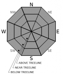
Aspect/Elevation ?
-
Likelihood ?CertainVery LikelyLikelyPossible
 Unlikely
Watch for isolated wind slabs in steep terrain with existing snow beneath. The majority of the avalanche terrain above treeline has been stripped of snow, leaving behind rocks, old icy snow surfaces and other sastrugi formations. The leeward SW/S/SE sides of moraines near treeline observed wind slabs 1 to 2 feet thick. It was difficult to cause failure on small, steep test slopes and in snow pits yesterday. Slabs are likely stubborn/unreactive to trigger today.
Forecast Discussion
- Join us for our second virtual Avalanche Awareness Presentation this Friday, January 1st at 7:00 p.m. With incoming snow expected after New Year's, this is a good time to refresh your knowledge and skills.
- Saturday, we will host Companion Rescue at Bunny Flat. Meet at 9 a.m. at The 5th Season or 9:15 at Bunny Flat trailhead. Bring your own equipment. We have some beacon demos available. Dress warm. The free, half-day class will take place near the parking lot.
Recent Observations
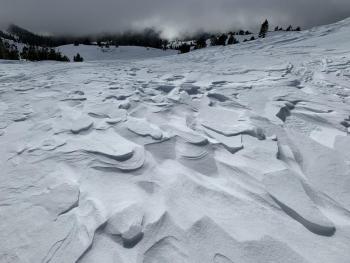
- A 36-hour W/NW wind event laid waste to the snowpack above treeline and blew most of the 2-3 inches of fresh snow away and scoured old snow surfaces. Spin drift could be seen reeling off the mountain to the southeast from Mt. Shasta City early in the morning. The freshly coated mountain was back to salt and pepper by 10 a.m. Winds had completely cease by noon, and it was nearly calm for the remainder of the day.
- Fresh, 1 - 2 foot thick wind slabs were observed on leeward SW/S/SE facing, low angle moraines. Slabs rest on old, crusty snow and were difficult to trigger. We had one early morning report of shooting cracks within new wind slabs off Green Butte Ridge, near treeline.
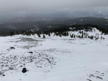
- Most major avalanche path starting zones on the mountain are devoid of snow.
- No avalanches have been observed or reported yet this season. We continue to monitor the persistent weak layer found in some of the more remote, cold, northerly facing locations of the forecast area.
- Snow surfaces are variable above treeline and better near and below in more protected areas and gullies.
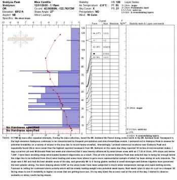
- See photos from yesterday's observation.

Weather and Current Conditions
Weather Summary
A line of storms will impact the area over the next week, ringing in the new year properly. One can expect the full gamut of winter weather: heavy rain, wind and mountain snowfall. All of it is welcome and beneficial given the ongoing drought conditions.
A front of moderate strength will enter the forecast area this afternoon bringing gusty winds and snowfall. It will be a slow start for the next couple of days in terms of heavy precipitation, but don't worry because it's coming. Today will observe increasing clouds and wind. Precipitation should begin late afternoon and will start the slow trickle of on again, off again snow showers into the weekend. Snow levels will reside mostly above 4,500 feet. Sunday through Tuesday looks like the real whopper with 2.5 inches of water in the forecast, which could mean several feet of snow in the mountains.
24 Hour Weather Station Data @ 4:00 AM
| Weather Station | Temp (°F) | Wind (mi/hr) | Snow (in) | Comments | ||||||||
|---|---|---|---|---|---|---|---|---|---|---|---|---|
| Cur | Min | Max | Avg | Avg | Max Gust | Dir | Depth | New | Water Equivalent | Settlement | ||
| Mt. Shasta City (3540 ft) | 30 | 26 | 44 | 31.5 | 1 | N | ||||||
| Sand Flat (6750 ft) | 25 | 0 | 33 | 22 | 0 | 0 | 0 | 0 | Depth sensor not working. | |||
| Ski Bowl (7600 ft) | 35.5 | 24 | 35.5 | 29.5 | 29.4 | 0 | 0 | 0.9 | ||||
| Gray Butte (8000 ft) | 34 | 21.5 | 34 | 27 | 3 | 43 | var | |||||
| Castle Lake (5870 ft) | 30.5 | 26 | 32 | 28.5 | 13 | 0 | 0.5 | |||||
| Mount Eddy (6509 ft) | 34 | 25 | 34 | 29 | 2 | 7 | SE | 27.3 | 0 | 1.3 | ||
| Ash Creek Bowl (7250 ft) | 31 | 23 | 31 | 25.5 | 30.2 | 0 | 0.4 | |||||
| Ash Creek Ridge (7895 ft) | 33 | 19 | 33 | 23.5 | 0 | 15 |
Two Day Mountain Weather Forecast
Produced in partnership with the Medford NWS
| For 7000 ft to 9000 ft | |||
|---|---|---|---|
|
Friday (4 a.m. to 10 p.m.) |
Friday Night (10 p.m. to 4 a.m.) |
Saturday (4 a.m. to 10 p.m.) |
|
| Weather | Partly to mostly cloudy, becoming windy. Snow after 4p.m. Snow level near 6,200 feet | Snow likely. Snow level near 4,200 feet | Cloudy, chance of snow in the morning, rain and snow likely in afternoon. Snow level near 4,500 feet. |
| Temperature (°F) | 38 | 25 | 27 |
| Wind (mi/hr) | Southeast 5-10 | South 10-15 | South 5-10 |
| Precipitation SWE / Snowfall (in) | 0.11 / 0-1 | 0.02 / 1-2 | 0.18 / 1-2 |
| For 9000 ft to 11000 ft | |||
| Friday | Friday Night | Saturday | |
| Weather | Increasing clouds, snow after 4 p.m. Windy | Snow before 10 p.m., then chance of snow after. Windy | Chance of snow before 10 a.m., then snow likely after 4 p.m. Windy. |
| Temperature (°F) | 29 | 15 | 24 |
| Wind (mi/hr) | West 20-25 | Southwest 35-45 | West 25-35 |
| Precipitation SWE / Snowfall (in) | 0.11 / 0-1 | 0.02 / 1-3 | 0.18 / 1-2 |
Season Precipitation for Mount Shasta City
| Period | Measured (in) | Normal (in) | Percent of Normal (%) |
|---|---|---|---|
| From Oct 1, 2025 (the wet season) | 3.58 | 15.21 | 24 |
| Month to Date (since Jun 1, 2026) | 1.88 | 7.85 | 24 |
| Year to Date (since Jan 1, 2026) | 16.49 | 43.21 | 38 |

