

You are here
Avalanche Forecast for 2021-01-02 05:59
- EXPIRED ON January 3, 2021 @ 5:59 amPublished on January 2, 2021 @ 5:59 am
- Issued by Nick Meyers - Shasta-Trinity National Forest
Bottom Line
The avalanche danger is LOW. After 4 p.m., the onset of new snow and west/southwest wind will bring wind slabs into the chat. Anticipate changing conditions and new wind slab formation near and above treeline. The Mt. Shasta area will see a gradual crescendo in wind, rain and snow over the weekend and into next week.


Avalanche Problem 1: Wind Slab
-
Character ?

-
Aspect/Elevation ?
-
Likelihood ?CertainVery LikelyLikelyPossible
 Unlikely
 -
Size ?HistoricVery LargeLargeSmall

For shredders today, the size, distribution and sensitivity of wind slabs will be small, isolated and unlikely to trigger. But, it's time to start thinking about new wind slabs in the backcountry. The Shasta snow machine and west/northwest wind will start to get warmed up today. Minimal snow accumulation is expected during daylight hours. Tonight, snow and wind will begin to work together to form new wind slabs on the right half of the compass (N-NE-E-SE-S) near and above treeline. If you are traveling in avalanche terrain and suddenly come across smooth, rounded wind pillow(s)...this is your clue that you might be tromping out onto a fresh wind slab. Always pay attention to wind blowing snow while in the backcountry...it is one of the 5 red flags of avalanche danger.
Forecast Discussion
- A winter storm watch has been issued by the NWS late Sunday night through late Monday night above 5,000 feet.
- Today we will host Companion Rescue at Bunny Flat. Meet at 9 a.m. at The 5th Season or 9:15 at Bunny Flat trailhead. Bring your own equipment. We have some beacon demos available. Dress warm. The free, half-day class will take place near the parking lot.
- Bunny Flat has been busy. Please park responsibly. All truck and trailer/sled decks with snowmobiles should park downhill, below the restroom facilities. Keep the sled access ramp clear. Thank you!
- The Sand Flat winter trails are in good shape. Pilgrim Creek snowmobile park is open. The snowpack at the park is thin.
- Castle Lake has a barely usable snowpack with only 12 inches on the ground.
- The Eddy Mountains have 25-30 inches of snow and better coverage.
Recent Observations
- Last night from 1800 to 2000 hours, about an inch of new snow fell (0.1" snow/water equivalent - SWE)
- Yesterday was a gray and warm day. Temperatures topped out at 41 degrees F at 1000 hours. Winds were calm up until 1100 hours. Moderate westerly winds kicked in and continue this morning.
- The snowpack turned into a hot mess yesterday, which means crusty today. Ski skins were glopping, trees have shed all their snow and loose, roller balls were observed on below treeline, south facing slopes.
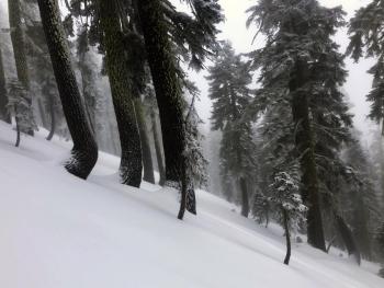
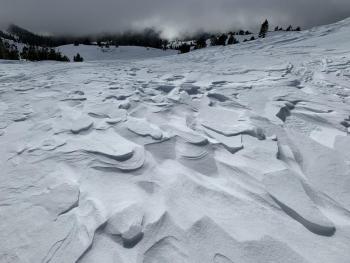
- Above treeline, our recent W/NW wind event did a number to the snowpack, leaving behind scabby wind slabs, icy crusts, packed powder and other gnarly sastrugi formations. Moments of ski brilliance can be found in select areas, primarily near/below treeline, protected, shaded gullies. Overall, the warm temps killed that smooth sliding feeling.
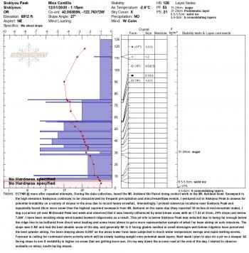
- The majority of the snowpack is set up well for additional snow load. We continue to poke around and monitor the persistent weak layer that's been observed on cold, northerly facing aspects around the fringe of the forecast area. Recent signs of instability have been few and concern is low at this time.
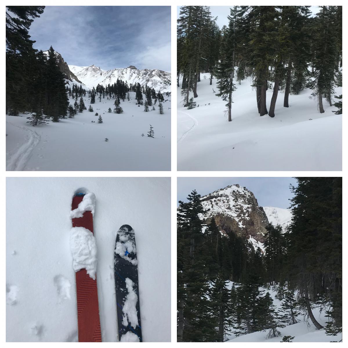
Several pictures from a below and near treeline tour on the south side of Mt. Shasta - 1.1.21 - [Photos: H Meyers]

Weather and Current Conditions
Weather Summary
Northern California is locked into a progressive weather pattern that will remain in place through the coming week with fresh systems moving onshore every couple of days. A winter storm watch is in effect from late Sunday night through late Monday night above 5,000 feet. For the daylight hours today, Mother Nature will begin to rev her engine and warm up the storm train. Very little precipitation is expected but should pick up later tonight. By tomorrow, we should have 3 - 6 inches of new snow above 5,500 feet. Strong west/southwest winds above treeline are also expected tonight into Monday. A slow start to the action, but by the end of next week, several feet of new snow is likely in the mountains.
24 Hour Weather Station Data @ 4:00 AM
| Weather Station | Temp (°F) | Wind (mi/hr) | Snow (in) | Comments | ||||||||
|---|---|---|---|---|---|---|---|---|---|---|---|---|
| Cur | Min | Max | Avg | Avg | Max Gust | Dir | Depth | New | Water Equivalent | Settlement | ||
| Mt. Shasta City (3540 ft) | 37 | 29 | 48 | 37.5 | 2 | N | ||||||
| Sand Flat (6750 ft) | 27 | 0 | 37 | 25 | 0 | 0 | 0 | 0 | Depth sensor not working. | |||
| Ski Bowl (7600 ft) | 23 | 22.5 | 41 | 30 | 30 | 0.5 | 0.1 | 0 | ||||
| Gray Butte (8000 ft) | 22 | 21.5 | 37.5 | 28.5 | 8 | 43 | W | |||||
| Castle Lake (5870 ft) | 28 | 27 | 42 | 32 | 13.8 | 1 | 0 | |||||
| Mount Eddy (6509 ft) | 26 | 25 | 43.5 | 31.5 | 1 | 4 | WSW | 27.8 | 0.3 | 0 | ||
| Ash Creek Bowl (7250 ft) | 24.5 | 23.5 | 40 | 29.5 | 29.7 | 0 | 0.2 | |||||
| Ash Creek Ridge (7895 ft) | 21 | 20.5 | 36 | 27.5 | 9 | 50 | S |
Two Day Mountain Weather Forecast
Produced in partnership with the Medford NWS
| For 7000 ft to 9000 ft | |||
|---|---|---|---|
|
Saturday (4 a.m. to 10 p.m.) |
Saturday Night (10 p.m. to 4 a.m.) |
Sunday (4 a.m. to 10 p.m.) |
|
| Weather | Mostly cloudy, a 30% chance of snow after 10 a.m. Total daytime accumulation less than 1 inch. Snow level near 4,600 feet. | Cloudy, rain and snow likely. Snow accumulation 2-4 inches. Snow level near 4,900 feet. | Snow likely, cloudy, breezy. Snow accumulation 2-3 inches. Snow level near 5,200 feet. |
| Temperature (°F) | 30 | 27 | 33 |
| Wind (mi/hr) | South 10-15 | South 10-15 | South 10-15 |
| Precipitation SWE / Snowfall (in) | 0.05 / 0-1 | 0.07 / 2-4 | 0.30 / 2-4 |
| For 9000 ft to 11000 ft | |||
| Saturday | Saturday Night | Sunday | |
| Weather | Mostly cloudy, 30% chance of snow after 10 a.m. Windy. Wind chill near -10 | Snow likely, mainly after 10 p.m. Cloudy. Windy. Areas of blowing snow. | Snow likely, mainly before 4 p.m. Cloudy. Windy. |
| Temperature (°F) | 22 | 17 | 20 |
| Wind (mi/hr) | West/Southwest 30-40 | West/Southwest 40-50 | West/Southwest 30-40 |
| Precipitation SWE / Snowfall (in) | 0.05 / 0-1 | 0.07 / 3-5 | 0.30 / 3-7 |
Season Precipitation for Mount Shasta City
| Period | Measured (in) | Normal (in) | Percent of Normal (%) |
|---|---|---|---|
| From Oct 1, 2025 (the wet season) | 3.66 | 15.45 | 24 |
| Month to Date (since Jun 1, 2026) | 0.08 | 0.24 | 33 |
| Year to Date (since Jan 1, 2026) | 0.08 | 0.24 | 33 |

