

You are here
Avalanche Forecast for 2021-01-03 06:55
- EXPIRED ON January 4, 2021 @ 6:55 amPublished on January 3, 2021 @ 6:55 am
- Issued by Ryan Sorenson - Mount Shasta Avalanche Center
Bottom Line
The avalanche danger will increase to MODERATE near and above treeline today as fresh snow combines with west/southwest wind. Human triggered wind slab avalanches are possible on steep leeward slopes. Anticipate changing conditions. Heavy snowfall is expected after 4 a.m. tomorrow.


Avalanche Problem 1: Wind Slab
-
Character ?

-
Aspect/Elevation ?
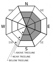
-
Likelihood ?CertainVery LikelyLikelyPossible
 Unlikely
 -
Size ?HistoricVery LargeLargeSmall

Increasing snowfall will mix with productive west/southwest winds today. Models predict 3 to 5 inches of snow accumulation above 5,300 feet. Watch for fresh wind slab development on N-NE-E-SE-S aspects. Wind slabs are expected to be small to medium-sized and potentially reactive to human triggering. Small wind slabs were stubborn to unreactive on test slopes yesterday.
Continue to stay in the avalanche mindset and pay attention to the wind blowing snow as you travel in the backcountry. Ask yourself where wind slabs might be forming. Use small test slopes out of avalanche terrain to stomp around on and look for cracking and blocking within the snowpack. Pay attention to areas that you find smooth, rounded, hollow-sounding pillows of snow. Adjust travel plans to minimize exposure to wind slabs on steep slopes. Anticipate wind slabs to grow larger as we receive more snow and wind over the next few days.
Forecast Discussion
- The NWS issued a winter storm warning from 4 a.m. Monday to 4 a.m. Tuesday above 5,000 feet.
- Bunny Flat has been busy. Please park responsibly. All truck and trailer/sled decks with snowmobiles should park downhill, below the restroom facilities. Keep the sled access ramp clear.
- Thanks to everyone that joined us at our virtual Know Before You Go avalanche awareness presentation and the companion rescue clinic this weekend. We had a good showing, and we are excited to share the stoke!
Below is a satellite image that shows a very impressive plume of moisture headed our way.

Recent Observations
- Over the last 48 hours, Mount Shasta has received 1-2 inches of new snow (0.17" snow/water equivalent - SWE)
- Yesterday was overcast, foggy, and misty. Periods of very light snowfall above 6,000 feet continued throughout the day.
- Temperatures maxed out at 26 °F at noon and averaged 25 °F over the past 24 hours at 7,600 feet on Mount Shasta.
- Westerly winds have continued to be moderate on Grey Butte. Observations reported calm to light winds below and near treeline.
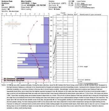
- The new snow sits over a thin zipper crust formed during the warm period on New Years Day. Below that, up to a foot of fist to four-finger hard snow rests on several old crusts to the ground.
- The total snow height is 31.4 inches at our Old Ski Bowl weather station on Mount Shasta.
- Small wind slabs up to a foot deep have been observed on ridgelines. These were stubborn to unreactive during compression tests and on small test slopes.
- The Sand Flat winter trails are in good shape.
- Pilgrim Creek snowmobile park is open. The snowpack at the park is thin.
- Castle Lake has a barely usable snowpack with only 14 inches on the ground.
- The Eddy Mountains have 25-30 inches of snow and better coverage.

Weather and Current Conditions
Weather Summary
A significant storm front is barreling down on Northern California. Expect a gradual increase in snowfall today, followed by an onslaught of heavy snowfall early tomorrow morning. Strong west/southwest winds will accompany the new snow over the next 48 hours. Cloudy skies, breezy conditions, and blowing snow are likely. There is a winter storm warning in effect from 4 a.m. Monday to 4 a.m. Tuesday above 5,000 feet.
We will pick up 3 to 5 inches of snow accumulation above 5,300 feet today. Another 1 to 3 inches is expected above 5,700 this evening. Heavy snowfall is scheduled to begin around 4 am tomorrow. Expect 12 to 17 inches of snow accumulation above 5,100 feet by tomorrow night.
24 Hour Weather Station Data @ 6:00 AM
| Weather Station | Temp (°F) | Wind (mi/hr) | Snow (in) | Comments | ||||||||
|---|---|---|---|---|---|---|---|---|---|---|---|---|
| Cur | Min | Max | Avg | Avg | Max Gust | Dir | Depth | New | Water Equivalent | Settlement | ||
| Mt. Shasta City (3540 ft) | 38 | 36 | 38 | 37.5 | 3 | ESE | ||||||
| Sand Flat (6750 ft) | 29 | 0 | 29 | 26 | Depth sensor not working. | |||||||
| Ski Bowl (7600 ft) | 25 | 22.5 | 26 | 24.5 | 31.1 | 1.1 | 0.06 | 0 | ||||
| Gray Butte (8000 ft) | 24 | 22 | 25 | 23.5 | 15 | 37 | W | |||||
| Castle Lake (5870 ft) | 29.5 | 28 | 31.5 | 29.5 | 14.9 | 1.1 | 0 | |||||
| Mount Eddy (6509 ft) | 27.5 | 26 | 35.5 | 29 | 2 | 6 | SE | 27.9 | 0 | 0 | ||
| Ash Creek Bowl (7250 ft) | 26.5 | 24 | 27 | 26 | 29.6 | 0 | 0 | |||||
| Ash Creek Ridge (7895 ft) | 21 | 20.5 | 36 | 27.5 | 9 | 50 | S |
Two Day Mountain Weather Forecast
Produced in partnership with the Medford NWS
| For 7000 ft to 9000 ft | |||
|---|---|---|---|
|
Sunday (4 a.m. to 10 p.m.) |
Sunday Night (10 p.m. to 4 a.m.) |
Monday (4 a.m. to 10 p.m.) |
|
| Weather | Snow likely. Patchy blowing snow this morning then blowing snow this afternoon. Snow level near 5,300 feet. | Cloudy, rain and snow likely. Chance of snow 30 percent. Snow level near 5,700 feet. | Snow likely, cloudy, breezy. Snow level near 5,100 feet. |
| Temperature (°F) | 35 | 32 | 35 |
| Wind (mi/hr) | South 10-15 | South 15-20 | South 20-25 |
| Precipitation SWE / Snowfall (in) | 0.25 / 3-5 | 0.13 / 1-3 | 1.43 / 12-17 |
| For 9000 ft to 11000 ft | |||
| Sunday | Sunday Night | Monday | |
| Weather | Snow likely. Patchy blowing snow this morning then blowing snow this afternoon. Windy. Wind chill values as low as -7. | Cloudy, snow likely. Chance of snow 30 percent. Cloudy. Windy. Areas of blowing snow. | Snow, mainly before 4 pm. Heavy snowfall. Widespread blowing snow. Wind chill values as low as -16. |
| Temperature (°F) | 23 | 21 | 24 |
| Wind (mi/hr) | West/Southwest 30-40 | West/Southwest 45-55 | West/Southwest 50-60 |
| Precipitation SWE / Snowfall (in) | 0.25 / 3-6 | 0.13 / 1-3 | 1.43 / 14-18 |
Season Precipitation for Mount Shasta City
| Period | Measured (in) | Normal (in) | Percent of Normal (%) |
|---|---|---|---|
| From Oct 1, 2025 (the wet season) | 3.68 | 15.69 | 23 |
| Month to Date (since Jun 1, 2026) | 0.10 | 0.48 | 21 |
| Year to Date (since Jan 1, 2026) | 0.10 | 0.48 | 21 |

