

You are here
Avalanche Forecast for 2021-01-05 06:00
- EXPIRED ON January 6, 2021 @ 6:00 amPublished on January 5, 2021 @ 6:00 am
- Issued by Aaron Beverly - Mount Shasta Avalanche Center
Bottom Line
Avalanche danger is moderate. Evaluate steep leeward terrain carefully. Wind slabs may have formed in these areas and may continue to build. Be wary of rock hazards above treeline. A bit more snow is scheduled to fall tomorrow above 4,100 ft.


Avalanche Problem 1: Wind Slab
-
Character ?

-
Aspect/Elevation ?
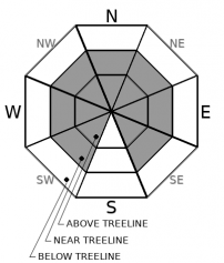
-
Likelihood ?CertainVery LikelyLikelyPossible
 Unlikely
 -
Size ?HistoricVery LargeLargeSmall

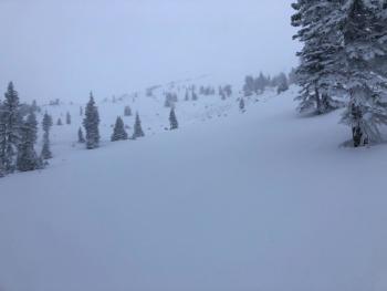
Productive northwest winds blew all day yesterday. Moderate to strong westerly winds will continue today and tomorrow. There is 8-10 inches of light snow available to move around. Wind slabs may be out there and may continue to build.
As you travel in low angle terrain, stomp around in wind loaded areas of no consequence. Do you see blocking? Shooting cracks? Can you get slabs to move on steep rollovers? These are signs that wind slabs are forming. Approach steep leeward slopes with caution.
Forecast Discussion
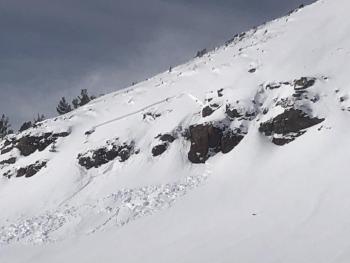
If you are venturing above treeline, you should continue to evaluate rock hazards. The wind blew much of our new snow away. Deep carves may still lead to core shots and broken a-arms.
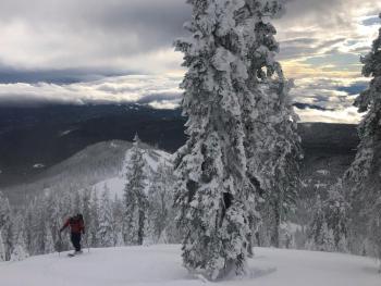
Below treeline, things have filled in more, but expect some tricky manzaneering if you get too low. Gray Butte travelers attempting to traverse back to the ski park will encounter mounds of chaparral.
Recent Observations
Yesterday's storm was a bit underwhelming. Yes, we got about 5-10 inches out of it, but that wasn't the 15 inches expected. But beggars can't be choosers. We'll take it.
Winds were light below treeline, but picked up into the moderate to strong range near and above treeline. Northwest winds were productive in transporting snow, though by 2:30 p.m. no notable wind slabs or cornices were seen in leeward areas. The small ones encountered were mostly stubborn to trigger. A bit of blocking was observed, but no shooting cracks. Ridges and moraines on the upper mountain were already becoming scoured and windward slopes were developing sustrugis.
Aside from productive winds transporting snow, no obvious signs of avalanche danger were encountered. Moderate northwest winds blew continuously until 10 p.m.
Weather and Current Conditions
Weather Summary
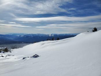
It should be a beautiful, sunny day for skiing the new pow near and below treeline. Above treeline, west/southwest winds will be strong. Expect wind-affected snow and scoured moraines and ridges at higher elevations.
A front begins moving in tonight which will set us up for another dousing of snow (2-5 inches) tomorrow above 4,100 ft. This will be accompanied by increasing, strong southwest winds.
24 Hour Weather Station Data @ 5:00 AM
| Weather Station | Temp (°F) | Wind (mi/hr) | Snow (in) | Comments | ||||||||
|---|---|---|---|---|---|---|---|---|---|---|---|---|
| Cur | Min | Max | Avg | Avg | Max Gust | Dir | Depth | New | Water Equivalent | Settlement | ||
| Mt. Shasta City (3540 ft) | 32 | 29 | 42 | 35 | 1 | N | ||||||
| Sand Flat (6750 ft) | 20 | 0 | 32 | 24 | Depth sensor not working. | |||||||
| Ski Bowl (7600 ft) | 17.5 | 15 | 28 | 22 | 44.9 | 10.4 | 0.81 | 0 | ||||
| Gray Butte (8000 ft) | 15 | 15 | 27 | 21 | 17 | 55 | NW | |||||
| Castle Lake (5870 ft) | 25 | 22 | 31.5 | 27.5 | 19.6 | 5.8 | 0 | |||||
| Mount Eddy (6509 ft) | 20.5 | 16.5 | 31 | 24.5 | 1 | 7 | 35.4 | 5.1 | 0 | |||
| Ash Creek Bowl (7250 ft) | 18.5 | 17 | 28.5 | 23.5 | 35.6 | 5.8 | 0 | |||||
| Ash Creek Ridge (7895 ft) | 24.5 | 24 | 27.5 | 26 | wind sensor rimed |
Two Day Mountain Weather Forecast
Produced in partnership with the Medford NWS
| For 7000 ft to 9000 ft | |||
|---|---|---|---|
|
Tuesday (4 a.m. to 10 p.m.) |
Tuesday Night (10 p.m. to 4 a.m.) |
Wednesday (4 a.m. to 10 p.m.) |
|
| Weather | Mostly sunny. | Snow likely after 4 a.m. Mostly cloudy. Chance of precipitation is 60%. | Snow, mainly before 4 p.m. Chance of precipitation is 80%. |
| Temperature (°F) | 33 | 31 | 27 |
| Wind (mi/hr) | South 5-10 | South 5-10 | South 10-15 |
| Precipitation SWE / Snowfall (in) | 0.00 / 0 | 0.00 / 0 | 0.44 / 2-5 |
| For 9000 ft to 11000 ft | |||
| Tuesday | Tuesday Night | Wednesday | |
| Weather | Mostly sunny. Breezy. | Snow likely after 4 a.m. Mostly cloudy. Windy, Chance of precipitation is 60%. | Snow, mainly before 4 p.m. Windy. Low wind chills. Chance of precipitation is 80%. |
| Temperature (°F) | 27 | 25 | 26 |
| Wind (mi/hr) | West 25-30 | Southwest 35-40 | Southwest 40-50 |
| Precipitation SWE / Snowfall (in) | 0.00 / 0 | 0.00 / 0 | 0.44 / 2-5 |
Season Precipitation for Mount Shasta City
| Period | Measured (in) | Normal (in) | Percent of Normal (%) |
|---|---|---|---|
| From Oct 1, 2025 (the wet season) | 5.03 | 16.15 | 31 |
| Month to Date (since Jun 1, 2026) | 1.45 | 0.94 | 154 |
| Year to Date (since Jan 1, 2026) | 1.45 | 0.94 | 154 |

