

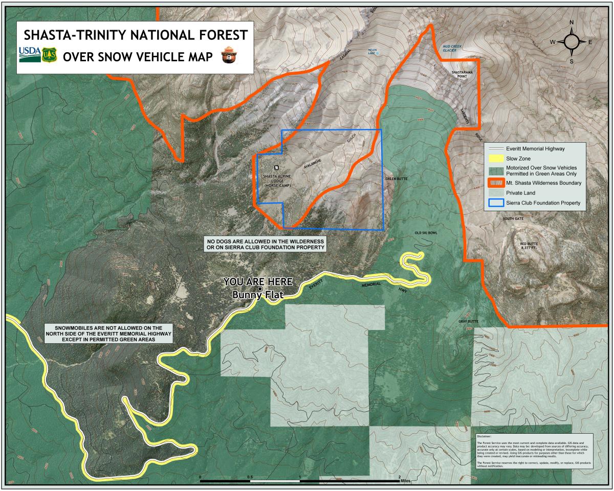
You are here
Avalanche Forecast for 2021-01-06 06:30
- EXPIRED ON January 7, 2021 @ 6:30 amPublished on January 6, 2021 @ 6:30 am
- Issued by Aaron Beverly - Mount Shasta Avalanche Center
Bottom Line
Overall avalanche danger is low. Isolated wind slabs may still be found on steep leeward slopes. Low lying areas above treeline have been filled in with new snow, but hidden obstacles still exist. Expect 1-3 inches of new snow today above 4,300 ft.


Avalanche Problem 1: Wind Slab
-
Character ?

-
Aspect/Elevation ?
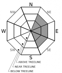
-
Likelihood ?CertainVery LikelyLikelyPossible
 Unlikely
 -
Size ?HistoricVery LargeLargeSmall

Overall avalanche danger is low. This is not an excuse for complacency. Small wind slabs may still linger in isolated areas. Blowing snow may still form new ones. Pay attention on steep leeward slopes.
Forecast Discussion
If you have a dog, there are a plethora of places you can go around Bunny Flat. But some areas are off limits. Please respect the boundaries. Thank you!
We'll be hosting a snowmobile-centric avalanche awareness and companion rescue clinic this weekend:
- Avalanche Awareness: January 8th @ 7 p.m. via Zoom. Stay tuned for details and links.
- Companion Rescue: January 9th @ 9 a.m. Bunny Flat. Bring masks and park below the bathrooms.
Recent Observations
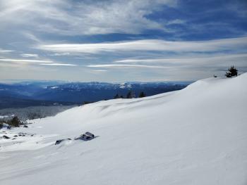
The Old Ski Bowl holds about 10-12 inches of new snow and over 40 inches total. As of 2 p.m. yesterday, above treeline snow surfaces were becoming slightly affected by moderate westerly winds, though weather stations show winds tapering off soon after. Ridges were more scoured.
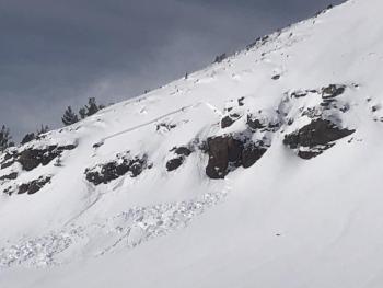
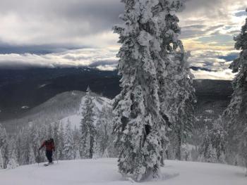
A small, D1 wind-slab avalanche was triggered by a snowboarder in the Powder Bowl area. Aside from this, there were no concerning signs of wind slab formation in the Mount Shasta area. Those exploring some of the more remote regions around Mount Eddy saw wind transported snow, cracking, and some small, fresh wind slabs.
Monday's storm filled in lower lying areas above treeline and it is very tempting to open up those throttles and dig in deep. The snowpack is still fairly shallow, so I'd continue to be cautious of lurking rocks. Snowmobilers in the Eddies were still hitting objects below the snow surface.
Weather and Current Conditions
Weather Summary
Today, expect 1-3 inches of snow above 4,300 ft. Westerly winds will be strong and gusty above treeline.
Tomorrow night we could get up to 6 inches. After that, high pressure will shut off the faucet for a while.
24 Hour Weather Station Data @ 5:00 AM
| Weather Station | Temp (°F) | Wind (mi/hr) | Snow (in) | Comments | ||||||||
|---|---|---|---|---|---|---|---|---|---|---|---|---|
| Cur | Min | Max | Avg | Avg | Max Gust | Dir | Depth | New | Water Equivalent | Settlement | ||
| Mt. Shasta City (3540 ft) | 31 | 29 | 46 | 35 | 0 | N | ||||||
| Sand Flat (6750 ft) | 25 | 15 | 32 | 25 | 0 | 0 | Depth sensor not working. | |||||
| Ski Bowl (7600 ft) | 29.5 | 15 | 32 | 26 | 42.8 | 0 | 0 | 2.3 | ||||
| Gray Butte (8000 ft) | 29 | 15 | 31 | 24.5 | 15 | 37 | W | |||||
| Castle Lake (5870 ft) | 30 | 21.5 | 36.5 | 29.5 | 21.1 | 1.6 | 0 | |||||
| Mount Eddy (6509 ft) | 32.5 | 19.5 | 34.5 | 29.5 | 1 | 4 | 34.7 | 0 | 0.7 | |||
| Ash Creek Bowl (7250 ft) | 18.5 | 17 | 28.5 | 23.5 | 35.6 | 5.8 | 0 | |||||
| Ash Creek Ridge (7895 ft) | 23.5 | 15.5 | 27 | 22.5 | 40 | wind sensor rimed |
Two Day Mountain Weather Forecast
Produced in partnership with the Medford NWS
| For 7000 ft to 9000 ft | |||
|---|---|---|---|
|
Wednesday (4 a.m. to 10 p.m.) |
Wednesday Night (10 p.m. to 4 a.m.) |
Thursday (4 a.m. to 10 p.m.) |
|
| Weather | Snow before 1 p.m., then snow showers, mainly between 1 p.m. and 4 p.m. Breezy. Chance of precipitation is 100%. | A 30 percent chance of snow showers before 10 p.m. Partly cloudy. | A 30 percent chance of snow after 4 p.m. Partly sunny. |
| Temperature (°F) | 27 | 27 | 35 |
| Wind (mi/hr) | South 15-20 | Southwest 5-10 | Southeast 5-10 |
| Precipitation SWE / Snowfall (in) | 0.23 / 1-3 | 0.00 / 0 | 0.10 / 0-0.50 |
| For 9000 ft to 11000 ft | |||
| Wednesday | Wednesday Night | Thursday | |
| Weather | Snow before 1 p.m., then snow showers, mainly between 1 p.m. and 4 p.m. Windy. Low wind chills. Chance of precipitation is 90%. | A 40 percent chance of snow showers before 10 p.m. Mostly cloudy, then gradually becoming mostly clear. Windy. Low wind chills. | A 30 percent chance of snow after 4 p.m. Partly sunny. |
| Temperature (°F) | 26 | 17 | 27 |
| Wind (mi/hr) | Southwest 45-55 | Northwest 35-40 | South 15-20 |
| Precipitation SWE / Snowfall (in) | 0.23 / 1-3 | 0.00 / 0 | 0.10 / 0.50-1 |
Season Precipitation for Mount Shasta City
| Period | Measured (in) | Normal (in) | Percent of Normal (%) |
|---|---|---|---|
| From Oct 1, 2025 (the wet season) | 5.03 | 16.38 | 31 |
| Month to Date (since Jun 1, 2026) | 1.45 | 1.17 | 124 |
| Year to Date (since Jan 1, 2026) | 1.45 | 1.17 | 124 |

