

You are here
Avalanche Forecast for 2021-01-13 06:30
- EXPIRED ON January 14, 2021 @ 6:30 amPublished on January 13, 2021 @ 6:30 am
- Issued by Aaron Beverly - Mount Shasta Avalanche Center
Bottom Line
Avalanche danger is low. Yesterday's storm is breaking and is leaving us with mostly rain and wet snow. And not much of it. You might find an isolated wind slab up high, but overall, normal caution is advised. A period of mostly clear skies and melt-freeze cycles lie ahead.


Avalanche Problem 1: Normal Caution
-
Character ?

-
Aspect/Elevation ?
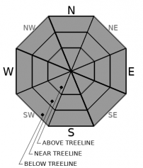
-
Likelihood ?CertainVery LikelyLikelyPossible
 Unlikely
 -
Size ?HistoricVery LargeLargeSmall

Overall avalanche danger is low. Yesterday's storm was warm and wet and sent meager amounts of snow. There may be isolated wind slabs out there at high elevations, but they'll be small and hard to find. However, low avalanche danger should not give you license to turn off your head. Stay in the game. Pay attention as you ascend. Wind drifts, cracking, and blocking are signs that a wind slab may lurk nearby on a steep, leeward slope. Continue to bring your beacon, shovel, and probe. Practice safe travel techniques.
Forecast Discussion
This year's annual super-spreader event, The Snowball, will be held online thanks to COVID-19. You'll have to party hardy at home, but while you do so, bid for cool items and win sick prizes virtually. It'll be hard not seeing y'all in person, but let's make the best of it. Register to participate by clicking below. Thank you for supporting us!

Recent Observations
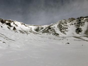
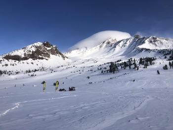
Yesterday, by 1:00 p.m., there was about an inch of moist snow on top of a soft, melt-freeze crust near and above treeline. Snow levels started at around 6,200 ft and were rising. Whiteout conditions made for wonky traveling above treeline, though some enthusiastic folks were making a go of it. Even the most experienced were tipping over hilariously. We could get no eyes on the upper mountain.
All of our weather stations have been buried in the clouds and are reporting negligible snow accumulation. This means most precipitation in the last 24 hours was in the form of rain or wet snow. The Old Ski Bowl has received 0.25 inches of water, far less than the 1 inch forecasted. Temperatures were steady, averaging 31 ºF. Moderate westerly winds blew all afternoon and night.
Weather and Current Conditions
Weather Summary
A rainy 24 hours with soul crushing snow levels have officially ushered in Juneuary. A period of mostly sunny weather is ahead accompanied by above freezing temperatures during the day and near freezing temperatures at night. You may be skiing corn by early next week.
A bit more rain (0.11 in) is expected this morning below 8,000 ft. No notable snow accumulation is expected. Westerly winds will be moderate to strong.
24 Hour Weather Station Data @ 5:00 AM
| Weather Station | Temp (°F) | Wind (mi/hr) | Snow (in) | Comments | ||||||||
|---|---|---|---|---|---|---|---|---|---|---|---|---|
| Cur | Min | Max | Avg | Avg | Max Gust | Dir | Depth | New | Water Equivalent | Settlement | ||
| Mt. Shasta City (3540 ft) | 43 | 40 | 43 | |||||||||
| Sand Flat (6750 ft) | 33 | 31 | 33 | 33 | Snow depth not working | |||||||
| Ski Bowl (7600 ft) | 31 | 28 | 31.5 | 30.5 | 43.9 | 0.3 | 0.24 | 0 | ||||
| Gray Butte (8000 ft) | 29.5 | 26 | 30.5 | 29 | 16 | 49 | W | |||||
| Castle Lake (5870 ft) | 35.5 | 31 | 35.5 | 32.5 | 23.2 | 0 | 0.1 | |||||
| Mount Eddy (6509 ft) | 35 | 29 | 39 | 31.5 | 2 | 5 | SW | 34.8 | 0 | 2 | ||
| Ash Creek Bowl (7250 ft) | 34.5 | 28.5 | 34.5 | 31 | 35 | 0.5 | 0 | |||||
| Ash Creek Ridge (7895 ft) | 32.5 | 25.5 | 32.5 | 28.5 | Wind sensor rimed |
Two Day Mountain Weather Forecast
Produced in partnership with the Medford NWS
| For 7000 ft to 9000 ft | |||
|---|---|---|---|
|
Wednesday (4 a.m. to 10 p.m.) |
Wednesday Night (10 p.m. to 4 a.m.) |
Thursday (4 a.m. to 10 p.m.) |
|
| Weather | Rain showers before 10 a.m., then a slight chance of rain and snow showers after 1 p.m. Snow level 7,800 ft. High near 40. Breezy. Chance of precipitation is 80%. | Mostly clear. | Sunny. |
| Temperature (°F) | 40 | 38 | 48 |
| Wind (mi/hr) | Southwest 15-20 | Northeast 0-5 | East 0-5 |
| Precipitation SWE / Snowfall (in) | 0.11 / 0-0.50 | 0.00 / 0 | 0.00 / 0 |
| For 9000 ft to 11000 ft | |||
| Wednesday | Wednesday Night | Thursday | |
| Weather | Snow before 10 a.m., then a slight chance of snow showers after 1 p.m. Windy. Chance of precipitation is 80%. | Mostly clear. Breezy. | Sunny. |
| Temperature (°F) | 33 | 33 | 42 |
| Wind (mi/hr) | West 45-55 | Northwest 20-25 | West 15-20 |
| Precipitation SWE / Snowfall (in) | 0.11 / 0-1 | 0.00 / 0 | 0.00 / 0 |
Season Precipitation for Mount Shasta City
| Period | Measured (in) | Normal (in) | Percent of Normal (%) |
|---|---|---|---|
| From Oct 1, 2025 (the wet season) | 5.65 | 18.10 | 31 |
| Month to Date (since Jun 1, 2026) | 2.07 | 2.89 | 72 |
| Year to Date (since Jan 1, 2026) | 2.07 | 2.89 | 72 |

