

You are here
Avalanche Forecast for 2021-01-30 06:30
- EXPIRED ON January 31, 2021 @ 6:30 amPublished on January 30, 2021 @ 6:30 am
- Issued by Nick Meyers - Shasta-Trinity National Forest
Bottom Line
The state of the snowpack is a little more complicated than usual around here. We've got several feet of existing storm snow, areas of newly formed surface hoar and another robust winter storm that will impact the area today through Monday. This will create tricky avalanche conditions. The danger will rise to CONSIDERABLE, requiring careful snowpack evaluation, cautious route finding and conservative decision-making. High danger is possible tomorrow.


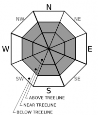
Avalanche Problem 1: Wind Slab
-
Character ?

-
Aspect/Elevation ?
-
Likelihood ?CertainVery LikelyLikelyPossible
 Unlikely
 -
Size ?HistoricVery LargeLargeSmall

Surface hoar has formed on some northerly aspects, all the way up to ridge lines...ideal locations for wind slabs to form. With a storm on the way today, buried surface hoar is a classic weak layer and recipe for an avalanche. There is and will continue to be PLENTY of soft snow available for wind transport. Expect new and old wind slabs on leeward, northerly aspects. Shifting winds may form wind slabs in unusual places. While winds were generally light yesterday, south wind will blow today. The best window for natural wind slabs is during or just after a storm. Large, fragile cornices exist out there too.
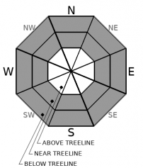
Avalanche Problem 2: Storm Slab
-
Character ?

-
Aspect/Elevation ?
-
Likelihood ?CertainVery LikelyLikelyPossible
Unlikely
-
Size ?HistoricVery LargeLargeSmall
With another round of snow on the way, storm slabs are back on the problem list. Variables such as temperature changes, fluctuating snowfall rate, type of snow crystals and shifty wind creates weaknesses within the storm snow. Expect storm slab avalanches as new snow builds later today and tonight. Areas with buried surface hoar could be sensitve to trigger. Storm slabs can involve part or all of the storm snow and can gouge down into existing, soft layers. Any steep slope and any aspect below and near treeline may be suspect as feet of new snow build up. In areas where the storm snow lacks cohesion, loose dry sluffs are possible.
Forecast Discussion
- The Everitt Memorial Highway and Castle Lake road remain closed.
- Snowmobiles have been launching from McBride Springs and riding up on the mountain in many areas that are prohibited for motorized equipment. This behavior is not tolerated. Know your boundaries. Just because the gate is closed does not make it a free for all. There is a map at Bunny Flat of legal riding areas. Violators will be cited.
Recent Observations
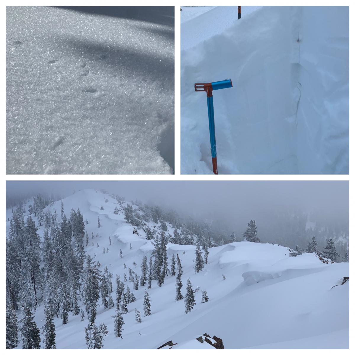
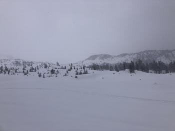
Yesterday, we finally saw sunshine and blue sky for the first time since Tuesday. Riders and sliders alike were able to step out into steeper terrain. We have not seen or received reports of major recent avalanches, and no signs of instability, both on Mount Shasta and in the Eddy Mountains. That said, a few notes:
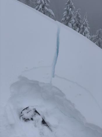
- On Thursday night, widespread surface hoar formed in low-lying areas and all the way up to ridge tops on northerly facing aspects in the Eddies and on Mt. Shasta below/near treeline. While the sun came out and melted some, by the end of the day, surface hoar still existed in avalanche starting zones. With a significant storm on the way, this classic weak layer will be buried.
- Today, a thin crust will likely be found on select southerly aspects.
- We've seen several inches of settlement in the snowpack, but several feet of unconsolidated, layered snow exists out there. With an additional large dump of snow over the weekend and strong southerly wind, we can expect the avalanche danger to spike again and large avalanches will be possible.
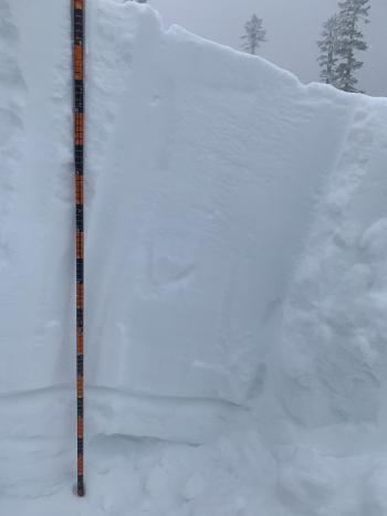
- 80 to 90 cm of new snow / 155 cm total snow height - 6,400 feet, NE aspect, Eddies / No notable stability test results.
Weather and Current Conditions
Weather Summary
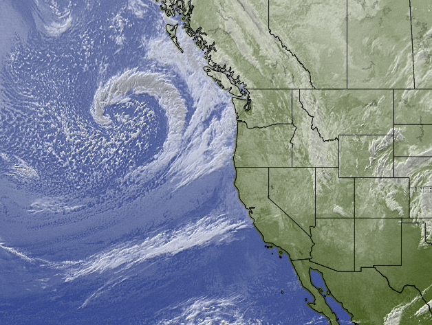
An elongated trough of low atmospheric pressure is approaching to give the area another round of significant weather late Saturday night through Tuesday. Snow levels will be higher with this storm, but we are still expecting robust amounts of new snow above 5,000 feet. Mount Shasta will experience sustained up slope flow with southerly winds of 30-50 knots between 5,000 and 10,000 feet, lasting this morning through Monday night. The current forecast calls for around a foot to eventually impact the city. We should see 1-2 inches today, several inches later tonight with a bump up in snow level, then more snow early Sunday. Snow levels may rise above city limits by Sunday afternoon. The higher mountains should easily get another 2-3 feet. After this trough moves through and southerly flow abates, cooler air will push in, and we will transition to northerly flow aloft and mainly dry conditions until Thursday night/Friday.
Old Man Winter is packing up a blow once again! Multiple hazard warnings have been issued by the NWS. Click each for details. Winter Storm Warning / Winter Weather Advisory / Winter Storm Watch
24 Hour Weather Station Data @ 4:00 AM
| Weather Station | Temp (°F) | Wind (mi/hr) | Snow (in) | Comments | ||||||||
|---|---|---|---|---|---|---|---|---|---|---|---|---|
| Cur | Min | Max | Avg | Avg | Max Gust | Dir | Depth | New | Water Equivalent | Settlement | ||
| Mt. Shasta City (3540 ft) | 34 | 29 | 37 | 32.5 | 2 | N | ||||||
| Sand Flat (6750 ft) | 24 | 18 | 31 | 24 | snow sensor broken | |||||||
| Ski Bowl (7600 ft) | 20 | 16.5 | 26 | 20 | 73 | 0 | 0.08 | 2.4 | ||||
| Gray Butte (8000 ft) | 19 | 16 | 25 | 19 | 10 | 31 | W | |||||
| Castle Lake (5870 ft) | 25 | 20 | 33 | 25.5 | 54.6 | 2.2 | 0 | |||||
| Mount Eddy (6509 ft) | 23.5 | 13 | 26.5 | 22 | 1 | 5 | SSE | 60.6 | 0 | 0.5 | ||
| Ash Creek Bowl (7250 ft) | 21.5 | 18 | 22 | 20 | 55.9 | 0 | 1.1 | |||||
| Ash Creek Ridge (7895 ft) | 19 | 11.5 | 19 | 16.5 | wind sensor now rimed |
Two Day Mountain Weather Forecast
Produced in partnership with the Medford NWS
| For 7000 ft to 9000 ft | |||
|---|---|---|---|
|
Saturday (4 a.m. to 10 p.m.) |
Saturday Night (10 p.m. to 4 a.m.) |
Sunday (4 a.m. to 10 p.m.) |
|
| Weather | Chance of snow, cloudy, breezy. Snow level near 3,600 feet. | Snow, windy. Snow level near 4,100 feet. | Snow, windy, snow level near 3,800 feet. |
| Temperature (°F) | 26 | 24 | 30 |
| Wind (mi/hr) | South 15-20 | South 15-20 | South 20-25 |
| Precipitation SWE / Snowfall (in) | 0.22 / 2-4 | 0.27 / 4-9 | 1.31 / 4-8 |
| For 9000 ft to 11000 ft | |||
| Saturday | Saturday Night | Sunday | |
| Weather | Chance of snow, cloudy, windy. | Snow, heavy at times, windy. | Snow, heavy at times, windy. |
| Temperature (°F) | 19 | 18 | 21 |
| Wind (mi/hr) | Southwest 35-45 | Southwest 50-60 | South 60-70 |
| Precipitation SWE / Snowfall (in) | 0.22 / 2-4 | 0.27 / 9-13 | 1.31 / 9-13 |
Season Precipitation for Mount Shasta City
| Period | Measured (in) | Normal (in) | Percent of Normal (%) |
|---|---|---|---|
| From Oct 1, 2025 (the wet season) | 10.67 | 21.85 | 49 |
| Month to Date (since Jun 1, 2026) | 7.09 | 6.64 | 107 |
| Year to Date (since Jan 1, 2026) | 7.09 | 6.64 | 107 |

