

You are here
Avalanche Forecast for 2021-02-05 06:22
- EXPIRED ON February 6, 2021 @ 6:22 amPublished on February 5, 2021 @ 6:22 am
- Issued by Nick Meyers - Shasta-Trinity National Forest
Bottom Line
A strong north/northwest wind event is set in place this morning. Triggering existing and newly formed wind slab avalanches and cornices is possible. Extra caution is advised if stepping out into near and above treeline avalanche terrain. Carry a beacon, shovel and probe and know how to use it.


Avalanche Problem 1: Wind Slab
-
Character ?

-
Aspect/Elevation ?
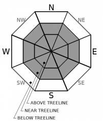
-
Likelihood ?CertainVery LikelyLikelyPossible
 Unlikely
 -
Size ?HistoricVery LargeLargeSmall

Potentially fragile slabs of wind drifted snow exist on slopes loaded by north/northwest/northeast wind. New and previously formed wind slabs could exist on any aspect today in near and above treeline terrain. Cornice features will also be sensitive to trigger. Some areas will become completely scoured to the old snow surface. Mid-slope wind loading is possible in areas of extreme wind. More sheltered areas near treeline where wind speeds are diminished might host the best wind loading conditions.
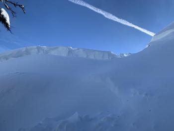
Blowing snow is one of the five red flags of avalanche danger. A clear, blue sky is not your ticket to ride. Blowing snow, corncies above a slope, wind pillows/drifts, ripples in the snow surface and scoured, windward ridges can all help identify where wind slabs may exist. Traveling in more sheltered terrain might provide better recreation conditions and help avoid the wind slab problem.
Forecast Discussion
Our most sincere condolences to the friends and family of the Etna Summit avalanche victim. I was lucky enough to share a few turns with him years ago. "They don't come much better", said another friend. And from Winnie the Pooh, "There is something you must always remember...You are braver than you believe, stronger than you seem and smarter than you think."
From the Mt Shasta Avalanche Center to all of the backcountry community... stay strong, support each other, teach each other, love each other. It's the only way.
The Everitt Memorial Highway is open. Castle Lake remains closed due to a rotary blower mechanical. The county will continue to work on opening the road. A big thank you for their efforts in keeping backcountry access free and clear.
Avalanche Awareness, tonight at 7pm via ZOOM. Companion Rescue tomorrow, Saturday. Meet at The Fifth Season in Mt Shasta City at 9am, or Bunny Flat at 9:15. Both events are free and do not require registration.
Recent Observations
- The area has received no new snow in the past 24 hours
- A northwest wind event is sweeping over the entire Northern California area. Loads of loose, blowing snow has been observed near and above treeline over all terrain.
- A skier triggered, wind slab avalanche fatality occurred just outside the forecast area near Etna Summit on February 3rd. Click here for report
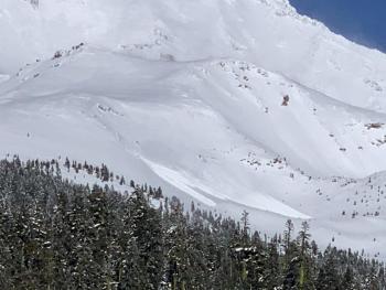
- A full width avalanche in Sun Bowl (above treeline terrain facing SW/S/SE on Mt Shasta) occurred within the last 24-48 hours. This was viewed from Bunny Flat yesterday afternoon.
- Cornices were easily triggered west of I-5 in the Eddy Mountains and "a lot of wind transport from northeasterly winds" noted one user.

Sun Bowl avalanche viewed from afar, photo taken on 02.04.21 in the late afternoon.


Weather and Current Conditions
Weather Summary
Clear skies and dry conditions are going to prevail for today and the weekend, but won't stand alone. Northwest wind is notable and forecasts are calling for near hurricane speed winds for the Summit Plateau. Lower on the mountain, still expect gale force wind speeds. The climax of the northwest wind event will occur today near the noon hour. Wind speeds will relax a bit after and expect a slow decrescendo into the weekend.
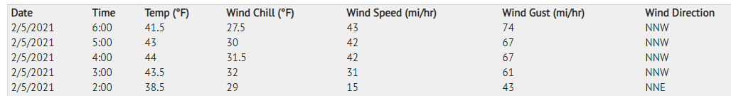
24 Hour Weather Station Data @ 4:00 AM
| Weather Station | Temp (°F) | Wind (mi/hr) | Snow (in) | Comments | ||||||||
|---|---|---|---|---|---|---|---|---|---|---|---|---|
| Cur | Min | Max | Avg | Avg | Max Gust | Dir | Depth | New | Water Equivalent | Settlement | ||
| Mt. Shasta City (3540 ft) | 32 | 28 | 44 | 35 | 3 | |||||||
| Sand Flat (6750 ft) | 33 | 13 | 34 | 27 | 186 | 0 | 0 | 0 | ||||
| Ski Bowl (7600 ft) | 45 | 19 | 48.5 | 35 | 78 | 0 | 0 | 2 | ||||
| Gray Butte (8000 ft) | 44 | 18 | 44 | 30.5 | 11 | 67 | NNW | |||||
| Castle Lake (5870 ft) | 31.5 | 19.5 | 32 | 28.5 | 68.4 | 0.7 | 0 | |||||
| Mount Eddy (6509 ft) | 38 | 22.5 | 38 | 33.5 | 3 | 8 | SSE | 68.8 | 0 | 2.6 | ||
| Ash Creek Bowl (7250 ft) | 28.5 | 15.5 | 30 | 24.5 | 58.2 | 0 | 0.8 | not responding | ||||
| Ash Creek Ridge (7895 ft) | 22.5 | 12 | 26.5 | 21 | 1 | 27 | not responding |
Two Day Mountain Weather Forecast
Produced in partnership with the Medford NWS
| For 7000 ft to 9000 ft | |||
|---|---|---|---|
|
Friday (4 a.m. to 10 p.m.) |
Friday Night (10 p.m. to 4 a.m.) |
Saturday (4 a.m. to 10 p.m.) |
|
| Weather | Sunny and windy. | Mostly clear, windy. | Sunny and windy. |
| Temperature (°F) | 35 | 31 | 39 |
| Wind (mi/hr) | Northwest/North 20-30 | North 15-25 | Northwest 20-30 |
| Precipitation SWE / Snowfall (in) | 0.00 / 0 | 0.00 / 0 | 0.00 / 0 |
| For 9000 ft to 11000 ft | |||
| Friday | Friday Night | Saturday | |
| Weather | Sunny and very windy. | Mostly clear and very windy | Sunny and very windy. |
| Temperature (°F) | 35 | 30 | 34 |
| Wind (mi/hr) | Northwest 50-60 | North 40-50 | Northwest 35-45 |
| Precipitation SWE / Snowfall (in) | 0.00 / 0 | 0.00 / 0 | 0.00 / 0 |
Season Precipitation for Mount Shasta City
| Period | Measured (in) | Normal (in) | Percent of Normal (%) |
|---|---|---|---|
| From Oct 1, 2025 (the wet season) | 12.60 | 23.24 | 54 |
| Month to Date (since Jun 1, 2026) | 1.16 | 0.97 | 120 |
| Year to Date (since Jan 1, 2026) | 9.02 | 8.03 | 112 |

