

You are here
Avalanche Forecast for 2021-02-08 06:00
- EXPIRED ON February 9, 2021 @ 6:00 amPublished on February 8, 2021 @ 6:00 am
- Issued by Ryan Sorenson - Mount Shasta Avalanche Center
Bottom Line
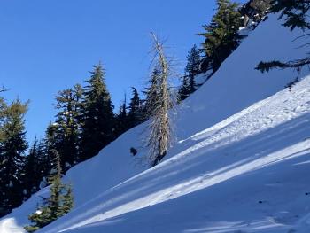
LOW avalanche danger continues with normal caution advised. Isolated wind slabs may still be found on protected leeward slopes. Cloudy skies, more wind, and cooler temperatures will keep snow surfaces firm. Firm slopes that terminate into exposed rocky patches are today's biggest hazard.


Avalanche Problem 1: Normal Caution
-
Character ?

-
Likelihood ?CertainVery LikelyLikelyPossible
 Unlikely
 -
Size ?HistoricVery LargeLargeSmall

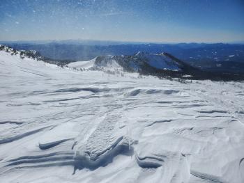
Continue to watch for isolated wind slabs in steep terrain. The northwesterly wind will continue to gouge any available snow, which at this point is minimal. So far, all wind slabs encountered have been stubborn/unreactive to trigger. Protected areas that host lighter winds could still have lingering and/or fresh wind slabs. Exercise normal caution today. The biggest hazard is a slip or fall on a firm slope that terminates into an exposed rocky patch.
Forecast Discussion
The Everitt Memorial Highway is open. The gate on Castle Lake road is open, and the county has plowed to the Methodist Camp. Please give the plow drivers space to clear the remaining snow today.
Recent Observations
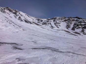
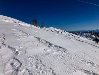
- Strong northwesterly winds have laid waste to the snowpack, scouring, packing, and stripping any exposed snow over the past few days.
- Large rocky patches have developed on ridgelines and moraine tops.
- Snow surfaces are a mixed bag of textures, including firm packed powder, wind-sculpted sastrugi, and icy patches.
- Spring-like melt-freeze conditions have been occurring on the southerly aspects at lower elevations. Winds have delayed softening.
- Gray Butte wind: Periods of strong northwesterly winds mixed with periods of light to moderate wind speeds yesterday.
- Max winds speed to 26 mi/hr, and 15 mi/hr average. Wind gusts were as high as 49 mi/hr.
- Near treeline temperatures Old Ski Bowl: Minimum: 33.5 ℉, Max: 46.5 ℉, Average: 40 ℉
Weather and Current Conditions
Weather Summary
A small blip of moisture will bring mostly cloudy skies today. No precipitation is expected. Temperatures will decrease from the high of 39 ℉. The northwesterly wind will continue to blow but not as strong as the past few days. Local variation in topography will allow for light southwesterly winds in the Eddies and at lower elevations on Mount Shasta.
Models are beginning to come to an agreement about a storm moving in on Thursday. So far, it's looking like 6 inches of snow with levels near 4,000 feet. Snow showers should continue into the weekend.
24 Hour Weather Station Data @ 6:00 AM
| Weather Station | Temp (°F) | Wind (mi/hr) | Snow (in) | Comments | ||||||||
|---|---|---|---|---|---|---|---|---|---|---|---|---|
| Cur | Min | Max | Avg | Avg | Max Gust | Dir | Depth | New | Water Equivalent | Settlement | ||
| Mt. Shasta City (3540 ft) | 30 | 27 | 59 | 40.5 | 3 | |||||||
| Sand Flat (6750 ft) | 35 | 34 | 45 | 39 | 0 | 0 | 0 | 0 | Depth sensor not working. | |||
| Ski Bowl (7600 ft) | 37 | 33.5 | 46.5 | 40 | 73.9 | 0 | 0 | 0 | ||||
| Gray Butte (8000 ft) | 35.5 | 33.5 | 43 | 38 | 15 | 49 | NW | |||||
| Castle Lake (5870 ft) | 36.5 | 34 | 50.5 | 39 | 68 | 0 | 0 | |||||
| Mount Eddy (6509 ft) | 34.5 | 31.5 | 46.5 | 39 | 2 | 6 | SE | 63.8 | 0 | 1.3 | ||
| Ash Creek Bowl (7250 ft) | 30 | 28 | 41 | 33.5 | 55.2 | 0 | 0.7 | |||||
| Ash Creek Ridge (7895 ft) | 29.5 | 28.5 | 37 | 31 | 16 | 27 | W | wind sensor rimed |
Two Day Mountain Weather Forecast
Produced in partnership with the Medford NWS
| For 7000 ft to 9000 ft | |||
|---|---|---|---|
|
Monday (4 a.m. to 10 p.m.) |
Monday Night (10 p.m. to 4 a.m.) |
Tuesday (4 a.m. to 10 p.m.) |
|
| Weather | Mostly cloudy | Partly cloudy | Mostly Sunny |
| Temperature (°F) | 39 | 26 | 39 |
| Wind (mi/hr) | Southwest 5-10 | Southwest 5-10 | West 5-10 |
| Precipitation SWE / Snowfall (in) | 0.00 / 0 | 0.00 / 0 | 0.00 / 0 |
| For 9000 ft to 11000 ft | |||
| Monday | Monday Night | Tuesday | |
| Weather | Mostly Cloudy | Partly cloudy | Mostly sunny |
| Temperature (°F) | 28 | 21 | 24 |
| Wind (mi/hr) | Northwest 25-30 | West 20-25 | Northwest 15-20 |
| Precipitation SWE / Snowfall (in) | 0.00 / 0 | 0.00 / 0 | 0.00 / 0 |
Season Precipitation for Mount Shasta City
| Period | Measured (in) | Normal (in) | Percent of Normal (%) |
|---|---|---|---|
| From Oct 1, 2025 (the wet season) | 12.60 | 23.97 | 53 |
| Month to Date (since Jun 1, 2026) | 1.16 | 1.70 | 68 |
| Year to Date (since Jan 1, 2026) | 9.02 | 8.76 | 103 |

