

You are here
Avalanche Forecast for 2021-02-09 06:15
- EXPIRED ON February 10, 2021 @ 6:15 amPublished on February 9, 2021 @ 6:15 am
- Issued by Aaron Beverly - Mount Shasta Avalanche Center
Bottom Line
Avalanche danger is low. Normal caution is advised. Expect firm conditions above treeline.


Avalanche Problem 1: Normal Caution
-
Character ?

-
Likelihood ?CertainVery LikelyLikelyPossible
 Unlikely
 -
Size ?HistoricVery LargeLargeSmall

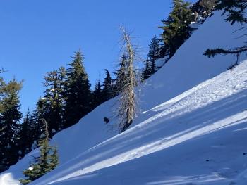
Always bring your situational awareness to the backcountry. Identify potential hazards as you travel. Be prepared for slide-for-life conditions if ascending steep terrain. Have your ice axe, crampons, and helmet. Know that self-arrest will be difficult.
Recent Observations
Over the last 24 hours on Mount Shasta, temperatures have averaged 34 ºF, peaking at 40.5 around 1 p.m. West/northwest winds have averaged 12 mi/hr, gusting up to 31. Snow depth is 73 inches.
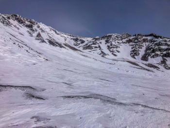
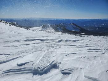
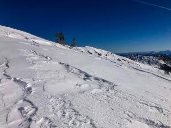
Above treeline, the snow did not soften yesterday. Snow surfaces consist of large, chalky sustrugis and firm crusts. Wind exposed moraines and ridgelines are becoming more scoured and some rock fall has been observed.
Weather and Current Conditions
Weather Summary
Temperature swings will probably not vary enough to get us a good melt-freeze cycle today. Until Thursday, expect mostly clear skies, day time temperatures in the 20s and 30s, and light to moderate west to northwest winds.
24 Hour Weather Station Data @ 5:00 AM
| Weather Station | Temp (°F) | Wind (mi/hr) | Snow (in) | Comments | ||||||||
|---|---|---|---|---|---|---|---|---|---|---|---|---|
| Cur | Min | Max | Avg | Avg | Max Gust | Dir | Depth | New | Water Equivalent | Settlement | ||
| Mt. Shasta City (3540 ft) | 30 | 27 | 50 | 38 | 0 | N | ||||||
| Sand Flat (6750 ft) | 26 | 26 | 43 | 35 | 0 | 0 | ||||||
| Ski Bowl (7600 ft) | 26 | 26 | 40.5 | 33.5 | 72.7 | 0 | 0 | 1.1 | ||||
| Gray Butte (8000 ft) | 25.5 | 25.5 | 37.5 | 32 | 12 | 31 | WNW | |||||
| Castle Lake (5870 ft) | 32 | 30 | 49 | 38.5 | 59.6 | 0 | 8.5 | |||||
| Mount Eddy (6509 ft) | 27.5 | 25.5 | 42.5 | 34 | 2 | 4 | WSW | 62.6 | 0 | 1.1 | ||
| Ash Creek Bowl (7250 ft) | 24.5 | 24.5 | 39.5 | 32 | 54.6 | 0 | 0.4 | |||||
| Ash Creek Ridge (7895 ft) | 24.5 | 24.5 | 35 | 29.5 | 8 | 20 | W |
Two Day Mountain Weather Forecast
Produced in partnership with the Medford NWS
| For 7000 ft to 9000 ft | |||
|---|---|---|---|
|
Tuesday (4 a.m. to 10 p.m.) |
Tuesday Night (10 p.m. to 4 a.m.) |
Wednesday (4 a.m. to 10 p.m.) |
|
| Weather | Mostly sunny. | Partly cloudy. | Mostly sunny. |
| Temperature (°F) | 37 | 26 | 35 |
| Wind (mi/hr) | Northwest 5-10 | Northwest 5-10 | Northwest 10-15 |
| Precipitation SWE / Snowfall (in) | 0.00 / 0 | 0.00 / 0 | 0.00 / 0 |
| For 9000 ft to 11000 ft | |||
| Tuesday | Tuesday Night | Wednesday | |
| Weather | Mostly sunny. Windy. | Partly cloudy. Blustery. | Mostly sunny. Windy. |
| Temperature (°F) | 26 | 23 | 24 |
| Wind (mi/hr) | West 20-30 | Northwest 15-20 | Northwest 20-30 |
| Precipitation SWE / Snowfall (in) | 0.00 / 0 | 0.00 / 0 | 0.00 / 0 |
Season Precipitation for Mount Shasta City
| Period | Measured (in) | Normal (in) | Percent of Normal (%) |
|---|---|---|---|
| From Oct 1, 2025 (the wet season) | 12.60 | 24.22 | 52 |
| Month to Date (since Jun 1, 2026) | 1.16 | 1.95 | 59 |
| Year to Date (since Jan 1, 2026) | 9.02 | 9.01 | 100 |

