

You are here
Avalanche Forecast for 2021-02-11 05:30
- EXPIRED ON February 12, 2021 @ 5:30 amPublished on February 11, 2021 @ 5:30 am
- Issued by Aaron Beverly - Mount Shasta Avalanche Center
Bottom Line
An incoming storm will create moderate avalanche danger above treeline. Human triggered avalanches will become possible. Wet conditions will keep avalanche danger low near and below treeline, but pay attention to changing conditions as you ascend. Evaluate terrain and snow carefully as snow begins to accumulate and blow around.


Avalanche Problem 1: Wind Slab
-
Character ?

-
Aspect/Elevation ?
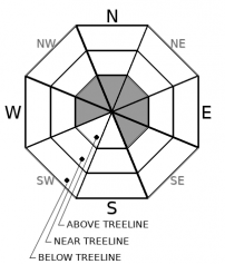
-
Likelihood ?CertainVery LikelyLikelyPossible
 Unlikely
 -
Size ?HistoricVery LargeLargeSmall

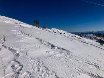
Snow levels are high and temperatures won't drop below freezing until 7,000 ft. Up to 6 inches of snow could fall at high elevations and will sit atop firm surfaces. As you transition from near to above treeline, begin paying attention to winds and blowing snow. Small wind slabs could start to form later in the day on leeward slopes.
Productive south and southwest winds will make places like the upper bowls of Castle Lake, Sun Bowl, Powder Bowl, Casaval Ridge, and the east facing ridge of Gray Butte suspect zones. These are examples. Pay attention to where wind loading is occurring and evaluate terrain and snow carefully. Human triggered avalanches will become possible.
Recent Observations
Over the last 24 hours on Mount Shasta, temperatures have averaged 33 ºF, peaking at 40.5 around 2 p.m. West/northwest winds have averaged 11 mi/hr, gusting up to 31. Snow depth is 71.5 inches.
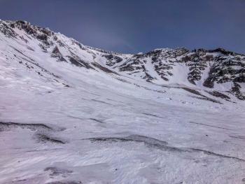
There is little, if any, snow available for transport above treeline. It all blew to the nether regions of the world. Snow surfaces consist of large, chalky sustrugis and firm crusts. Wind exposed moraines and ridgelines have become more scoured and some rock fall has been observed.
Though sun exposed aspects of Castle Lake softened nicely for skiers yesterday, widespread smooth surfaces probably firmed up last night in the near freezing temperatures.
Weather and Current Conditions
Weather Summary
Up to 6 inches of snow could fall at high elevations today. Snow levels are starting at 5,800 ft and won't drop until most of the precipitation has come. South/southwest winds will be light to moderate. Temperatures will transition to below freezing above 7,000 ft.
Periods of snow are expected throughout the weekend.
24 Hour Weather Station Data @ 5:00 AM
| Weather Station | Temp (°F) | Wind (mi/hr) | Snow (in) | Comments | ||||||||
|---|---|---|---|---|---|---|---|---|---|---|---|---|
| Cur | Min | Max | Avg | Avg | Max Gust | Dir | Depth | New | Water Equivalent | Settlement | ||
| Mt. Shasta City (3540 ft) | 35 | 29 | 54 | 40 | 2 | N | ||||||
| Sand Flat (6750 ft) | 30 | 29 | 41 | 35 | ||||||||
| Ski Bowl (7600 ft) | 28.5 | 27 | 40.5 | 32.5 | 71.4 | 0 | 0 | 0.5 | ||||
| Gray Butte (8000 ft) | 28 | 28 | 39.5 | 31.5 | 11 | 31 | WNW | |||||
| Castle Lake (5870 ft) | 33 | 30.5 | 44 | 36.5 | 59.8 | 0 | 6.5 | |||||
| Mount Eddy (6509 ft) | 33 | 29 | 40 | 34 | 2 | 6 | WSW | 60.7 | 0 | 0.7 | ||
| Ash Creek Bowl (7250 ft) | 32 | 28.5 | 39 | 32 | 53.5 | 0 | 0.3 | |||||
| Ash Creek Ridge (7895 ft) | 29.5 | 25.5 | 33 | 29 | 10 | 23 | WSW |
Two Day Mountain Weather Forecast
Produced in partnership with the Medford NWS
| For 7000 ft to 9000 ft | |||
|---|---|---|---|
|
Thursday (4 a.m. to 10 p.m.) |
Thursday Night (10 p.m. to 4 a.m.) |
Friday (4 a.m. to 10 p.m.) |
|
| Weather | Snow, mainly after 10 a.m. Chance of precipitation is 100%. | Snow showers. Chance of precipitation is 100%. | A slight chance of snow showers before 10 a.m., then a slight chance of snow after 4 p.m. Partly sunny. Chance of precipitation is 20%. |
| Temperature (°F) | 33 | 24 | 34 |
| Wind (mi/hr) | South 10-15 | Southwest 10-15 | Northwest 5-10 |
| Precipitation SWE / Snowfall (in) | 0.60 / 1-3 | 0.01 / 0-0.50 | 0.00 / 0 |
| For 9000 ft to 11000 ft | |||
| Thursday | Thursday Night | Friday | |
| Weather | Snow, mainly after 10 a.m. The snow could be heavy at times. Windy. Chance of precipitation is 100%. | Snow showers. Chance of precipitation is 100%. | A slight chance of snow showers before 10 a.m., then a slight chance of snow after 4 p.m. Partly sunny. Blustery. Chance of precipitation is 20%. |
| Temperature (°F) | 28 | 20 | 27 |
| Wind (mi/hr) | Southwest 20-25 | Southwest 20-25 | Northwest 15-20 |
| Precipitation SWE / Snowfall (in) | 0.60 / 3-6 | 0.01 / 0-0.50 | 0.00 / 0 |
Season Precipitation for Mount Shasta City
| Period | Measured (in) | Normal (in) | Percent of Normal (%) |
|---|---|---|---|
| From Oct 1, 2025 (the wet season) | 12.60 | 24.69 | 51 |
| Month to Date (since Jun 1, 2026) | 1.16 | 2.42 | 48 |
| Year to Date (since Jan 1, 2026) | 9.02 | 9.48 | 95 |

