

You are here
Avalanche Forecast for 2021-02-12 06:28
- EXPIRED ON February 13, 2021 @ 6:28 amPublished on February 12, 2021 @ 6:28 am
- Issued by Nick Meyers - Shasta-Trinity National Forest
Bottom Line
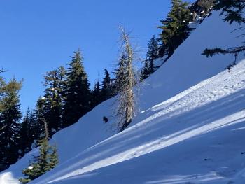
While avalanche activity remains unlikely today, expect increasing danger as a modest winter storm brings new snow and wind to the region. Travel with normal caution but expect changing conditions tonight into tomorrow morning. Fresh wind slabs will be the primary avalanche problem near and above treeline. Existing snow surfaces are smooth and firm. Watch for wind blowing snow and tread lightly near the tops of wind loaded bowls, ridgelines and in extreme terrain.


Avalanche Problem 1: Wind Slab
-
Character ?

-
Aspect/Elevation ?
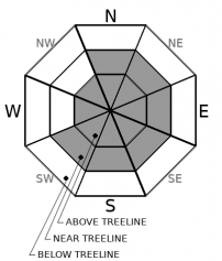
-
Likelihood ?CertainVery LikelyLikelyPossible
 Unlikely
 -
Size ?HistoricVery LargeLargeSmall

As new snow and wind begin this afternoon/evening, the avalanche danger will increase. The 3 inches of new, wet snow from the past 24 hours should not be enough to produce a large avalanche, but additional snowfall and wind will start to form more significant areas of wind drifted snow near ridgelines, in gullies and other open slopes exposed to wind. Expect the size and distribution of wind slabs to grow during the night as snow and wind impact the region. Wind will blow primarily out of the NW/W/SW.
When you transition from below to near and above treeline terrain, pay attention to winds and blowing snow. Look where wind loading is occurring and evaluate terrain and snow carefully. Human triggered avalanches are possible.
Recent Observations
Over the last 24 hours on Mount Shasta, temperatures have averaged 26 ºF, peaking at 30° F around 9 a.m. yesterday and bottoming out at 18.5° F early this morning. Predominantly west winds have averaged 11 mi/hr, gusting up to 31. Snow depth is 74 inches with 3 inches of new snow on Mount Shasta, less on the west side.
A public observation yesterday morning via a tour of Green Butte observed rain up to 7,600 feet and light wind out of the south/southeast. Snow levels dropped to near 6,500 feet by 1100 hours with trace amounts of snow on the ground. New snow was sticking well to old snow surfaces. Boot penetration below treeline was shin to knee-high. Visibility only a few hundred feet. No obvious signs of avalanche danger were noted.
Weather and Current Conditions
Weather Summary
A Winter Weather Advisory has been issued for Southeast Siskiyou County in effect from 10PM this evening to 10AM PST Saturday above 4,500 feet. An area of low pressure is digging southeastward across the state this morning and will leave mostly clear skies for the day. An active pattern will continue with the next frontal boundary arriving this afternoon bringing gusty winds and periods of moderate to heavy precipitation above 5,000 feet for tonight. Snow levels will drop to near 3,500 feet on Saturday after the front passes through. A stronger system will be moving into the area Sunday night.
24 Hour Weather Station Data @ 4:00 AM
| Weather Station | Temp (°F) | Wind (mi/hr) | Snow (in) | Comments | ||||||||
|---|---|---|---|---|---|---|---|---|---|---|---|---|
| Cur | Min | Max | Avg | Avg | Max Gust | Dir | Depth | New | Water Equivalent | Settlement | ||
| Mt. Shasta City (3540 ft) | 34 | 32 | 44 | 38 | 2 | N | ||||||
| Sand Flat (6750 ft) | 23 | 21 | 33 | 30 | ||||||||
| Ski Bowl (7600 ft) | 18.5 | 18.5 | 30 | 26.5 | 74.3 | 2.9 | 0.52 | 0 | ||||
| Gray Butte (8000 ft) | 18.5 | 18.5 | 29.5 | 26 | 12 | 31 | W | |||||
| Castle Lake (5870 ft) | 26.5 | 26.5 | 35 | 31.5 | 60.6 | 0.8 | 0 | |||||
| Mount Eddy (6509 ft) | 24.5 | 17.5 | 36 | 30 | 1 | 3 | 61.8 | 1.1 | 0 | |||
| Ash Creek Bowl (7250 ft) | 22.5 | 20.5 | 32 | 28 | 55.9 | 2.4 | 0 | |||||
| Ash Creek Ridge (7895 ft) | 19 | 18.5 | 29.5 | 25 | 3 | 36 |
Two Day Mountain Weather Forecast
Produced in partnership with the Medford NWS
| For 7000 ft to 9000 ft | |||
|---|---|---|---|
|
Friday (4 a.m. to 10 p.m.) |
Friday Night (10 p.m. to 4 a.m.) |
Saturday (4 a.m. to 10 p.m.) |
|
| Weather | Partly sunny, increasing clouds in afternoon. Chance of snow after 4p.m. Snow level near 4,300 feet | Cloudy. Snow likely, snow level near 5,300 feet. | Breezy, mostly cloudy with chance of snow |
| Temperature (°F) | 33 | 31 | 29 |
| Wind (mi/hr) | Northwest 10-15 | Southwest 10-15 | Northwest 10-15 |
| Precipitation SWE / Snowfall (in) | 0.03 / 0-0.50 | 0.17 / 2-4 | 0.30 / 1-3 |
| For 9000 ft to 11000 ft | |||
| Friday | Friday Night | Saturday | |
| Weather | Partly sunny, windy. Increasing clouds and a chance of snow after 4p.m. | Snow and windy. | Snow showers tapering, windy. |
| Temperature (°F) | 25 | 10 | 10 |
| Wind (mi/hr) | Northwest 15-25 | West 25-35 | West 25-35 |
| Precipitation SWE / Snowfall (in) | 0.03 / 0-0.50 | 0.17 / 3-5 | 0.30 / 2-4 |
Season Precipitation for Mount Shasta City
| Period | Measured (in) | Normal (in) | Percent of Normal (%) |
|---|---|---|---|
| From Oct 1, 2025 (the wet season) | 12.77 | 24.93 | 51 |
| Month to Date (since Jul 1, 2026) | 1.33 | 2.66 | 50 |
| Year to Date (since Jan 1, 2026) | 9.19 | 9.72 | 95 |

