

You are here
Avalanche Forecast for 2021-02-15 06:25
- EXPIRED ON February 16, 2021 @ 6:25 amPublished on February 15, 2021 @ 6:25 am
- Issued by Ryan Sorenson - Mount Shasta Avalanche Center
Bottom Line
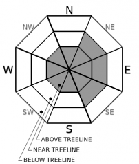
Strong west/northwest wind will set in place today as the storm clears out. It's best to give the snowpack time to settle. Existing and fresh wind slabs are resting on top of lower density snow that is slow to bond to underlying layers. Triggering existing and newly formed wind slab avalanches and cornices is possible. Natural avalanches remain possible above treeline. CONSIDERABLE avalanche danger remains for above treeline terrain, MODERATE danger exists near treeline, and LOW danger exists below treeline.


Avalanche Problem 1: Wind Slab
-
Character ?

-
Aspect/Elevation ?
-
Likelihood ?CertainVery LikelyLikelyPossible
 Unlikely
 -
Size ?HistoricVery LargeLargeSmall

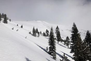
We've received approximately 4 inches of fresh snow in the last 24 hours. Potentially fragile slabs of wind drifted snow will remain on slopes loaded by west/northwest winds. The existing firm slabs over weaker softer snow are slow to bond to the underlying crusts. Wind slabs yesterday were stubborn in some places and reactive in others. Slightly wetter and heavier snow fell last night. Expect existing and fresh wind slabs to remain reactive on steep loaded slopes above treeline. Northwesterly winds will increase as the storm clears today. New and existing slabs will be small to large sized. Loaded NE-E-SE aspects are most suspect; however, local topography variations can affect a slope's wind speed, direction, and loading characteristics. Warmer temperatures have allowed the existing snowpack to settle at lower elevations and decreased the likelihood of triggering. Natural avalanches remain possible and human triggers likely on the loaded above treeline terrain. Human triggered avalanches are possible in near treeline terrain.
Even though skies may clear today, dangerous wind slab avalanche conditions will linger. Look for clues such as blowing snow, cornices over slopes, ripples on the snow surface, and hollow sounding snow as you travel in safe terrain. Extra caution is advised if stepping out into near and above treeline avalanche terrain. Carry a beacon, shovel, and probe and know how to use it.
Recent Observations
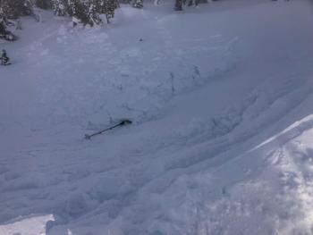
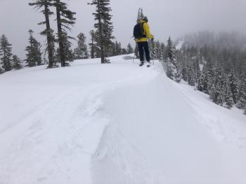
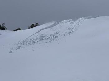
On a tour up Gray Butte and into the Old Ski Bowl yesterday, we encountered limited visibility, blowing and falling snow, small wind slabs, and places of wind drifted snow and cornices. Small test slopes on easterly aspects found various wind slabs. Some were sensitive, and others were not. Failures were within the top 3 to 6 inches of fresh snow. Loose-dry sloughs were also produced on small, steep test slopes. See complete observation and photos here.
Over the last 24 hours, our weather station at Old Ski Bowl has received 3.2 inches (8 cm) of fresh snow with 0.52 inches (13 mm) of snow water equivalent. West/northwest winds on Gray Butte were most potent during the daylight hours averaging 14 mi/hr with gusts up to 43 mi/hr. Wind speeds decreased last night. Temperatures have averaged 22 ºF, bottomed out at 16.5° F yesterday morning, and maxed out at 28° F around 5 p.m. Snow depth is currently 81.5 inches (207 cm) near treeline on Mount Shasta.
Weather and Current Conditions
Weather Summary
Colder air pushed behind the warm front allowing for lower than expected snow levels last night. The storm is beginning to wind down and move out. Cloudy skies will linger, and snow showers will remain possible throughout the day. However, the bulk of the precipitation has already fallen. Expect strong westerly winds as the storm pushes north and east.
A chance for lingering snow showers will continue through Tuesday. The majority of precipitation will stay north of our area. Chances of showers are slightly higher for the Eddies. A colder dry air mass is expected to move in on Wednesday. This will set the stage for series of storms starting Thursday.
24 Hour Weather Station Data @ 5:00 AM
| Weather Station | Temp (°F) | Wind (mi/hr) | Snow (in) | Comments | ||||||||
|---|---|---|---|---|---|---|---|---|---|---|---|---|
| Cur | Min | Max | Avg | Avg | Max Gust | Dir | Depth | New | Water Equivalent | Settlement | ||
| Mt. Shasta City (3540 ft) | 34 | 31 | 37 | 33.5 | 2 | N | ||||||
| Sand Flat (6750 ft) | 25 | 21 | 32 | 26 | 0 | 0 | 0 | 0 | ||||
| Ski Bowl (7600 ft) | 22 | 17.5 | 31.5 | 23.5 | 81.5 | 3.5 | 0.54 | 0 | ||||
| Gray Butte (8000 ft) | 21 | 16.5 | 28 | 22 | 14 | 43 | NW | |||||
| Castle Lake (5870 ft) | 26.5 | 23 | 33.5 | 27 | 11.4 | 5.4 | 0 | |||||
| Mount Eddy (6509 ft) | 35.5 | 21 | 39 | 31.5 | 2 | 6 | SE | 17 | 5.4 | 0 | ||
| Ash Creek Bowl (7250 ft) | 33.5 | 19 | 33.5 | 27.5 | 60.3 | 1.5 | 0 | |||||
| Ash Creek Ridge (7895 ft) | 30 | 15.5 | 30.5 | 25 | 0 | 0 |
Two Day Mountain Weather Forecast
Produced in partnership with the Medford NWS
| For 7000 ft to 9000 ft | |||
|---|---|---|---|
|
Monday (4 a.m. to 10 p.m.) |
Monday Night (10 p.m. to 4 a.m.) |
Tuesday (4 a.m. to 10 p.m.) |
|
| Weather | Mostly cloudy. Snow in the morning then a chance of snow showers in the afternoon. Snow levels near 5,200 feet. | Windy. Partly cloudy with a 30 percent chance of snow showers. Snow levels near 3,700 feet. | Breezy. Mostly cloudy in the morning then becoming partly cloudy. Slight chance of snow showers. Snow levels near town. |
| Temperature (°F) | 38 | 21 | 33 |
| Wind (mi/hr) | Southwest 10-20 | West 5-10 | Northwest 10-15 |
| Precipitation SWE / Snowfall (in) | 0.06 / 0-1 | 0.00 / 0-1 | 0.00 / 0-1 |
| For 9000 ft to 11000 ft | |||
| Monday | Monday Night | Tuesday | |
| Weather | Mostly cloudy. Snow in the morning then a chance of snow showers in the afternoon. | Windy. Partly cloudy with a 30 percent chance of snow showers. | Breezy. Mostly cloudy in the morning then becoming partly cloudy. Slight chance of snow showers. |
| Temperature (°F) | 22 | 13 | 16 |
| Wind (mi/hr) | West 45-50 | Northwest 45-50 | Northwest 45-50 |
| Precipitation SWE / Snowfall (in) | 0.06 / 0-1 | 0.00 / 0-1 | 0.00 / 0-1 |
Season Precipitation for Mount Shasta City
| Period | Measured (in) | Normal (in) | Percent of Normal (%) |
|---|---|---|---|
| From Oct 1, 2025 (the wet season) | 13.24 | 25.67 | 52 |
| Month to Date (since Jul 1, 2026) | 1.80 | 3.40 | 53 |
| Year to Date (since Jan 1, 2026) | 9.66 | 10.46 | 92 |

