

You are here
Avalanche Forecast for 2021-02-16 06:00
- EXPIRED ON February 17, 2021 @ 6:00 amPublished on February 16, 2021 @ 6:00 am
- Issued by Aaron Beverly - Mount Shasta Avalanche Center
Bottom Line
Avalanche danger above treeline is considerable. Strong northwest winds will continue to transport snow and load leeward slopes. Avalanche danger below treeline is low. Expect cold, windy conditions today. More precipitation is on the way early Thursday morning.


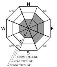
Avalanche Problem 1: Wind Slab
-
Character ?

-
Aspect/Elevation ?
-
Likelihood ?CertainVery LikelyLikelyPossible
 Unlikely
 -
Size ?HistoricVery LargeLargeSmall

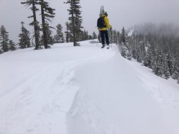
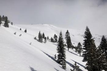
Because strong northwest winds will continue to blow today, and yesterday's winds were transporting plenty of snow, we are keeping above treeline danger levels at considerable. Winds have often led to unexpected natural avalanches long after storms have ended. This could be one of those days. Direct sun beating down upon open slopes may loosen slabs enough to slide. Sun Bowl and Powder Bowl are suspect locations for wind slabs, but any steep leeward slope should be approached with caution.
Lower elevations have probably firmed up with a melt-freeze cycle in the last 24 hours, but be careful as you transition from below to above treeline. Human triggered wind slab avalanches may still be possible.
Recent Observations
Over the last 24 hours on Mount Shasta, temperatures have averaged 25 ºF, peaking at 32.5 at 12 p.m. Northwest winds have averaged 22 mi/hr, gusting up to 55. Snow depth is 80.3 inches.
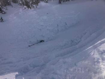
It was a windy day above treeline on Mount Shasta. Plumes of blowing snow could be seen from miles away. Those west and northwest winds always seem to be productive in moving snow around. Moraines and ridgelines have become scoured again. It is not clear how much snow is still available to transport.
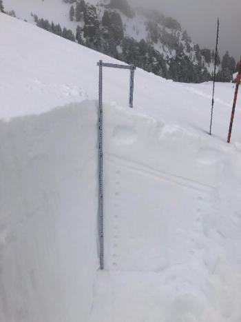
Lower elevation regions such as Castle Lake got baked in the warmer temperatures. CT, hand tests, and ski cuts indicated moderate failures in the newest snow that was becoming up-side-down in its configuration. The cornices and wind slabs at the top of middle peak were a bit stubborn to trigger, but indicated that more significant instabilities were likely to exist at higher, colder elevations.
Weather and Current Conditions
Weather Summary
If there was precipitation on the way, we'd get snow in town today. Unfortunately for snow lovers, there is no snow on deck until early Thursday morning. That storm looks to bring about 0.5 inches of water. Snow levels are looking high for that one, but let's wait another couple of days before despairing.
Temperatures will be in the teens and low 20s today and tonight. Northwest winds will be moderate to strong and may even reach gale force speeds.
24 Hour Weather Station Data @ 5:00 AM
| Weather Station | Temp (°F) | Wind (mi/hr) | Snow (in) | Comments | ||||||||
|---|---|---|---|---|---|---|---|---|---|---|---|---|
| Cur | Min | Max | Avg | Avg | Max Gust | Dir | Depth | New | Water Equivalent | Settlement | ||
| Mt. Shasta City (3540 ft) | 36 | 32 | 43 | 36 | 1 | N | ||||||
| Sand Flat (6750 ft) | 23 | 23 | 36 | 29 | ||||||||
| Ski Bowl (7600 ft) | 26.5 | 19.5 | 32.5 | 25 | 80.1 | 0 | 0.04 | 1.2 | ||||
| Gray Butte (8000 ft) | 20.5 | 17.5 | 27.5 | 22.5 | 22 | 55 | NW | |||||
| Castle Lake (5870 ft) | 23.5 | 23.5 | 43.5 | 30.5 | 65 | 7.3 | 0 | |||||
| Mount Eddy (6509 ft) | 23.5 | 23.5 | 38.5 | 30.5 | 3 | 10 | SE | 62.8 | 0 | 1.9 | ||
| Ash Creek Bowl (7250 ft) | 20 | 20 | 33.5 | 27 | 59.4 | 0 | 0.9 | |||||
| Ash Creek Ridge (7895 ft) | 16.5 | 16.5 | 30 | 22.5 | 11 | 36 |
Two Day Mountain Weather Forecast
Produced in partnership with the Medford NWS
| For 7000 ft to 9000 ft | |||
|---|---|---|---|
|
Tuesday (4 a.m. to 10 p.m.) |
Tuesday Night (10 p.m. to 4 a.m.) |
Wednesday (4 a.m. to 10 p.m.) |
|
| Weather | Mostly sunny. | Partly cloudy. | Mostly sunny. Breezy. Low wind chills. |
| Temperature (°F) | 24 | 16 | 36 |
| Wind (mi/hr) | Northwest 10-15 | North 5-10 | North 10-15 |
| Precipitation SWE / Snowfall (in) | 0.00 / 0 | 0.00 / 0 | 0.00 / 0 |
| For 9000 ft to 11000 ft | |||
| Tuesday | Tuesday Night | Wednesday | |
| Weather | Mostly sunny. Windy. Low wind chills. | Partly cloudy. Windy. Low wind chills. | Areas of blowing snow between 10 a.m. and 1 p.m. Mostly sunnyWindy. Low wind chills. |
| Temperature (°F) | 17 | 14 | 25 |
| Wind (mi/hr) | Northwest 30-40 | Northwest 30-35 | North 35-45 |
| Precipitation SWE / Snowfall (in) | 0.00 / 0 | 0.00 / 0 | 0.00 / 0 |
Season Precipitation for Mount Shasta City
| Period | Measured (in) | Normal (in) | Percent of Normal (%) |
|---|---|---|---|
| From Oct 1, 2025 (the wet season) | 13.28 | 25.93 | 51 |
| Month to Date (since Jul 1, 2026) | 1.84 | 3.66 | 50 |
| Year to Date (since Jan 1, 2026) | 9.70 | 10.72 | 90 |

