

You are here
Avalanche Forecast for 2021-02-17 07:00
- EXPIRED ON February 18, 2021 @ 7:00 amPublished on February 17, 2021 @ 7:00 am
- Issued by Aaron Beverly - Mount Shasta Avalanche Center
Bottom Line
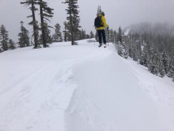
Avalanche danger above treeline is considerable. Unusually strong winds will continue to blast the forecast area. Pay attention as you transition from below to above treeline. Evaluate leeward slopes carefully.


Avalanche Problem 1: Wind Slab
-
Character ?

-
Aspect/Elevation ?
-
Likelihood ?CertainVery LikelyLikelyPossible
 Unlikely
 -
Size ?HistoricVery LargeLargeSmall

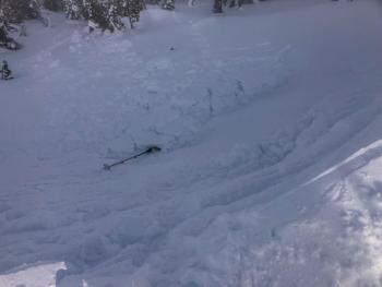
It felt like things were dropping to moderate danger yesterday, but with the unusually high wind event predicted today, we are going to keep avalanche danger considerable above treeline. These kind of wind events have often led to unexpected natural avalanches. There was enough evidence of continued wind slab formation yesterday to be concerned for the possibility of human triggered avalanches on leeward slopes. Pay attention as you transition from below to above treeline. Be conservative and evaluate the snowpack carefully today.
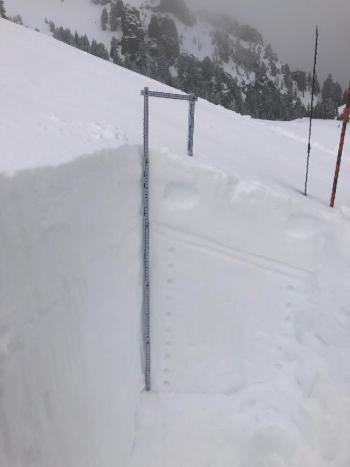
Recent Observations
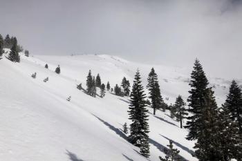
It's interesting to see how different conditions exist throughout our forecast area. On Mount Shasta yesterday, for most of the day, winds were almost calm. Ash Creek Butte, on the other hand, was wintry with moderate north winds blowing snow and forming new wind slabs.
Temperatures have been below freezing and winds have been predominantly out of the north, calm at times, light to moderate at others. Gusts have occurred up to 61 mi/hr.
Above treeline on Mount Shasta, exposed areas have become more scoured by the wind. It is unclear how much snow is still left to blow. But outlier regions, such as Ash Creek Butte, still seem to have plenty of soft, low density snow available.
Windward and less wind-effected areas around Ash Creek Butte did not reveal any concerning instabilities. Leeward, southerly facing slopes had reactive wind slabs. They were a bit stubborn to trigger on low angle well supported slopes but I suspect they would be more touchy in steep start zones.
Weather and Current Conditions
Weather Summary
Very strong winds with blizzard conditions on the upper montain are expected today due to blowing snow. When no precipitation is predicted, but blizzard conditions are forecasted, you better take notice. Leave your umbrellas at home.
Strong to gale force north winds are expected today above treeline. A bit of snow should fall tomorrow above 3,500 ft.
24 Hour Weather Station Data @ 6:00 AM
| Weather Station | Temp (°F) | Wind (mi/hr) | Snow (in) | Comments | ||||||||
|---|---|---|---|---|---|---|---|---|---|---|---|---|
| Cur | Min | Max | Avg | Avg | Max Gust | Dir | Depth | New | Water Equivalent | Settlement | ||
| Mt. Shasta City (3540 ft) | 30 | |||||||||||
| Sand Flat (6750 ft) | 19 | 17 | 30 | 23 | ||||||||
| Ski Bowl (7600 ft) | 25.5 | 17 | 30 | 25 | 78.1 | 0 | 0 | 1.5 | ||||
| Gray Butte (8000 ft) | 24.5 | 17.5 | 26.5 | 22.5 | 12 | 80 | SE | |||||
| Castle Lake (5870 ft) | 19 | 19 | 33 | 25.5 | 64.1 | 0 | 0.7 | |||||
| Mount Eddy (6509 ft) | 17 | 17 | 27 | 22.5 | 3 | 8 | SE | 61.9 | 0 | 0.9 | ||
| Ash Creek Bowl (7250 ft) | 13 | 13 | 24 | 19.5 | 58.6 | 0 | 0.6 | |||||
| Ash Creek Ridge (7895 ft) | 9.5 | 9.5 | 19 | 15.5 | wind rimed |
Two Day Mountain Weather Forecast
Produced in partnership with the Medford NWS
| For 7000 ft to 9000 ft | |||
|---|---|---|---|
|
Wednesday (4 a.m. to 10 p.m.) |
Wednesday Night (10 p.m. to 4 a.m.) |
Thursday (4 a.m. to 10 p.m.) |
|
| Weather | Sunny. | Mostly cloudy. | Snow, mainly after 11 a.m. Chance of precipitation is 90%. |
| Temperature (°F) | 35 | 23 | 27 |
| Wind (mi/hr) | North 10-15 | Northeast 5-10 | South 5-10 |
| Precipitation SWE / Snowfall (in) | 0.00 / 0 | 0.00 / 0 | 0.20 / 1-2 |
| For 9000 ft to 11000 ft | |||
| Wednesday | Wednesday Night | Thursday | |
| Weather | Sunny. Very windy. Low wind chills. | Mostly cloudy. Windy. Low wind chills. | Snow, mainly after 10 a.m. Windy. Low wind chills. Chance of precipitation is 90%. |
| Temperature (°F) | 25 | 16 | 29 |
| Wind (mi/hr) | North 40-50 | Northwest 20-30 | West 20-30 |
| Precipitation SWE / Snowfall (in) | 0.00 / 0 | 0.00 / 0 | 0.20 / 2-4 |
Season Precipitation for Mount Shasta City
| Period | Measured (in) | Normal (in) | Percent of Normal (%) |
|---|---|---|---|
| From Oct 1, 2025 (the wet season) | 13.28 | 26.21 | 51 |
| Month to Date (since Jul 1, 2026) | 1.84 | 3.94 | 47 |
| Year to Date (since Jan 1, 2026) | 9.70 | 11.00 | 88 |

