

You are here
Avalanche Forecast for 2021-03-02 05:45
- EXPIRED ON March 3, 2021 @ 5:45 amPublished on March 2, 2021 @ 5:45 am
- Issued by Aaron Beverly - Mount Shasta Avalanche Center
Bottom Line
Avalanche danger is low. Challenging conditions exist for climbers and skiers. Be prepared for firm, icy conditions above treeline. Look out for falling rock. Below treeline, a melt-freeze cycle is in effect. Winter weather returns this weekend.


Avalanche Problem 1: Normal Caution
-
Character ?

-
Likelihood ?CertainVery LikelyLikelyPossible
 Unlikely
 -
Size ?HistoricVery LargeLargeSmall

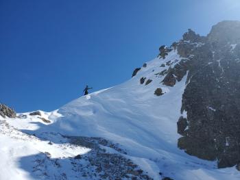
Avalanche danger is low. Falling rock and firm, icy snow surfaces are the main concern above treeline. Climbing the mountain is not recommended, but if you attempt it, bring an ice axe, crampons, and helmet.
Recent Observations
There is 71 inches of snow at 7,600 ft on Mount Shasta. In the last 24 hours, near treeline temperatures have averaged 28 ºF and peaked at 33. Below treeline temperatures peaked at 37. Measured winds have been light and southerly, though observed winds above treeline were in the moderate range.
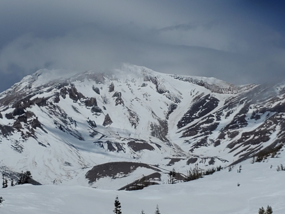
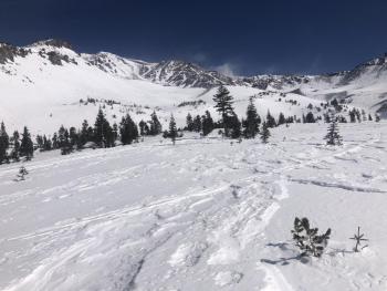
The upper mountain is bleak. Dirt and fallen rock are coloring the white brown. Climbing routes do not hold much snow. Skiers will find inconsistent conditions - firm, icy, breakable crusts, sastrugis, thin to deep moist snow. Above treeline, the snow did not soften yesterday. Cornices were rock hard. Below treeline, above Bunny Flat, popular skiing areas are tracked out.

Weather and Current Conditions
Weather Summary
A melt-freeze cycle is fully in effect - daytime temperatures in the 40s, nighttime in the 20s. This is mostly below treeline, though. Above treeline, temperatures and light to moderate south winds will work together to keep the snowpack firm. Direct sun may loosen up south and east facing aspects.
Early Saturday morning, precipitation will return and looks to continue into next week.
24 Hour Weather Station Data @ 5:00 AM
| Weather Station | Temp (°F) | Wind (mi/hr) | Snow (in) | Comments | ||||||||
|---|---|---|---|---|---|---|---|---|---|---|---|---|
| Cur | Min | Max | Avg | Avg | Max Gust | Dir | Depth | New | Water Equivalent | Settlement | ||
| Mt. Shasta City (3540 ft) | 27 | 27 | 53 | 39.5 | 1 | N | ||||||
| Sand Flat (6750 ft) | 26 | 26 | 37 | 32 | 0 | 0 | Snow sensor down | |||||
| Ski Bowl (7600 ft) | 27.5 | 25 | 33.5 | 28.5 | 33.8 | 0 | 0 | 55.1 | ||||
| Gray Butte (8000 ft) | 27 | 23.5 | 31.5 | 27 | 7 | 31 | SSE | |||||
| Castle Lake (5870 ft) | 33.5 | 28.5 | 43.5 | 34 | 60.8 | 0 | 0.9 | |||||
| Mount Eddy (6509 ft) | 27.5 | 27.5 | 37.5 | 31.5 | 2 | 6 | SW | 57.8 | 0 | 0.4 | ||
| Ash Creek Bowl (7250 ft) | 30 | 26.5 | 35 | 29.5 | 56.3 | 0 | 0.2 | |||||
| Ash Creek Ridge (7895 ft) | 26 | 23 | 30.5 | 26 | 17 | 45 | S |
Two Day Mountain Weather Forecast
Produced in partnership with the Medford NWS
| For 7000 ft to 9000 ft | |||
|---|---|---|---|
|
Tuesday (4 a.m. to 10 p.m.) |
Tuesday Night (10 p.m. to 4 a.m.) |
Wednesday (4 a.m. to 10 p.m.) |
|
| Weather | Mostly sunny. | Mostly clear. | Mostly sunny |
| Temperature (°F) | 43 | 26 | 45 |
| Wind (mi/hr) | Southeast 5-10 | South 5-10 | Southeast 5-10 |
| Precipitation SWE / Snowfall (in) | 0.00 / 0 | 0.00 / 0 | 0.00 / 0 |
| For 9000 ft to 11000 ft | |||
| Tuesday | Tuesday Night | Wednesday | |
| Weather | Mostly sunny. | Partly cloudy. | Mostly sunny. |
| Temperature (°F) | 24 | 24 | 25 |
| Wind (mi/hr) | Southwest 15-20 | South 15-20 | South 15-20 |
| Precipitation SWE / Snowfall (in) | 0.00 / 0 | 0.00 / 0 | 0.00 / 0 |
Season Precipitation for Mount Shasta City
| Period | Measured (in) | Normal (in) | Percent of Normal (%) |
|---|---|---|---|
| From Oct 1, 2025 (the wet season) | 13.58 | 29.76 | 46 |
| Month to Date (since Jul 1, 2026) | 0.00 | 0.26 | 0 |
| Year to Date (since Jan 1, 2026) | 10.00 | 14.55 | 69 |

