

You are here
Avalanche Forecast for 2021-03-08 06:00
- EXPIRED ON March 9, 2021 @ 6:00 amPublished on March 8, 2021 @ 6:00 am
- Issued by Aaron Beverly - Mount Shasta Avalanche Center
Bottom Line
Avalanche danger will increase to moderate near and above treeline as up to 9 inches of snow falls and south winds blow. Be extra cautious as you approach steep leeward slopes. By Tuesday afternoon, expect up to 15 inches of snow as you increase in elevation. Snow levels will be below town.


Avalanche Problem 1: Wind Slab
-
Character ?

-
Aspect/Elevation ?
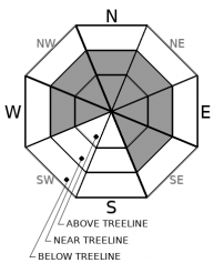
-
Likelihood ?CertainVery LikelyLikelyPossible
 Unlikely
 -
Size ?HistoricVery LargeLargeSmall

Avalanche danger will increase from low to moderate over the next 24 hours as up to 9 inches of snow falls and light to strong south winds blow. Exercise caution as you approach steep leeward slopes. Blocking, shooting cracks, and hollow snow are signs that wind slabs are forming. Human triggered avalanches will be possible.
Forecast Discussion
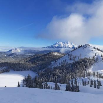
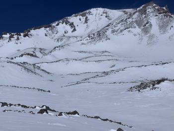
Though this week's refresh of snow is helping our beleaguered snowpack, the upper mountain still resembles late season conditions. If ascending high into the alpine, bring your ice axe, crampons, and helmet. Climbing routes are narrow and falling rock is possible.
Recent Observations
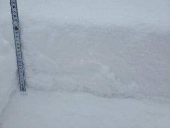
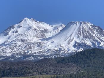
There is 69 inches of snow at 7,600 ft on Mount Shasta. In the last 24 hours, near treeline temperatures have averaged 25 ºF and peaked at 32. West/northwest winds have been light to moderate, gusting to 37.
The snow we received early Saturday morning has refreshed the snowpack but overall it has had little impact on avalanche danger. Old ski tracks and sastrugis have been filled in. Yesterday you could find a thin layer of almost corn and almost powder conditions. Some hollow wind drifts were encountered on southeast facing slopes, but they were not reactive and the new snow was bonding well with the old snow. Not much wind effect was seen above treeline. Areas exposed to direct sun softened.
Outlier regions have received more snow (6-8 inches) with wind drifts up to 12 inches. No obvious signs of avalanche danger were seen. Cold temperatures have kept new snow available for transport.
Weather and Current Conditions
Weather Summary
A baroclinic leaf cloud has apparently been affecting the area. If you don't know what this means, you are in good company. What matters is a fair amount of snow is expected over the next two days - up to 9 inches in the next 24 hours - up to 15 inches by Tuesday afternoon. South winds will range from light to strong. Snow levels will be below town. After Tuesday, we'll return to dry conditions.
24 Hour Weather Station Data @ 5:00 AM
| Weather Station | Temp (°F) | Wind (mi/hr) | Snow (in) | Comments | ||||||||
|---|---|---|---|---|---|---|---|---|---|---|---|---|
| Cur | Min | Max | Avg | Avg | Max Gust | Dir | Depth | New | Water Equivalent | Settlement | ||
| Mt. Shasta City (3540 ft) | 35 | 29 | 50 | 39.5 | 1 | N | ||||||
| Sand Flat (6750 ft) | 26 | 21 | 34 | 28 | 0 | 0 | Snow sensor down | |||||
| Ski Bowl (7600 ft) | 21 | 21 | 32 | 25.5 | 68.5 | 0 | 0.01 | 0.7 | ||||
| Gray Butte (8000 ft) | 20 | 18.5 | 29.5 | 23.5 | 6 | 37 | WNW | |||||
| Castle Lake (5870 ft) | 26.5 | 21.5 | 41 | 30.5 | 62.8 | 0 | 2.1 | |||||
| Mount Eddy (6509 ft) | 25.5 | 24 | 31.5 | 27 | 1 | 5 | ESE | 61.8 | 0 | 0.6 | ||
| Ash Creek Bowl (7250 ft) | 22 | 20 | 33.5 | 25.5 | 58.8 | 0 | 0.5 | |||||
| Ash Creek Ridge (7895 ft) | 19 | 15.5 | 34.5 | 22.5 | 5 | 26 | SSW |
Two Day Mountain Weather Forecast
Produced in partnership with the Medford NWS
| For 7000 ft to 9000 ft | |||
|---|---|---|---|
|
Monday (4 a.m. to 10 p.m.) |
Monday Night (10 p.m. to 4 a.m.) |
Tuesday (4 a.m. to 10 p.m.) |
|
| Weather | Snow likely, mainly after 10 a.m. The snow could be heavy at times. Mostly cloudy. Chance of precipitation is 60%. | Snow likely, mainly before 10 p.m. The snow could be heavy at times. Mostly cloudy. Chance of precipitation is 60%. | Snow, mainly after 10 a.m. The snow could be heavy at times. Chance of precipitation is 80%. |
| Temperature (°F) | 25 | 19 | 25 |
| Wind (mi/hr) | South 10-15 | South 10-15 | South 10-15 |
| Precipitation SWE / Snowfall (in) | 0.29 / 3-5 | 0.09 / 1-2 | 0.31 / 3-5 |
| For 9000 ft to 11000 ft | |||
| Monday | Monday Night | Tuesday | |
| Weather | Snow showers likely, mainly after 10 a.m. Mostly cloudy and cold. Windy. Low wind chills. Chance of precipitation is 70%. | Snow showers likely. Mostly cloudy. Windy. Low wind chills. Chance of precipitation is 70%. | Snow showers. Windy. Low wind chills. Chance of precipitation is 90%. |
| Temperature (°F) | 12 | 7 | 10 |
| Wind (mi/hr) | Southwest 30-40 | Southwest 25-35 | Southwest 25-35 |
| Precipitation SWE / Snowfall (in) | 0.29 / 4-6 | 0.09 / 1-2 | 0.31 / 4-6 |
Season Precipitation for Mount Shasta City
| Period | Measured (in) | Normal (in) | Percent of Normal (%) |
|---|---|---|---|
| From Oct 1, 2025 (the wet season) | 14.07 | 31.23 | 45 |
| Month to Date (since Jun 1, 2026) | 0.49 | 1.73 | 28 |
| Year to Date (since Jan 1, 2026) | 10.49 | 16.02 | 65 |

