

You are here
Avalanche Forecast for 2021-03-10 07:00
- EXPIRED ON March 11, 2021 @ 7:00 amPublished on March 10, 2021 @ 7:00 am
- Issued by Aaron Beverly - Mount Shasta Avalanche Center
Bottom Line
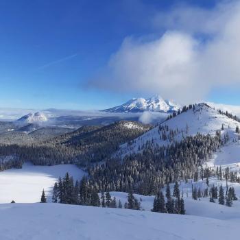
Avalanche danger is considerable. The storm is breaking, but there is a lot of new snow out there. It's added weight to the snowpack. Wind slabs have been forming and could continue to form. Use extra caution if traveling near or in avalanche terrain. Human-triggered avalanches will be likely.


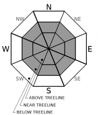
Avalanche Problem 1: Wind Slab
-
Character ?

-
Aspect/Elevation ?
-
Likelihood ?CertainVery LikelyLikelyPossible
 Unlikely
 -
Size ?HistoricVery LargeLargeSmall

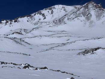
About 26 inches of new, light snow is out there available for transport. A few more could fall today. Wind loading was occurring yesterday near treeline. Winds are tapering off today, but it doesn't take much to produce wind slabs. They could be increasing in size. Be extra cautious near steep, leeward terrain. Slabs may sit atop a slick crust that is breakable above a weak layer of snow from Saturday. They could be really big.
Human triggered avalanches are likely. Pay attention to these signs: whumphing sounds, shooting cracks, and hollow snow. If you see or experience these things, winds slabs are nearby.
Avalanche Problem 2: Storm Slab
-
Character ?

-
Aspect/Elevation ?
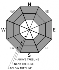
-
Likelihood ?CertainVery LikelyLikelyPossible
Unlikely
-
Size ?HistoricVery LargeLargeSmall
The concern for storm slabs is diminishing. The problem is short lived. But some signs of them were seen yesterday afternoon. Be cautious on steep, wind protected slopes. Human-triggered storm slabs are possible.
Storm Slabs form when new snow consolidates over a weaker layer or interface. The weak point can be snow that fell early in the storm or just a poor bond with the old snow surface.
Forecast Discussion
The weak layer that exists within the storm snow from Saturday is something to keep an eye on. Look for it as you transition above treeline. It wasn't a concern at below treeline elevations. That layer lies between two crusts and is not well bonded to the crust it sits on. Pay attention to this over the next few days. Cold temperatures will not allow it to strengthen and could cause facets to form.
Recent Observations
There is 97 inches of snow at 7,600 ft on Mount Shasta. In the last 24 hours, 16 inches of light snow has fallen near treeline. South/southeast winds have averaged 8 mi/hr and gusted up to 31. The mean temperature has been 18 ºF.
Fifteen inches of new snow is being reported at Castle Lake.
The weak layer discovered Monday at the top of Gray Butte does not exist below treeline. You will find the crust over crust configuration everywhere but the weakness between the crusts will most likely exist at near and above treeline elevations where the snowpack was exposed to colder temperatures and direct sun.
Weather and Current Conditions
Weather Summary
A winter storm warning remains in effect until 10 a.m.
We may get up to 3 inches more out of the lingering storm. Snow levels will remain near Dunsmuir. Southwest winds will be light to moderate.
Clear, warm, dry conditions will settle in until Sunday.
24 Hour Weather Station Data @ 6:00 AM
| Weather Station | Temp (°F) | Wind (mi/hr) | Snow (in) | Comments | ||||||||
|---|---|---|---|---|---|---|---|---|---|---|---|---|
| Cur | Min | Max | Avg | Avg | Max Gust | Dir | Depth | New | Water Equivalent | Settlement | ||
| Mt. Shasta City (3540 ft) | 29 | 29 | 35 | 32 | 2 | N | ||||||
| Sand Flat (6750 ft) | 20 | 20 | 26 | 22 | Snow sensor down | |||||||
| Ski Bowl (7600 ft) | 15.5 | 15 | 21.5 | 17.5 | 97.2 | 18.1 | 1.5 | 0 | ||||
| Gray Butte (8000 ft) | 14.5 | 14.5 | 19.5 | 16.5 | 8 | 31 | SSE | |||||
| Castle Lake (5870 ft) | 20 | 20 | 30 | 23.5 | 15 | 0 | 51.8 | |||||
| Mount Eddy (6509 ft) | 18 | 18 | 24 | 21 | 1 | 4 | SW | 76.5 | 13.3 | 0 | ||
| Ash Creek Bowl (7250 ft) | 18.5 | 16.5 | 20.5 | 18.5 | 76 | 8.3 | 0 | |||||
| Ash Creek Ridge (7895 ft) | 13.5 | 13 | 18.5 | 15 | wind sensor rimed |
Two Day Mountain Weather Forecast
Produced in partnership with the Medford NWS
| For 7000 ft to 9000 ft | |||
|---|---|---|---|
|
Wednesday (4 a.m. to 10 p.m.) |
Wednesday Night (10 p.m. to 4 a.m.) |
Thursday (4 a.m. to 10 p.m.) |
|
| Weather | Snow showers likely, mainly before 5 p.m. Cloudy, then gradually becoming mostly sunny. Chance of precipitation is 70%. | Scattered snow showers before 11 p.m. Partly cloudy. Chance of precipitation is 30%. | Mostly sunny. |
| Temperature (°F) | 26 | 23 | 17 |
| Wind (mi/hr) | South 5-10 | Northwest 5-10 | North 5-10 |
| Precipitation SWE / Snowfall (in) | 0.11 / 0.50-2 | 0.00 / 0 | 0.00 / 0 |
| For 9000 ft to 11000 ft | |||
| Wednesday | Wednesday Night | Thursday | |
| Weather | Snow showers likely, mainly before 5 p.m. Mostly cloudy and cold. Chance of precipitation is 70%. | Scattered snow showers before 11 p.m. Partly cloudy. Blustery. Chance of precipitation is 30%. | Patchy blowing snow after 5 p.m. Mostly sunny. |
| Temperature (°F) | 10 | 10 | 15 |
| Wind (mi/hr) | Southwest 5-10 | Northeast 15-20 | Northeast 15-20 |
| Precipitation SWE / Snowfall (in) | 0.11 / 1-3 | 0.00 / 0 | 0.00 / 0 |
Season Precipitation for Mount Shasta City
| Period | Measured (in) | Normal (in) | Percent of Normal (%) |
|---|---|---|---|
| From Oct 1, 2025 (the wet season) | 15.06 | 31.69 | 48 |
| Month to Date (since Jun 1, 2026) | 1.48 | 2.19 | 68 |
| Year to Date (since Jan 1, 2026) | 11.48 | 16.48 | 70 |

