

You are here
Avalanche Forecast for 2021-03-11 06:15
- EXPIRED ON March 12, 2021 @ 6:15 amPublished on March 11, 2021 @ 6:15 am
- Issued by Aaron Beverly - Mount Shasta Avalanche Center
Bottom Line
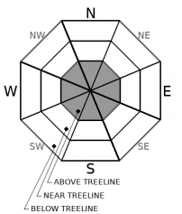
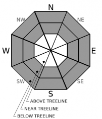
Avalanche danger is considerable above treeline. It's moderate near and below. Wind slabs and storm slabs could still be triggered by human interaction. Evaluate snow and terrain carefully today. Wind, sun, and temperatures could turn the ample amount of light snow into avalanche problems.


Avalanche Problem 1: Wind Slab
-
Character ?

-
Aspect/Elevation ?
-
Likelihood ?CertainVery LikelyLikelyPossible
 Unlikely
 -
Size ?HistoricVery LargeLargeSmall

We got 30 inches of snow since Monday. That's a lot. Winds near and below treeline have not seemed to be very productive in moving it around. High elevations above treeline could be a different story. We have not been able to get up there yet.
Winds are hard to predict on Mount Shasta. You can't always rely on the forecasts. Based on the forecasts, though, I'd say wind slab danger could be considerable above treeline. But pay attention as you ascend. Do you see blowing snow? Do you see shooting cracks or blocking as you travel over wind drifts? If you do, know that wind slabs are lurking out there on steep leeward slopes.
Avalanche Problem 2: Storm Slab
-
Character ?

-
Aspect/Elevation ?
-
Likelihood ?CertainVery LikelyLikelyPossible
Unlikely
-
Size ?HistoricVery LargeLargeSmall
Storm slabs are short lived and I'd I normally take this problem off the list. But warming temperatures and sunny weather today could create an up-side-down configuration in the snowpack. A cohesive layer may develop over the soft snow beneath. Be cautious on very steep slopes. Roller balls and pinwheels are an indication that the upper snowpack is becoming "slabby".
Storm slabs form when new snow consolidates over a weaker layer or interface. The weak point can be snow that fell early in the storm or just a poor bond with the old snow surface.
Recent Observations
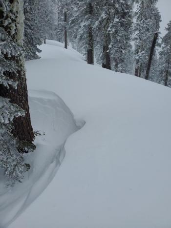
Holy cow! If you got off your skis or sleds yesterday, you would have found yourself sunk in thigh deep snow. Those that did were either out of gas or stuck. Everyone returning to Bunny Flat was caked in white. If you broke trail, you have my deepest respect.
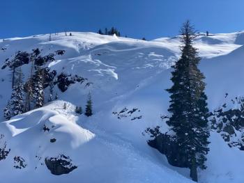
Aside from a couple of small point releases, there was no obvious signs of avalanches. There was a report of a possible slide in the steep chutes on Gray Butte, though from my vantage I could not see it. It may have become filled in during the storm.
Very little wind effect was seen in the lower regions of the Old Ski Bowl. There is ample amount of light snow available for transport.
The weak layer existing from last Saturday's storm and Sunday's warming event has not turned out to be a problem so far. The configuration seems to exist everywhere, but lower elevations reveal a stronger crust and better bonded underlying layer. I'd still be leery of this at high elevations where temperatures have remained colder.
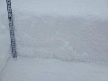
A skier triggered a 18" storm slab avalanche on a very steep slope out at Cliff Lake.
There is 97 inches of snow at 7,600 ft on Mount Shasta. In the last three days, we have received close to 30 inches of new snow. Over the last 24 hours, mean temperatures have been 18 ºF. Winds have been mostly light switching from the southwest to the east.
Weather and Current Conditions
Weather Summary
The blob of low pressure has passed through. Your annoying relative is coming to visit - the high pressure ridge. Be nice. It won't stay for long. It'll keep us dry until Sunday when up to half an inch of precipitable water is expected.
Winds will become northerly. Temperatures are on the rise. Expect mostly sunny conditions over the next few days.
24 Hour Weather Station Data @ 5:00 AM
| Weather Station | Temp (°F) | Wind (mi/hr) | Snow (in) | Comments | ||||||||
|---|---|---|---|---|---|---|---|---|---|---|---|---|
| Cur | Min | Max | Avg | Avg | Max Gust | Dir | Depth | New | Water Equivalent | Settlement | ||
| Mt. Shasta City (3540 ft) | 28 | 27 | 38 | 31.5 | 0 | N | ||||||
| Sand Flat (6750 ft) | 9 | 8 | 32 | 20 | Snow sensor down | |||||||
| Ski Bowl (7600 ft) | 12 | 11 | 30 | 17.5 | 96.6 | 0 | 0.15 | 0.8 | ||||
| Gray Butte (8000 ft) | 15.5 | 13.5 | 30 | 18 | 4 | 25 | E | |||||
| Castle Lake (5870 ft) | 20 | 20 | 37.5 | 25.5 | 15 | 0 | 0 | |||||
| Mount Eddy (6509 ft) | 18.5 | 16 | 25.5 | 20.5 | 1 | 5 | ESE | 11.6 | 0 | 66.4 | ||
| Ash Creek Bowl (7250 ft) | 15 | 14 | 24.5 | 18 | 79.1 | 0 | 3.4 | |||||
| Ash Creek Ridge (7895 ft) | 12.5 | 12.5 | 26.5 | 16.5 | 1 | 8 | wind sensor rimed |
Two Day Mountain Weather Forecast
Produced in partnership with the Medford NWS
| For 7000 ft to 9000 ft | |||
|---|---|---|---|
|
Thursday (4 a.m. to 10 p.m.) |
Thursday Night (10 p.m. to 4 a.m.) |
Friday (4 a.m. to 10 p.m.) |
|
| Weather | Mostly sunny. | Mostly clear. | Sunny. |
| Temperature (°F) | 33 | 20 | 38 |
| Wind (mi/hr) | North 5-10 | North 5-10 | North 0-5 |
| Precipitation SWE / Snowfall (in) | 0.00 / 0 | 0.00 / 0 | 0.00 / 0 |
| For 9000 ft to 11000 ft | |||
| Thursday | Thursday Night | Friday | |
| Weather | Mostly sunny and cold. | Mostly clear. Blustery. | Sunny. |
| Temperature (°F) | 14 | 14 | 26 |
| Wind (mi/hr) | Northeast 15-20 | Northeast 20-25 | Northeast 10-15 |
| Precipitation SWE / Snowfall (in) | 0.00 / 0 | 0.00 / 0 | 0.00 / 0 |
Season Precipitation for Mount Shasta City
| Period | Measured (in) | Normal (in) | Percent of Normal (%) |
|---|---|---|---|
| From Oct 1, 2025 (the wet season) | 15.44 | 31.92 | 48 |
| Month to Date (since Jun 1, 2026) | 1.86 | 2.42 | 77 |
| Year to Date (since Jan 1, 2026) | 11.86 | 16.71 | 71 |

