

You are here
Avalanche Forecast for 2021-03-13 06:20
- EXPIRED ON March 14, 2021 @ 7:20 amPublished on March 13, 2021 @ 6:20 am
- Issued by Nick Meyers - Shasta-Trinity National Forest
Bottom Line
We are several days after a storm, the winds have died off and many users are into the stepping out mindset. It's the classic low likelihood, high consequence situation. Storm instabilities have past, but large, thick and hollow wind slabs can be found out there and while triggering one is becoming less likely, the sheer size of a potential slab could be large and in charge. The avalanche danger is low below treeline and moderate near and above.


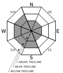
Avalanche Problem 1: Wind Slab
-
Character ?

-
Aspect/Elevation ?
-
Likelihood ?CertainVery LikelyLikelyPossible
 Unlikely
 -
Size ?HistoricVery LargeLargeSmall

Expect to find existing wind slabs on SE-S-SW-W-NW facing slopes loaded by NE winds. Slabs are several feet thick and hollow. Some easy pit test failures under the wind crust and cracking was observed on wind-loaded test slopes yesterday, but no wind slab avalanches were reported. Pay attention to pillows of wind drifted snow, ripples on the snow surface or other wind textures. These can help identify where slabs exist. Triggering a wind slab is becoming less likely, but of high consequence due to size. Additional wind loading today should be minimal.
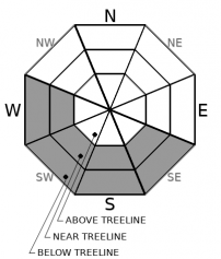
Avalanche Problem 2: Loose Wet
-
Character ?

-
Aspect/Elevation ?
-
Likelihood ?CertainVery LikelyLikelyPossible
Unlikely
-
Size ?HistoricVery LargeLargeSmall
Keep watch for loose roller balls and pinwheels forming on those south and east aspects greater than 35 degrees, below and near treeline. Low elevation slopes will experience the most warming. Wet loose avalanches can become large enough to cause problems for people in terrain with long, steep slopes. On aspects where the snow is colder, sluffs of unconsolidated dryer snow is possible. Terrain traps such as cliffs, rocks and trees exacerbate consequences. If you see signs of wet snow forming, it's a good time to look for colder snow on more shaded aspects, or move to lower angle terrain.
Recent Observations
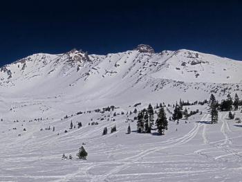
- A beautiful, full blue sky day yesterday all around the area. Snow depth on the mountain near treeline is 89 inches, still settling inches by the day. Mean temperature over the past 24 hours is 30° F, with a low of 19.5° and a high of 38.5° at treeline. Over on the west side, the snow depth is 76 inches on average. The west side has observed generally less storm snow than the mountain during this past storm. Mean temperature is 35° with a low of 25° and a high of 49°.
- We've had helter-skelter wind over the past several days. The same day we had howling wind on Mt. Shasta, skiers reported virtually no wind in the Gumboot Basin area. Overall, when and where it has been windy, the predominant direction has been east/northeast, loading those south and west aspects.
- Deep, hollow wind drifts over 2 feet thick have been observed on the mountain near and above treeline. A several inch, firm wind crust caps off soft, fist hard snow below.
- Loose roller balls have been active on those south and east facing slopes, even in the late AM hours.
- Various crusts will be found, along with some lingering powder. Snow conditions are becoming variable. Cold snow never lasts very long around here these days.
- No recent avalanches reported withing the past 24 hours.
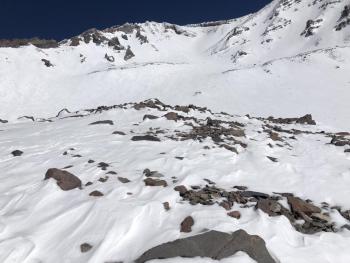
- Numerous rocks lurk beneath the snow surface. Recreational users have reported ski and snowmobile damage.
- Climbing the mountain is arduous at this time due to deep, unconsolidated snow and very deep wind drifts.
- Yesterday's observation with photos here.
- A group of Carter Meadows skiers reported a few point releases and rollerballs. A sugary layer of snow between the new snow and old crust was observed and would produce easy hand pit failures, but didn't manifest in avalanche behavior. They skied slopes up to 35 degrees.

Weather and Current Conditions
Weather Summary
Another beautiful day of weather expected. Afternoon highs will be above normal. Wind will be light for most areas, though still blustery on the upper mountain. Wear that sunscreen! For the near future, a winter weather advisory is up from the National Weather Service from Sunday afternoon through Monday morning above 4,000 feet. Snow accumulations of 3 to 6 inches is likely with locally up to 12 inches in areas. Souths wind could gust as high as 35 mi/hr.
24 Hour Weather Station Data @ 5:00 AM
| Weather Station | Temp (°F) | Wind (mi/hr) | Snow (in) | Comments | ||||||||
|---|---|---|---|---|---|---|---|---|---|---|---|---|
| Cur | Min | Max | Avg | Avg | Max Gust | Dir | Depth | New | Water Equivalent | Settlement | ||
| Mt. Shasta City (3540 ft) | 27 | 26 | 54 | 39 | 2 | N | ||||||
| Sand Flat (6750 ft) | 18 | 11 | 37 | 25 | Snow sensor down | |||||||
| Ski Bowl (7600 ft) | 27 | 19.5 | 38.5 | 30 | 89.2 | 0 | 0 | 2.2 | ||||
| Gray Butte (8000 ft) | 30.5 | 22.5 | 36.5 | 30 | 4 | 31 | SE | |||||
| Castle Lake (5870 ft) | 31.5 | 25 | 49 | 35 | 76.6 | 0 | 1.5 | |||||
| Mount Eddy (6509 ft) | 23.5 | 23.5 | 37.5 | 31 | 2 | 5 | WSW | 11.6 | 0 | 0 | ||
| Ash Creek Bowl (7250 ft) | 24 | 15 | 24 | 19 | 78.2 | 0 | 0.9 | |||||
| Ash Creek Ridge (7895 ft) | 25 | 15 | 33 | 25 | 5 | 17 | WNW | wind sensor rimed |
Two Day Mountain Weather Forecast
Produced in partnership with the Medford NWS
| For 7000 ft to 9000 ft | |||
|---|---|---|---|
|
Saturday (4 a.m. to 10 p.m.) |
Saturday Night (10 p.m. to 4 a.m.) |
Sunday (4 a.m. to 10 p.m.) |
|
| Weather | Sunny | Increasing clouds | Snow, mainly after 10am. Temperatures falling, windy. Snow level near 4,100 feet and dropping. |
| Temperature (°F) | 42 | 26 | 30 |
| Wind (mi/hr) | West 0-5 | South 0-5 | South 15-20 |
| Precipitation SWE / Snowfall (in) | 0.00 / 0 | 0.00 / 0 | 0.07 / 2-3 |
| For 9000 ft to 11000 ft | |||
| Saturday | Saturday Night | Sunday | |
| Weather | Sunny, blustery | Increasing clouds and wind | Snow, mainly in the afternoon. Windy. |
| Temperature (°F) | 28 | 25 | 25 |
| Wind (mi/hr) | North 5-10 | West 5-10 | Southwest 35-45 |
| Precipitation SWE / Snowfall (in) | 0.00 / 0 | 0.00 / 0 | 0.07 / 0 |
Season Precipitation for Mount Shasta City
| Period | Measured (in) | Normal (in) | Percent of Normal (%) |
|---|---|---|---|
| From Oct 1, 2025 (the wet season) | 15.44 | 32.37 | 48 |
| Month to Date (since Jun 1, 2026) | 1.86 | 2.87 | 65 |
| Year to Date (since Jan 1, 2026) | 11.86 | 17.16 | 69 |

