

You are here
Avalanche Forecast for 2021-03-14 06:30
- EXPIRED ON March 15, 2021 @ 6:30 amPublished on March 14, 2021 @ 6:30 am
- Issued by Ryan Sorenson - Mount Shasta Avalanche Center
Bottom Line
Winter weather will return as a cold storm impacts the area this afternoon. Fresh wind slabs will form on leeward terrain later today through tomorrow morning as new snow mixes with strong south/southwest winds. New snow totals of 6 to 12 inches are forecast with low snow levels. Recent hot temperatures followed by colder temperatures today have decreased the likelihood of triggering any large existing avalanches. Fresh wind slabs will be most sensitive to trigger late tonight and tomorrow morning.


Avalanche Problem 1: Wind Slab
-
Character ?

-
Aspect/Elevation ?
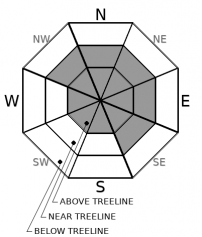
-
Likelihood ?CertainVery LikelyLikelyPossible
 Unlikely
 -
Size ?HistoricVery LargeLargeSmall

The majority of the daylight hours today will host low avalanche danger and strong wind. A cold storm this afternoon will bring south/southwesterly winds and a few inches of fresh snow. Heavy snowfall and stronger winds are expected after 4 p.m. Total snow accumulation of 6 to 12 inches is likely by tomorrow morning. Warm temperatures yesterday followed by colder temperatures today have decreased the likelihood of triggering any existing wind slabs. New wind slabs will form over various wind-packed and melt-freeze crusts that could provide an ideal bed surface.
Pay attention to the wind direction and watch for pillows of wind drifted snow, ripples on the snow surface, or other wind textures. These can help identify where slabs exist. Anticipate rising concern of fresh wind slabs as this storm materializes. Late tonight and tomorrow, wind slabs will be most sensitive to trigger.
Recent Observations
- Yesterday was another beautiful sunny day. With the sun high in the sky, Mount Shasta saw temperatures quickly climbed into the mid-40s ℉. The previously formed wind crusts became moist and soft, but it was still possible to find protected colder, larger-grained, fist-hard snow below. This will likely be capped over by the refreeze last night.
- Rollerballs forming on southerly facing slopes, settlement cones, and dripping snow from trees were observed yesterday—all signs of warming and consolidating snowpack.
- The snow depth on the mountain near treeline is 86 inches and has settled 3.1 inches over the past 24 hours. The mean temperature was 35° F, with a low of 27° and a high of 47° F.
- Over on the west side, the snow depth is 72 inches on average. The west side has observed generally less storm snow than the mountain during this week's storm. The average temperature is 41.5° with a low of 30.5° and a high of 57°F. Reports indicate colder snow still lingering on northerly aspects. The various crusts, on other aspects, became soft and moist during the heat of the day.
- No avalanches have been observed or reported in the past two days. Wind slabs were stubborn and unreactive on test slopes yesterday.
- Snow conditions were variable. Various wind and melt-freeze crusts were found, along with some lingering powder.
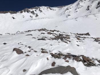
- Numerous rocks lurk beneath the snow surface. Recreational users have reported recent ski and snowmobile damage.

Weather and Current Conditions
Weather Summary
A cold front is scheduled to arrive late this afternoon, bringing snow and blizzard conditions. The snow level will start near 4,000 feet but is expected to drop as low as 1,000 feet by tomorrow morning. A winter weather advisory is in effect above 4,000 feet from 4 p.m. this afternoon to 10 a.m. Monday morning. Total snow accumulation of 6 to 8 inches is likely with locally up to 12 inches in areas. Expect strong south winds with gusts as high as 50 mi/hr.
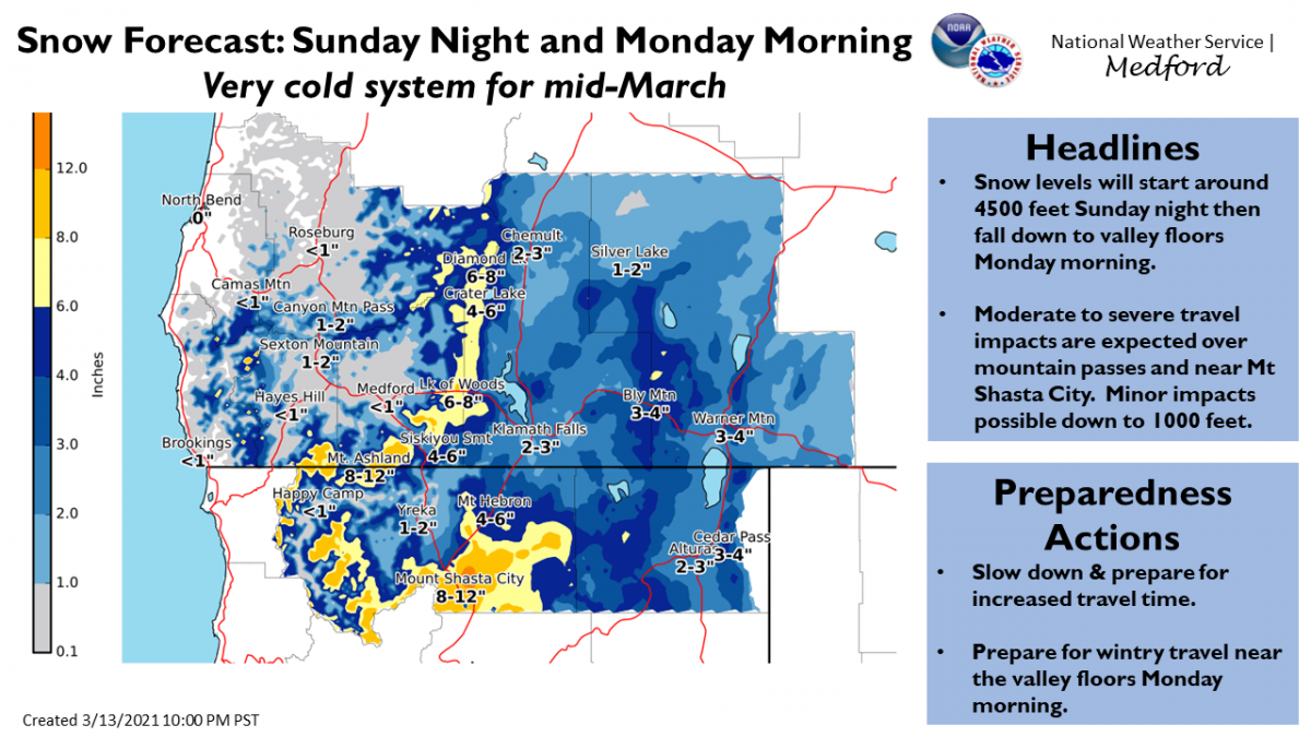
Snow forecast produced by the National Weather Service's Medford Office. Click here for the latest briefing.
24 Hour Weather Station Data @ 5:00 AM
| Weather Station | Temp (°F) | Wind (mi/hr) | Snow (in) | Comments | ||||||||
|---|---|---|---|---|---|---|---|---|---|---|---|---|
| Cur | Min | Max | Avg | Avg | Max Gust | Dir | Depth | New | Water Equivalent | Settlement | ||
| Mt. Shasta City (3540 ft) | 40 | 26 | 60 | 45.5 | 2 | N | ||||||
| Sand Flat (6750 ft) | 30 | 18 | 49 | 32 | 0 | 0 | 0 | 1 | Snow sensor down | |||
| Ski Bowl (7600 ft) | 26.5 | 26.5 | 47 | 34.5 | 86.2 | 0 | 0 | 3 | ||||
| Gray Butte (8000 ft) | 24.5 | 24.5 | 44 | 34.5 | 6 | 31 | W | |||||
| Castle Lake (5870 ft) | 29 | 29 | 57 | 41 | 72.6 | 0 | 4 | |||||
| Mount Eddy (6509 ft) | 29 | 23.5 | 45.5 | 35.5 | 3 | 6 | WSW | 11.6 | 0 | 0 | ||
| Ash Creek Bowl (7250 ft) | 27 | 23.5 | 47 | 34 | 72.3 | 0 | 2.7 | |||||
| Ash Creek Ridge (7895 ft) | 23.5 | 23.5 | 46 | 34 | 7 | 39 | SW | wind sensor rimed |
Two Day Mountain Weather Forecast
Produced in partnership with the Medford NWS
| For 7000 ft to 9000 ft | |||
|---|---|---|---|
|
Sunday (4 a.m. to 10 p.m.) |
Sunday Night (10 p.m. to 4 a.m.) |
Monday (4 a.m. to 10 p.m.) |
|
| Weather | Snow, mainly after 10 a.m. Temperatures falling, windy. Snow level near 4,100 feet and dropping. | Breezy. Snow in the evening, then snow showers after midnight. | Windy. Mostly cloudy in the morning then becoming partly cloudy. Snow showers likely before 10 am then clearing. |
| Temperature (°F) | 29 | 14 | 27 |
| Wind (mi/hr) | South 20-25 | West 15-20 | Northwest 15-20 |
| Precipitation SWE / Snowfall (in) | 0.17 / 1-3 | 0.40 / 4-8 | 0.29 / 3-4 |
| For 9000 ft to 11000 ft | |||
| Sunday | Sunday Night | Monday | |
| Weather | Windy. Mostly cloudy. Snow likely this morning, then snow this afternoon. | Breezy. Snow in the evening, then snow showers after midnight. | Windy. Mostly cloudy in the morning then becoming partly cloudy. Snow showers likely before 10 am then clearing. |
| Temperature (°F) | 27 | 8 | 20 |
| Wind (mi/hr) | Southwest 45-50 | South 30-35 | North 20-25 |
| Precipitation SWE / Snowfall (in) | 0.17 / 1-3 | 0.40 / 6-12 | 0.29 / 1-3 |
Season Precipitation for Mount Shasta City
| Period | Measured (in) | Normal (in) | Percent of Normal (%) |
|---|---|---|---|
| From Oct 1, 2025 (the wet season) | 15.44 | 32.59 | 47 |
| Month to Date (since Jun 1, 2026) | 1.86 | 3.09 | 60 |
| Year to Date (since Jan 1, 2026) | 11.86 | 17.38 | 68 |

