

You are here
Avalanche Forecast for 2021-03-15 06:45
- EXPIRED ON March 16, 2021 @ 6:45 amPublished on March 15, 2021 @ 6:45 am
- Issued by Ryan Sorenson - Mount Shasta Avalanche Center
Bottom Line
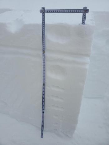
Overnight, 5-8 inches of snow fell with cold temperatures and variable winds. Medium to large-sized fresh wind slabs are likely near and above treeline. Lingering showers and productive winds today will continue to increase the size and distribution of wind slabs. Cold loose sluffs are possible on terrain steeper than 40 degrees. Storm slabs could form as well. A cautious assessment of the snowpack is necessary if traveling near or in avalanche terrain.


Avalanche Problem 1: Wind Slab
-
Character ?

-
Aspect/Elevation ?
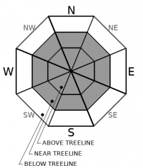
-
Likelihood ?CertainVery LikelyLikelyPossible
 Unlikely
 -
Size ?HistoricVery LargeLargeSmall

Wind slabs will top the problem list today. Up to 8 inches of snow has accumulated so far and lingering snow showers are expected to continue. This storm is cold and the majority of the fresh snow will be easily transported and shaped into wind slabs. Wind speeds and directions have been all over the place but are trending towards northeasterly this morning. Productive light to moderate northerly wind is forecast today. This will likely produce medium to large-sized wind slabs. New wind slabs will form over various wind-packed and melt-freeze crusts that could provide an ideal bed surface.
Expect wind slabs on loaded slopes to be sensitive to human/machine triggering today. Be willing to step back into safer terrain if you encounter these signs: whumphing sounds, shooting cracks, and hollow snow. It's best to give the snow another day to settle out before hard-charging the steeps.
Avalanche Problem 2: Loose Dry
-
Character ?

-
Aspect/Elevation ?
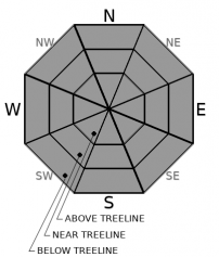
-
Likelihood ?CertainVery LikelyLikelyPossible
Unlikely
-
Size ?HistoricVery LargeLargeSmall
This storm is colder than the typical storms we see in March. Temperatures and snow levels dropped throughout the night and are expected to remain low today. Dry, unbonded snow atop various crusts may sluff off and cause loose-dry avalanches in terrain steeper than 40 degrees.
Loose snow avalanches usually start from a point and fan outward as they descend. They are less dangerous than slab avalanches but can sweep you off your feet into terrain traps or cliff areas.
Avalanche Problem 3: Storm Slab
-
Character ?

-
Aspect/Elevation ?
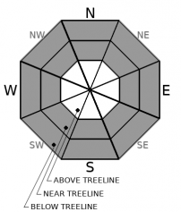
-
Likelihood ?CertainVery LikelyLikelyPossible
Unlikely
-
Size ?HistoricVery LargeLargeSmall
Cold temperatures may keep storm slabs from forming, but be prepared for them on steep slopes over 40 degrees. Storm slabs typically occur when the new snow is stronger than underlying snow that had previously fell or it does not bond well with the old snow surfaces.
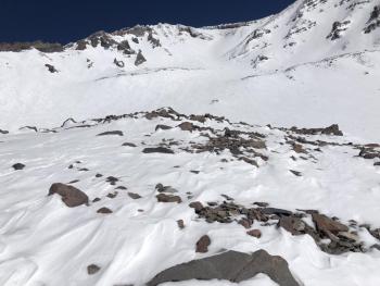
You usually find storm slabs near and below treeline where slopes are more protected from the wind. The west side of Gray Butte, down in the chutes is classic storm slab location.
Forecast Discussion
Storm slab and loose dry instabilities tend to be short-lived, especially with March's high sun angle. However, colder forecasted temperatures with this storm could allow these instabilities to linger throughout the day.
Recent Observations
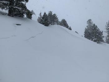
Yesterday was overcast with mixed fog and cumulonimbus storm clouds. Snow began to fall at approximately 1400 hours and continued through the night. Snow totals and temperatures from around the area last night:
- Old Ski Bowl - 5.5 inches / 24 hr Temp (Low - High): 16-44 °F
- Castle Lake - 6.6 inches / 19.5-30 °F
- Mount Eddy - 7 inches / 17.5-30 °F
- Ash Creek Butte - 8 inches / 16-28 °F
Before the current storm, the area had received a significant snowfall on March 8th - 10th. A few wind slabs were observed on March 11th. Warm, sunny days with large diurnal temperature swings and the wind had settled and transitioned the snowpack throughout the weekend. Various wind and melt-freeze crusts were dominant, along with some lingering powder in protected pockets and colder aspects.
Weather and Current Conditions
Weather Summary
The cold front that blanketed snow across the region overnight will begin to move eastward. The NWS winter storm warning will expire at 10 a.m. Continued showers are likely. These will gradually decrease this afternoon. Sunny skies will return tomorrow and prevail until Wednesday afternoon when another strong and wet cold front arrives from the Gulf of Alaska. Models show around an inch of water with this system.
24 Hour Weather Station Data @ 5:00 AM
| Weather Station | Temp (°F) | Wind (mi/hr) | Snow (in) | Comments | ||||||||
|---|---|---|---|---|---|---|---|---|---|---|---|---|
| Cur | Min | Max | Avg | Avg | Max Gust | Dir | Depth | New | Water Equivalent | Settlement | ||
| Mt. Shasta City (3540 ft) | 40 | 26 | 60 | 45.5 | 2 | N | ||||||
| Sand Flat (6750 ft) | 19 | 18 | 29 | 25 | Snow sensor down | |||||||
| Ski Bowl (7600 ft) | 15 | 15 | 29 | 21.5 | 90.5 | 5.5 | 0 | 0 | ||||
| Gray Butte (8000 ft) | 14.5 | 14.5 | 23.5 | 20 | 10 | 43 | SSW | |||||
| Castle Lake (5870 ft) | 19 | 19 | 30 | 25 | 80 | 6.6 | 0 | |||||
| Mount Eddy (6509 ft) | 16 | 16 | 30.5 | 23.5 | 2 | 6 | SSE | 81.2 | 8 | 0 | ||
| Ash Creek Bowl (7250 ft) | 15.5 | 15.5 | 26 | 21 | 80.3 | 8 | 0 | |||||
| Ash Creek Ridge (7895 ft) | 11 | 11 | 25 | 17.5 | 7 | 46 | wind sensor rimed |
Two Day Mountain Weather Forecast
Produced in partnership with the Medford NWS
| For 7000 ft to 9000 ft | |||
|---|---|---|---|
|
Monday (4 a.m. to 10 p.m.) |
Monday Night (10 p.m. to 4 a.m.) |
Tuesday (4 a.m. to 10 p.m.) |
|
| Weather | Windy. Mostly cloudy with snow showers likely this morning, then partly cloudy with a slight chance of snow showers this afternoon. | Mostly clear. Slight chance of snow showers in the evening. | Sunny. |
| Temperature (°F) | 27 | 11 | 34 |
| Wind (mi/hr) | Northwest 15-20 | North 10-15 | North 5-10 |
| Precipitation SWE / Snowfall (in) | 0.23 / 1-3 | 0.00 / 0-0.50 | 0.00 / 0-0.50 |
| For 9000 ft to 11000 ft | |||
| Monday | Monday Night | Tuesday | |
| Weather | Windy. Mostly cloudy with snow showers likely this morning, then partly cloudy with a slight chance of snow showers this afternoon. | Mostly clear. Slight chance of snow showers in the evening. | Sunny. |
| Temperature (°F) | 20 | 16 | 23 |
| Wind (mi/hr) | Northeast 20-25 | North 15-25 | Southeast 15-20 |
| Precipitation SWE / Snowfall (in) | 0.23 / 1-3 | 0.00 / 0-1 | 0.00 / 0 |
Season Precipitation for Mount Shasta City
| Period | Measured (in) | Normal (in) | Percent of Normal (%) |
|---|---|---|---|
| From Oct 1, 2025 (the wet season) | 15.92 | 32.80 | 49 |
| Month to Date (since Jul 1, 2026) | 2.34 | 3.30 | 71 |
| Year to Date (since Jan 1, 2026) | 12.34 | 17.59 | 70 |

