

You are here
Avalanche Forecast for 2021-03-16 06:00
- EXPIRED ON March 17, 2021 @ 6:00 amPublished on March 16, 2021 @ 6:00 am
- Issued by Aaron Beverly - Mount Shasta Avalanche Center
Bottom Line
Avalanche danger is considerable. Wind slabs and natural wind slab avalanches occurred yesterday. Wind slabs will continue to grow today. Human-triggered avalanches will be likely. Evaluate terrain and the snowpack carefully. Conditions could widely vary over the forecast area. Another storm will pass through late Wednesday night.


Avalanche Problem 1: Wind Slab
-
Character ?

-
Aspect/Elevation ?
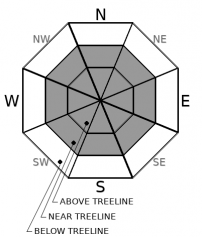
-
Likelihood ?CertainVery LikelyLikelyPossible
 Unlikely
 -
Size ?HistoricVery LargeLargeSmall

Winds were all over the map yesterday -- from calm to gale force. Wind slabs were encountered and wind slab avalanches did occur. Productive northwest winds above treeline may continue to increase the size of existing slabs. They may sit atop a weak breakable crust. On Mount Shasta they'll be smaller. In the Eddies they could be very large. Human triggered avalanches will be likely on steep leeward slopes.
Pay attention to these signs: whumphing sounds, shooting cracks, and hollow snow. If you see or experience these things, winds slabs are nearby.
Avalanche Problem 2: Storm Slab
-
Character ?

-
Aspect/Elevation ?
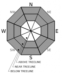
-
Likelihood ?CertainVery LikelyLikelyPossible
Unlikely
-
Size ?HistoricVery LargeLargeSmall
Column tests indicated some concern for storm slabs yesterday. Today sun and warmer temperatures could create an upside down configuration in the new snow causing the upper snow to become more cohesive. Be leary of this problem on slopes approaching 40 degrees. This type of slab will be small on Mount Shasta, but could be larger in the Eddies.
Storm Slabs form when new snow consolidates over a weaker layer or interface. The weak point can be snow that fell early in the storm or just a poor bond with the old snow surface.
Forecast Discussion
Evaluate terrain and the snowpack carefully today. Based on the sporadic weather yesterday you may find different conditions everywhere you go. It'll be best to let things settle a bit longer before stepping out onto those steep slopes.
Recent Observations
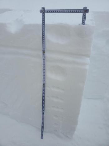
It was curious day yesterday. You had blizzard conditions in town until mid-morning, while things were calm and clearing by 8:30 a.m. at the ski park. About 5 inches of new light density snow could be found on Gray Butte and in the Old Ski Bowl with not much wind effect, though some small drifts were found where blocking and shooting cracks could be produced. Column tests indicated the potential for a storm slab problem. Winds on Gray Butte remained light throughout the last 24 hours and temperatures stayed below freezing, though aspects exposed to direct sun did soften.
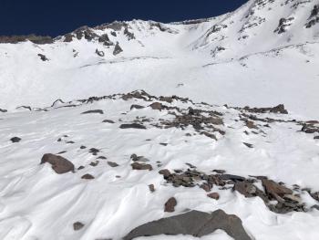
Meanwhile up Parks Creek drainage, winter was full on with strong northerly winds and up to 2 feet of fresh snow. Four foot drifts, wind slabs, and D2 natural avalanches were all encountered.
Castle Lake was hammered by east winds. Breaking cornices, big hollow wind pillows, and small natural avalanches were all encountered.
It all goes to show that conditions in one place do not necessary apply to all regions in our forecast area. See yesterday's observations for details.
Weather and Current Conditions
Weather Summary
A high pressure ridge is building to the west. Sunny weather returns. A high of 34 is expected near treeline. Northwest winds will be moderate.
The ridge will move east by Wednesday afternoon. A storm will roll in soon after bringing over an inch of water to the area.
24 Hour Weather Station Data @ 4:00 AM
| Weather Station | Temp (°F) | Wind (mi/hr) | Snow (in) | Comments | ||||||||
|---|---|---|---|---|---|---|---|---|---|---|---|---|
| Cur | Min | Max | Avg | Avg | Max Gust | Dir | Depth | New | Water Equivalent | Settlement | ||
| Mt. Shasta City (3540 ft) | 22 | 22 | 27 | N | ||||||||
| Sand Flat (6750 ft) | 10 | 10 | 27 | 19 | Snow sensor down | |||||||
| Ski Bowl (7600 ft) | 15 | 15 | 28 | 21 | 87.3 | 0 | 0.35 | 3.2 | ||||
| Gray Butte (8000 ft) | 16.5 | 14.5 | 23 | 19.5 | 8 | 55 | ESE | |||||
| Castle Lake (5870 ft) | 13.5 | 13.5 | 24 | 18.5 | 79.2 | 0 | 0.8 | |||||
| Mount Eddy (6509 ft) | 11.5 | 11.5 | 22 | 16.5 | 3 | 8 | SSE | 82.3 | 1.1 | 0 | ||
| Ash Creek Bowl (7250 ft) | 19.5 | 13.5 | 22.5 | 16.5 | 84.1 | 3.3 | 0 | |||||
| Ash Creek Ridge (7895 ft) | 10 | 8.5 | 19.5 | 12.5 | wind sensor rimed |
Two Day Mountain Weather Forecast
Produced in partnership with the Medford NWS
| For 7000 ft to 9000 ft | |||
|---|---|---|---|
|
Tuesday (4 a.m. to 10 p.m.) |
Tuesday Night (10 p.m. to 4 a.m.) |
Wednesday (4 a.m. to 10 p.m.) |
|
| Weather | Sunny | Mostly clear. | Partly sunny. |
| Temperature (°F) | 34 | 19 | 35 |
| Wind (mi/hr) | Northeast 0-5 | South 0-5 | South 5-10 |
| Precipitation SWE / Snowfall (in) | 0.00 / 0 | 0.00 / 0 | 0.00 / 0 |
| For 9000 ft to 11000 ft | |||
| Tuesday | Tuesday Night | Wednesday | |
| Weather | Sunny. Moderate winds. Low wind chills. | Mostly clear. Light winds. | Mostly sunny. Moderate winds. |
| Temperature (°F) | 27 | 27 | 27 |
| Wind (mi/hr) | Northeast 20-25 | Northwest 15-20 | Southwest 20-25 |
| Precipitation SWE / Snowfall (in) | 0.00 / 0 | 0.00 / 0 | 0.00 / 0 |
Season Precipitation for Mount Shasta City
| Period | Measured (in) | Normal (in) | Percent of Normal (%) |
|---|---|---|---|
| From Oct 1, 2025 (the wet season) | 16.41 | 33.00 | 50 |
| Month to Date (since Jun 1, 2026) | 2.83 | 3.50 | 81 |
| Year to Date (since Jan 1, 2026) | 12.83 | 17.79 | 72 |

