

You are here
Avalanche Forecast for 2021-03-17 06:30
- EXPIRED ON March 18, 2021 @ 6:30 amPublished on March 17, 2021 @ 6:30 am
- Issued by Aaron Beverly - Mount Shasta Avalanche Center
Bottom Line
Overall, avalanche danger is low. A strong melt-freeze cycle has settled and crusted the snowpack. But continue to pay attention to conditions around you. Wind slabs may still linger in isolated or extreme terrain. Expect increasing clouds as a warm front begins to enter the area. A storm will follow early tomorrow morning bringing up to 12 inches of snow at high elevations.


Avalanche Problem 1: Wind Slab
-
Character ?

-
Aspect/Elevation ?
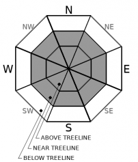
-
Likelihood ?CertainVery LikelyLikelyPossible
 Unlikely
 -
Size ?HistoricVery LargeLargeSmall

Overall, avalanche danger is low. Wind slabs did not continue to build yesterday in most places as the winds turned out to be mostly calm. Nonetheless, wind slabs may still linger in isolated areas or in extreme terrain. A crust will have covered up much of the remaining low density snow reducing its availability for transport. But the forecast area is large and conditions can vary from place to place, aspect to aspect, and elevation to elevation. Winds were transporting snow yesterday morning near the Red Banks on Mount Shasta.
If you do see blowing snow or are finding wind drifts with blocking snow, be wary of wind slabs on steep, leeward slopes nearby.
Forecast Discussion
There was enough sun and warmth yesterday to create a concern for wet loose slides. This concern has diminished with a strong melt-freeze cycle. There will also be less sun today. Nonetheless, if you find yourself in ankle deep wet snow, you may want to avoid steep slopes nearby.
Recent Observations
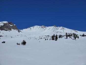
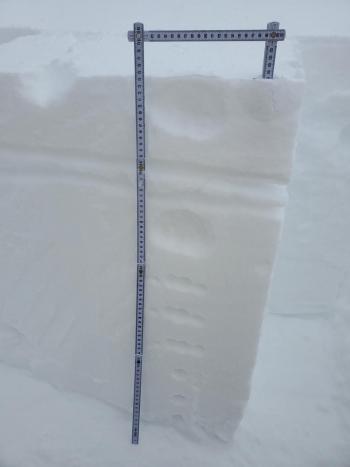
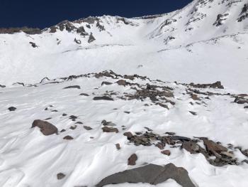
On Mount Shasta, the snowpack changed quickly yesterday in the warmer temperatures and sun. By the end of the day, melt-freeze crusts were forming. Winds were calm below 10,000 ft. High above treeline, northwest winds were transporting snow. As you transitioned to above treeline elevations, there were plenty of sastrugis and wind hardened snow. The higher you got, the less low density snow was available. The best snow for sliding was near and below treeline. With temperatures in the teens last night, the snowpack exposed to the sun will be locked up by crusts.
Though things were much deeper out in the Eddies, winds were dead calm and the sun was baking the upper pack. Wet loose slides seemed possible, but by the end of the day things were hardening.
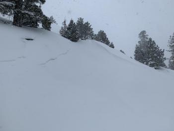
The weak crust and underlying low density snow where easy failures were seen on Monday, was widespread. The new crust that was forming yesterday afternoon, also with underlying low density snow, could present another weak area in the snowpack when additional weight is added - something to keep an eye on after Thursday's storm. It could also provide a smooth bed surface for new snow to slide on.
About an inch of surface hoar was observed at Bunny Flat. It got destroyed in the sun, but it may linger on shady and north facing aspects. Keep an eye out for it.
Weather and Current Conditions
Weather Summary
The high pressure ridge that brought us a beautiful, sunny day yesterday is moving east. A warm front will follow. With it will come increasing clouds and southerly winds. There is not much happening today, but early tomorrow morning a warm, wet storm will bring very high winds and up to 12 inches of snow at high elevations. Snow levels will be around 4,300 ft.
24 Hour Weather Station Data @ 4:00 AM
| Weather Station | Temp (°F) | Wind (mi/hr) | Snow (in) | Comments | ||||||||
|---|---|---|---|---|---|---|---|---|---|---|---|---|
| Cur | Min | Max | Avg | Avg | Max Gust | Dir | Depth | New | Water Equivalent | Settlement | ||
| Mt. Shasta City (3540 ft) | 27 | 22 | 43 | 33 | 2 | N | ||||||
| Sand Flat (6750 ft) | 24 | 8 | 33 | 24 | Snow sensor down | |||||||
| Ski Bowl (7600 ft) | 19 | 13.5 | 32 | 23 | 86.7 | 0 | 0 | 0.6 | ||||
| Gray Butte (8000 ft) | 19 | 15 | 27 | 20.5 | 5 | 18 | SSW | |||||
| Castle Lake (5870 ft) | 23.5 | 12.5 | 37.5 | 26.5 | 74.7 | 0 | 3.9 | |||||
| Mount Eddy (6509 ft) | 20.5 | 9.5 | 30 | 22 | 2 | 5 | WSW | 79.3 | 0 | 2.8 | ||
| Ash Creek Bowl (7250 ft) | 18 | 8.5 | 31.5 | 20.5 | 78.7 | 0 | 3.3 | |||||
| Ash Creek Ridge (7895 ft) | 17.5 | 7.5 | 30 | 20.5 | 2 | 11 | SSE | wind sensor has been rimed |
Two Day Mountain Weather Forecast
Produced in partnership with the Medford NWS
| For 7000 ft to 9000 ft | |||
|---|---|---|---|
|
Wednesday (4 a.m. to 10 p.m.) |
Wednesday Night (10 p.m. to 4 a.m.) |
Thursday (4 a.m. to 10 p.m.) |
|
| Weather | Partly sunny. | A 40 percent chance of snow after 11 p.m. Mostly cloudy. | Snow. Patchy blowing snow. Windy. Chance of precipitation is 90%. |
| Temperature (°F) | 34 | 26 | 31 |
| Wind (mi/hr) | South 5-10 | South 15-20 | South 20-25 |
| Precipitation SWE / Snowfall (in) | 0.00 / 0 | 0.00 / 0 | 1.10 / 6-10 |
| For 9000 ft to 11000 ft | |||
| Wednesday | Wednesday Night | Thursday | |
| Weather | Mostly sunny. | A 40 percent chance of snow after 11 p.m. Mostly cloudy. Windy. Low wind chills. | Snow. Widespread blowing snow. Very windy. Low wind chills. Chance of precipitation is 100%. |
| Temperature (°F) | 27 | 19 | 20 |
| Wind (mi/hr) | Southwest 15-20 | South 35-45 | South 45-55 |
| Precipitation SWE / Snowfall (in) | 0.00 / 0 | 0.00 / 0 | 1.10 / 8-12 |
Season Precipitation for Mount Shasta City
| Period | Measured (in) | Normal (in) | Percent of Normal (%) |
|---|---|---|---|
| From Oct 1, 2025 (the wet season) | 16.41 | 33.20 | 49 |
| Month to Date (since Jun 1, 2026) | 2.83 | 3.70 | 76 |
| Year to Date (since Jan 1, 2026) | 12.83 | 17.99 | 71 |

