

You are here
Avalanche Forecast for 2021-03-22 06:15
- EXPIRED ON March 23, 2021 @ 6:15 amPublished on March 22, 2021 @ 6:15 am
- Issued by Ryan Sorenson - Mount Shasta Avalanche Center
Bottom Line
Light snow showers are possible above 4,700 feet today. Triggering an avalanche is unlikely, but isolated wind slabs are not impossible. Firm icy slopes pose the hazard of a dangerous long sliding fall on steep exposures.


Avalanche Problem 1: Normal Caution
-
Character ?

-
Aspect/Elevation ?
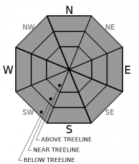
-
Likelihood ?CertainVery LikelyLikelyPossible
 Unlikely
 -
Size ?HistoricVery LargeLargeSmall

Cold temperatures and strong winds will keep the snowpack locked up. The current snowpack hosts little available snow for transport, but isolated pockets are possible. If we receive more snow than forecasted, fresh wind slabs will form. However, this is unlikely; nevertheless, keep an eye on where the wind is blowing snow and use caution traveling across recently loaded slopes.
There is a high degree of variability throughout the forecast region. Challenging travel with breakable crusts and firm icy slopes is possible. Make sure to develop a plan before you head out with your group and practice good communication throughout the day. Be prepared to change plans to a more conservative option if instabilities or challenging conditions are encountered.
Forecast Discussion
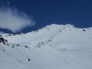
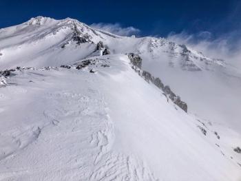
Today is not an ideal day to attempt a summit climb of Mount Shasta. Cold temperatures and strong wind will keep snow surfaces firm. Scoured icy surfaces with patches of barely covered rocks present the hazard of a dangerous long sliding fall with many obstacles to hit. Building clouds and low visibility is likely all day. Do not climb into a whiteout, carry navigation tools, and be prepared for winter-like conditions.
Recent Observations
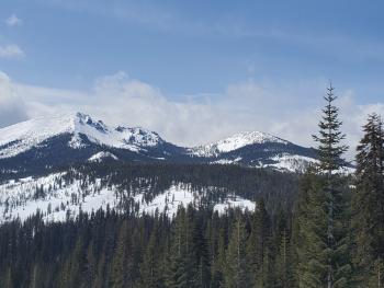
The snowpack was in a state of transition yesterday. While the spring sun was busy warming south and easterly faces, north and westerly slopes held on to their cold snow as long as possible.
- South and east-facing slopes and gullies hosted smooth surface textures but were inconsistent - crusts lingered.
- Rollerballs and pinwheels were forming on solar aspects.
- Snow surfaces were melting and becoming moist. Widespread melt-freeze crusts likely formed.
- More snow exists in gullies, depressions, and on leeward slopes.
- The wind has scoured out large patches of rocks and old icy snow surfaces across the West Face and Casaval Ridge.
- The moraine tops and the west side of Sargents Ridge were also scoured in Avalanche Gulch.
- No major signs of unstable snow, significant cracking, or instability have been encountered or reported.
Weather and Current Conditions
Weather Summary
A cold front currently moving across southern Oregon may spill a little moisture into the Mount Shasta area. Expect mostly cloudy skies and occasional light snow showers. Northwest winds will be strong for exposed upper elevations on the mountain. Lower elevations will have light westerly winds. Little accumulation of snow is expected, but we may see flakes as low as 4,700 feet. Winds will pick up as the storm exits to the east tonight.
Similar to this cold front, another showery storm will miss us to the north on Wednesday night. Next weekend looks sunny and warm.
24 Hour Weather Station Data @ 6:00 AM
| Weather Station | Temp (°F) | Wind (mi/hr) | Snow (in) | Comments | ||||||||
|---|---|---|---|---|---|---|---|---|---|---|---|---|
| Cur | Min | Max | Avg | Avg | Max Gust | Dir | Depth | New | Water Equivalent | Settlement | ||
| Mt. Shasta City (3540 ft) | 31 | 31 | 48 | 39 | 2 | N | ||||||
| Sand Flat (6750 ft) | 29 | 13 | 40 | 29 | 0 | 0 | 0 | 0 | Snow sensor down | |||
| Ski Bowl (7600 ft) | 27.5 | 18.5 | 38 | 30.5 | 85.6 | 0 | 0.19 | 1.2 | ||||
| Gray Butte (8000 ft) | 26.5 | 17 | 32 | 27.5 | 7 | 43 | WNW | |||||
| Castle Lake (5870 ft) | 27 | 21.5 | 44.5 | 32.5 | 78.9 | 2.4 | 0 | |||||
| Mount Eddy (6509 ft) | 24.5 | 21.5 | 36.5 | 30 | 2 | 6 | SE | 77.3 | 0 | 0.9 | ||
| Ash Creek Bowl (7250 ft) | 24 | 15 | 35.5 | 26.5 | 75.3 | 0 | 1.6 | |||||
| Ash Creek Ridge (7895 ft) | 21 | 12 | 25.5 | 20.5 | 7 | 25 | wind sensor rimed |
Two Day Mountain Weather Forecast
Produced in partnership with the Medford NWS
| For 7000 ft to 9000 ft | |||
|---|---|---|---|
|
Monday (4 a.m. to 10 p.m.) |
Monday Night (10 p.m. to 4 a.m.) |
Tuesday (4 a.m. to 10 p.m.) |
|
| Weather | Mostly cloudy. Chance of snow showers. Snow level near 4,700 feet. | Mostly cloudy with a chance of snow showers in the evening, then partly cloudy with a slight chance of snow showers after midnight. | Sunny. |
| Temperature (°F) | 35 | 19 | 38 |
| Wind (mi/hr) | West 5-10 | Northwest 10-15 | North 10-15 |
| Precipitation SWE / Snowfall (in) | 0.01 / 0-1 | 0.00 / 0-0.50 | 0.00 / 0 |
| For 9000 ft to 11000 ft | |||
| Monday | Monday Night | Tuesday | |
| Weather | Mostly cloudy. Chance of snow showers. | Mostly cloudy with a chance of snow showers in the evening, then partly cloudy with a slight chance of snow showers after midnight. | Sunny. |
| Temperature (°F) | 17 | 13 | 22 |
| Wind (mi/hr) | Northwest 30-35 | North 35-40 | Northeast 50-55 |
| Precipitation SWE / Snowfall (in) | 0.01 / 0-1 | 0.00 / 0-0.50 | 0.00 / 0 |
Season Precipitation for Mount Shasta City
| Period | Measured (in) | Normal (in) | Percent of Normal (%) |
|---|---|---|---|
| From Oct 1, 2025 (the wet season) | 17.13 | 34.04 | 50 |
| Month to Date (since Jun 1, 2026) | 3.55 | 4.54 | 78 |
| Year to Date (since Jan 1, 2026) | 13.55 | 18.83 | 72 |

