Submitted by nmeyers on Thu, 02/02/2023 - 6:13am
Recent Observations:
A variety of recent observations have been posted from Green Butte, Gray Butte, Casaval Ridge and Old Ski Bowl. Precipitation, red flags of avalanche danger and recent avalanches have all been absent for the good part of two weeks. The snowpack and trees have been ravaged by wind. Variable snow surfaces are littered with forest debris near and below treeline. Yesterday, sunny slopes became sun softened. Shaded northerly slopes held soft snow. Over the past 3 days near treeline at 8,000 feet, temperatures have ranged from 18° to 42° F. Wind has blow predominantly out of the west-northwest, averaging 10 mi/hr with gusts to 55 mi/hr. New snow this week will fall onto various slick and firm bed surfaces.
Mountain Weather:
For the West Coast, a cold front entering the region on Friday followed by a separate system late Saturday will usher in rounds of unsettled weather. The main impacts are wind and heavy snow, which could add up to a foot over high peaks. The first front will arrive late tonight into tomorrow. A few high clouds will start to creep in this morning. Ahead of the front, expect gusty south wind. Precipitation will begin most likely on Friday morning. Southern Siskiyou County will see enhanced precipitation due to south flow and up slope wind. Snow level will generally be around 3,500 to 4,000 feet. The highest snowfall amounts will be locally, with 3 to 5 inches expected over a 24-hour period. Precipitation will taper off Friday. The next system will arrive late Saturday into Sunday and looks to be more robust. 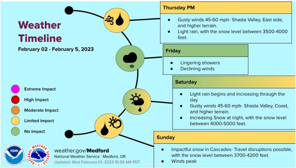
Today 7-8 Weather :
Mostly sunny, increasing clouds and windy. Snow level 4,200 feet
Today 7-8 Wind Direction:
S
Today 8-9 Weather:
Increasing clouds and windy
Today 8-9 Wind Direction:
S
Tomorrow 7-8 Weather:
Snow likely, heavy at times, windy. Snow level 3,900 feet
Tomorrow 7-8 Wind Direction:
S
Tomorrow 8-9 Weather:
Snow likely, mainly before 10am, heavy at times, windy
Tomorrow 8-9 Wind Direction:
S
Tonight 7-8 Weather:
Very windy, chance of snow in the evening, snow likely after midnight. Snow level 4,100 feet
Tonight 7-8 Wind Direction:
S
Tonight 8-9 Weather:
Mostly cloudy, snow likely after 4am, heavy at times, windy
Tonight 8-9 Wind Direction:
S
26
21
42
30
99
0
0
19
19
23
21.5
145
0
0
Grey Butte Temp Max:
40.5
Grey Butte Wind Max:
15.5
Grey Butte Wind Gust Max:
42.93
Castle Lake Temp Cur:
29.5
Castle Lake Temp Min:
29.5
Mount Eddy Wind Gust Max:
5.07
Mount Eddy Snow Depth:
100.8
Ash Creek Bowl Temp Cur:
29.5
Ash Creek Bowl Temp Min:
27.5
Ash Creek Bowl Temp Max:
38.5
Ash Creek Bowl Temp Avg:
33
Ash Creek Bowl Snow New:
0
Ash Creek Ridge Temp Cur:
23
Ash Creek Ridge Temp Min:
23
Ash Creek Ridge Temp Max:
41.5
Ash Creek Ridge Temp Avg:
31.5
Ash Creek Ridge Wind Cur:
22.5
Ash Creek Ridge Wind Max:
27
Ash Creek Ridge Wind Gust Max:
40.22
Ash Creek Ridge Wind Avg:
E
Mt. Shasta City Temp Cur:
40
Mt. Shasta City Temp Min:
22
Mt. Shasta City Temp Max:
53
Mt. Shasta City Temp Avg:
36.5
Mt. Shasta City Wind Cur:
0
Mt. Shasta City Wind Min:
0
Mt. Shasta City Wind Max:
0
Mt. Shasta City Wind Avg:
0
Mt. Shasta City Wind Avg:
N
Ash Creek Ridge Wind Min:
1.5
Ash Creek Ridge Wind Avg:
10.5
Sand Flat Snow Settlement:
1
Ski Bowl Snow Settlement:
1
Mount Eddy Snow Settlement:
0
Ash Creek Bowl Snow Settlement:
0
Measured Precipitation Oct:
25.88
Normal Precipitation Oct:
18.72
Percent Precipitation Oct:
138
Measured Precipitation MTD:
0
Normal Precipitation MTD:
0.19
Percent Precipitation MTD:
0
Measured Precipitation YTD:
16.75
Normal Precipitation YTD:
6.48
Percent Precipitation YTD:
258
Tomorrow Wind Max 7-9:
30
Tomorrow Wind Min 7-9:
20
Tonight Wind Max 9-11:
65
Tomorrow Wind Max 9-11:
60
Tonight Wind Min 9-11:
55
Tomorrow Wind Min 9-11:
50
Tonight Snow Max 7-9:
3.00
Tomorrow Snow Max 7-9:
6.00
Tonight Snow Min 7-9:
1.00
Tomorrow Snow Min 7-9:
3.00
Today Snow Max 9-11:
0.00
Tonight Snow Max 9-11:
4.00
Tomorrow Snow Max 9-11:
8.00
Today Snow Min 9-11:
0.00
Tonight Snow Min 9-11:
2.00
Tomorrow Snow Min 9-11:
4.00
Weather Station Discussion:
The table below summarizes data reported from all of our weather stations over the last 24 hours.
Seasonal Stats Discussion:
The wet season is October 1 through May 1. The table below summarizes recorded vs. normal precipitation amounts for the City of Mount Shasta.
Overall Danger Rating:
Low


