-
EXPIRED ON February 13, 2020 @ 5:00 amPublished on February 12, 2020 @ 5:00 am
-
Issued by
Aaron Beverly - Mount Shasta Avalanche Center
Avalanche danger is LOW. Sunny and clear weather will prevail. Firm conditions exist above treeline. Bring an ice axe, crampons, and a helmet if ascending high into the alpine. Beware of falling ice along climbing routes.
Generally safe avalanche conditions. Watch for unstable snow on isolated terrain features.
Generally safe avalanche conditions. Watch for unstable snow on isolated terrain features.
Generally safe avalanche conditions. Watch for unstable snow on isolated terrain features.
Forecast Hotline: (530) 926-9613
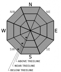
Below Treeline is the lowest of three elevation bands used in the advisories. It extends from valley floors or snowline to Near Treeline. Open areas and sparse trees are possible. Snowfall tends to be less than the other elevation bands. Tree cover shelters the snow from wind effects.
×Near Treeline is the middle of the three elevation bands used in the advisories. It is a transition zone between dense forests and treeless alpine areas. It is the narrowest of the three elevation bands, extending only a few hundred feet above and below the treeline. It varies locally, and is not a constant elevation or width.
×Above Treeline is the highest of the three elevation bands used in the advisories. It includes alpine areas where the most snow falls and the winds are the strongest. It is not an exact elevation, but a characteristic of the terrain, beginning as the treeline transitions into open slopes extending to ridges and the tops of the highest peaks.
×North American Avalanche Danger Scale
Avalanche danger is determined by the likelihood, size and distribution of avalanches.
Watch for signs of unstable snow such as recent avalanches, cracking in the snow, and audible collapsing. Avoid traveling on or under similar slopes.
Safe backcountry travel requires training and experience. You control your own risk by choosing where, when and how you travel.
North American Avalanche Danger Scale
Avalanche danger is determined by the likelihood, size and distribution of avalanches.
Generally safe avalanche conditions. Watch for unstable snow on isolated terrain features.
Natural and human-triggered avalanches unlikely.
Small avalanches in isolated areas or extreme terrain.
Safe backcountry travel requires training and experience. You control your own risk by choosing where, when and how you travel.
North American Avalanche Danger Scale
Avalanche danger is determined by the likelihood, size and distribution of avalanches.
Heightened avalanche conditions on specific terrain features. Evaluate snow and terrain carefully; identify features of concern.
Natural avalanches unlikely; human-triggered avalanches possible.
Small avalanches in specific areas; or large avalanches in isolated areas.
Safe backcountry travel requires training and experience. You control your own risk by choosing where, when and how you travel.
North American Avalanche Danger Scale
Avalanche danger is determined by the likelihood, size and distribution of avalanches.
Dangerous avalanche conditions. Careful snowpack evaluation, cautious route-finding and conservative decision making essential.
Natural avalanches possible; human triggered avalanches likely.
Small avalanches in many areas; or large avalanches in specific areas; or very large avalanches in isolated areas.
Safe backcountry travel requires training and experience. You control your own risk by choosing where, when and how you travel.
North American Avalanche Danger Scale
Avalanche danger is determined by the likelihood, size and distribution of avalanches.
Very dangerous avalanche conditions. Travel in avalanche terrain not recommended.
Natural avalanches likely; human-triggered avalanches very likely.
Large avalanches in many areas; or very large avalanches in specific areas.
Safe backcountry travel requires training and experience. You control your own risk by choosing where, when and how you travel.
North American Avalanche Danger Scale
Avalanche danger is determined by the likelihood, size and distribution of avalanches.
Avoid all avalanche terrain.
Natural and human-triggered avalanches certain.
Large to very large avalanches in many areas.
Safe backcountry travel requires training and experience. You control your own risk by choosing where, when and how you travel.
Avalanche Problem 1: Normal Caution
-
Character
?
-
Aspect/Elevation
?
Use your common sense in the backcountry. Carry the proper equipment for avalanche rescue: a beacon, shovel, and probe. Expect firm conditions above treeline. Bring an ice axe, crampons, and a helmet if ascending steep slopes. Warmer temperatures could dislodge rime ice spackled on exposed crags and rocks causing it to trundle down upon you.
Recent Observations
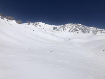
In the last 24 hours, Mount Shasta has received no new snow. Temperatures have been mostly above freezing, ranging from 31 to 47°F. Winds have been light.
Expect wind blasted snow surfaces above treeline. Scouring has occurred down to the dirt. Near and below treeline, warmer temperatures are presenting spring skiing opportunities. No signs of instability have been seen.
Weather and Current Conditions
A ridge of high pressure will keep things clear and dry for the next couple of days. This ridge will begin to crumble late Thursday lining us up for a bit of precipitation this weekend. Winds will be moderate to light above treeline.
Produced in partnership with the Medford NWS
| Weather |
Mostly sunny. |
Clear. |
Sunny. |
| Temperature (°F) |
45 |
27 |
41 |
| Wind (mi/hr) |
North 5-10 |
Northeast 5-10 |
South 5-10 |
| Precipitation SWE / Snowfall (in) |
0.00 / 0 |
0.00 / 0 |
0.00 / 0 |
| Weather |
Mostly sunny |
Clear. |
Sunny. |
| Temperature (°F) |
32 |
31 |
32 |
| Wind (mi/hr) |
North 25-30 |
Northeast 10-15 |
Southwest 10-15 |
| Precipitation SWE / Snowfall (in) |
0.00 / 0 |
0.00 / 0 |
0.00 / 0 |
| Period |
Measured (in) |
Normal (in) |
Percent of Normal (%) |
| From Oct 1, 2025 (the wet season) |
12.90 |
24.93 |
52 |
| Month to Date (since Jun 1, 2026) |
0.12 |
2.66 |
5 |
| Year to Date (since Jan 1, 2026) |
3.97 |
9.72 |
41 |
Disclaimer
This forecast does not apply to Ski Areas or Highways and is for the Mt. Shasta, Castle Lake and Mt. Eddy backcountry. Use this information for guidance only. You may find different conditions in the backcountry and should travel accordingly. This forecast expires 24 hours after the posted time unless otherwise noted.