

You are here
Avalanche Advisory for 2018-03-14 06:30
- EXPIRED ON March 15, 2018 @ 6:30 amPublished on March 14, 2018 @ 6:30 am
- Issued by Aaron Beverly - Mount Shasta Avalanche Center
Bottom Line
Dangerous avalanche conditions exist in the backcountry. Wind slabs are the primary concern near and above treeline. Storm slabs are a secondary concern in sheltered areas near and below treeline.


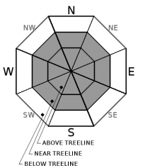
Avalanche Problem 1: Wind Slab
-
Character ?

-
Aspect/Elevation ?
-
Likelihood ?CertainVery LikelyLikelyPossible
 Unlikely
 -
Size ?HistoricVery LargeLargeSmall

With over 2.5 inches of water received since Monday night, over 2 ft of snow has fallen above treeline. This coupled with moderate to strong winds will have led to the formation of wind slabs that will be significant in size and thickness.
Look for wind slabs in leeward terrain near and above treeline. Human triggered and natural wind slab avalanches are likely. Stick to protected or wind scoured areas to avoid the wind slab problem and steer clear of wind loaded slopes 35 degrees and steeper. Stay away from runout zones.
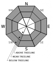
Avalanche Problem 2: Storm Slab
-
Character ?

-
Aspect/Elevation ?
-
Likelihood ?CertainVery LikelyLikelyPossible
Unlikely
-
Size ?HistoricVery LargeLargeSmall
No signs of storm slabs were encountered yesterday afternoon and the configuration of the snowpack was not indicative of a storm slab problem. However, with 6 inches of more snow received last night along with continued snow today, it is wise to continue to be wary of this problem.
Storm slabs form in sheltered areas where new snow falls with light winds.They can occur on any steep open slope, and are often found on several aspects at the same time. They are easiest to trigger during periods of heavy snow and typically stabilize after the storm cycle has ended. Reduce your risk from storm slabs by waiting a day or two after a storm before venturing into steep avalanche terrain.
Forecast Discussion
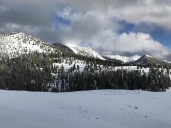
Mount Shasta has received 2.55 inches of water since late Monday night. Though much of this fell in the form of rain below treeline, 2-3 ft has likely come as snow near and above treeline. This is a red flag for avalanches. Conditions may lure sliders and riders out into the backcountry today. If you head out, avoid slopes greater than 35 degrees and the runout zones below them until the snowpack has time to adjust to the new snow.
The Mount Eddy and Castle Lake backcountry have remained mostly below snow levels but should begin seeing snow today through Saturday.
Recent Observations
Snow levels dropped to 5500 ft earlier than expected yesterday bringing 4-10 inches of snow above Bunny Flat by mid afternoon. The Old Ski Bowl weather station is incorrectly reporting 5 inches of new snow. The observed amount at 2 p.m. yesterday was 10 inches. It is uncertain how much snow fell overnight, but snow water equivalent was recorded to be .47 inches since 3 p.m.
Southerly and westerly winds have averaged 16 mph with gusts up to 39.
Observations yesterday saw snow surfaces unaffected by wind up into lower Ski Bowl. Visibility above treeline was limited, but no signs of wet-loose or storm slab problems were observed nor did the they seem likely from snowpack analysis. Snow pack was right side up and showed good stability. New snow was bonding well with the old snow surface.
Skiers reported seeing some wind drifts near treeline on Green Butte Ridge.
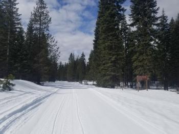
Road was plowed to Bunny Flat by 4 p.m.
Weather and Current Conditions
Weather Summary
A low pressure system will affect the Mount Shasta area today through Saturday keeping snow levels near town and bringing precipitation, the bulk of which will come tomorrow. Expect 1-4 inches today, 1-2 inches tonight, and 2-8 inches tomorrow. Southerly winds are predicted to be unusually light to moderate even at high elevations.
24 Hour Weather Station Data @ 6:00 AM
| Weather Station | Temp (°F) | Wind (mi/hr) | Snow (in) | Comments | ||||||||
|---|---|---|---|---|---|---|---|---|---|---|---|---|
| Cur | Min | Max | Avg | Avg | Max Gust | Dir | Depth | New | Water Equivalent | Settlement | ||
| Mt. Shasta City (3540 ft) | 48 | 34 | 55 | 43 | 4 | SE | ||||||
| Sand Flat (6750 ft) | station down | |||||||||||
| Ski Bowl (7600 ft) | 20 | 20 | 31.5 | 25 | 69 | 16 | 2.01 | 0 | snow numbers are best guesses | |||
| Gray Butte (8000 ft) | 19.5 | 19.5 | 31.5 | 24.5 | 16 | 37 | WNW | |||||
| Castle Lake (5870 ft) | station down | |||||||||||
| Mount Eddy (6509 ft) | 23.5 | 23.5 | 33 | 28 | 1 | 13 | SSE | 35.5 | 0 | 0 | ||
| Ash Creek Bowl (7250 ft) | station down | |||||||||||
| Ash Creek Ridge (7895 ft) | station down |
Two Day Mountain Weather Forecast
Produced in partnership with the Medford NWS
| For 7000 ft to 9000 ft | |||
|---|---|---|---|
|
Wednesday (4 a.m. to 10 p.m.) |
Wednesday Night (10 p.m. to 4 a.m.) |
Thursday (4 a.m. to 10 p.m.) |
|
| Weather | Snow showers. Chance of precipitation is 90%. | Snow showers, mainly before 11pm. Chance of precipitation is 90%. | Snow. Chance of precipitation is 100%. |
| Temperature (°F) | 31 | 21 | 27 |
| Wind (mi/hr) | W 5 mi/hr | W 5 mi/hr | S 10-15 mi/hr |
| Precipitation SWE / Snowfall (in) | / 1-2 | / 1-2 | / 2-4 |
| For 9000 ft to 11000 ft | |||
| Wednesday | Wednesday Night | Thursday | |
| Weather | Snow showers. Wind chill values as low as -4. Chance of precipitation is 80%. | Snow showers, mainly before 11pm. Wind chill values as low as -14. Chance of precipitation is 100%. | Wind chill values as low as -8. Windy. Chance of precipitation is 100%. |
| Temperature (°F) | 12 | 10 | 11 |
| Wind (mi/hr) | SW 5-10 mi/hr | SW 3-4 | S 15-20 mi/hr |
| Precipitation SWE / Snowfall (in) | / 3-4 | / 1-2 | / 6-8 |
Season Precipitation for Mount Shasta City
| Period | Measured (in) | Normal (in) | Percent of Normal (%) |
|---|---|---|---|
| From Oct 1, 2025 (the wet season) | 13.86 | 32.59 | 43 |
| Month to Date (since Jun 1, 2026) | 2.97 | 3.09 | 96 |
| Year to Date (since Jan 1, 2026) | 8.03 | 17.38 | 46 |

