

You are here
Avalanche Advisory for 2018-03-15 06:16
- EXPIRED ON March 16, 2018 @ 6:16 amPublished on March 15, 2018 @ 6:16 am
- Issued by Nick Meyers - Shasta-Trinity National Forest
Bottom Line
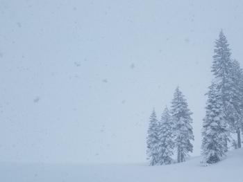
A WINTER STORM WARNING is in effect fromt 9 AM this morning to 8 AM PDT Friday. Southwesterly flow will bring windy conditions and up to a foot of new snow to terrain above 4,000 feet. Expect a spike in avalanche danger as this storm impacts the area. Snow will be heavy at times and whiteout conditions are certain above treeline. Wind slabs remain the primary concern in alpine terrain and CONSIDERABLE danger is possible during the storm.


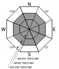
Avalanche Problem 1: Wind Slab
-
Character ?

-
Aspect/Elevation ?
-
Likelihood ?CertainVery LikelyLikelyPossible
 Unlikely
 -
Size ?HistoricVery LargeLargeSmall

Additional, heavy precipitation and moderate winds out of the southwest will continue to load avalanche terrain on Mount Shasta. Wind slabs are likely in leeward terrain, near and above treeline, and could be reactive to triggering. That said, visibility is going to be tough in these most suspect areas. If you do decide to brave the storm and drop in on steep avalanche terrain, be careful. Slab size has the potential to be fatal.
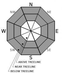
Avalanche Problem 2: Storm Slab
-
Character ?

-
Aspect/Elevation ?
-
Likelihood ?CertainVery LikelyLikelyPossible
Unlikely
-
Size ?HistoricVery LargeLargeSmall
No signs of storm slabs were encountered yesterday and the configuration of the snowpack was not indicative of a storm slab problem. That said, with up to a foot of new snow expected, we think it is wise to keep this problem in mind for the near future.
Storm slabs form in sheltered areas where new snow falls with light winds.They can occur on any steep open slope, and are often found on several aspects at the same time. They are easiest to trigger during periods of heavy snow and typically stabilize after the storm cycle has ended. Reduce your risk from storm slabs by waiting a day or two after a storm before venturing into steep avalanche terrain.
Forecast Discussion
Heavy snow and wind will provide a wintery weather mix for Mount Shasta today. Above treeline terrain remains our greatest concern for backcountry enthusiasts. Expect the avalanche danger to quickly spike as periods of heavy snowfall and wind rapidly load those slopes we all like to slide and ride on.
Recent Observations
Mount Shasta - Southside
- Height of storm snow (HST): 50 cm (20 in), 7600-8500 ft.
- Right side up snowpack.
- New snow well bonded with old snow.
- No signs of storm slabs.
- Little effects of wind. Small cornices and wind pillows on northerly and easterly facing aspects above treeline.
- No obvious signs of instability below and near treeline. Riding rollovers on steep inconsequential slopes yielded no failures.
- Hand tests stubborn to trigger.
- Above treeline: D1 sized point releases in Powder Bowl, several D1 point release and possible D1 slab avalanche off of Sargent's Ridge into Avalanche Gulch.
- Skiers reported minor wind affected snow on Green Butte Ridge and thin zipper crusts on sun facing aspects with 20 cm of ski penetration with 4F hardness.
Castle Lake Area
- Lake frozen with soft edges
- Snowpack still not usable.
- 2 to 4 inches of new storm snow fell on top of the old, rotten, rain soaked snowpack.
- Snow flurries mixed with sunny donut holes brought intermittent new snow accumulation that melted as fast as it fell.
- One to two feet of snow on the ground, numerous rocks and brush obstacles showing
- A few small point releases off Middle Peak
- Continuing to troubleshoot weather station connectivity
Weather and Current Conditions
Weather Summary
A WINTER STORM WARNING is in effect from 9 AM this morning to 8 AM PDT Friday. A closed low will gradually settle southeastward along the Pacific Northwest coast. The frontal system will move onshore today, followed by additional short wave disturbances tonight into Friday. The focus for precipitation will be in the favored terrain areas of SW Oregon and Northern California, including the Mount Shasta region. Periods of moderate to heavy snow will move into these areas this morning, then continue this afternoon and into tonight. Snow levels around or just below 2,000 feet this morning will rise a bit today, but will hover near 2,500 to 3,500 feet. The lowest snow levels will be where the precipitation is the heaviest, which could be near Mount Shasta. Expect heavy, wet snow out of this one with about an inch of water to fall over the next 36 hours. A foot of new snow is likely above 4,000 feet. Winds will be moderate out of the southwest near and above treeline.
24 Hour Weather Station Data @ 4:00 AM
| Weather Station | Temp (°F) | Wind (mi/hr) | Snow (in) | Comments | ||||||||
|---|---|---|---|---|---|---|---|---|---|---|---|---|
| Cur | Min | Max | Avg | Avg | Max Gust | Dir | Depth | New | Water Equivalent | Settlement | ||
| Mt. Shasta City (3540 ft) | 33 | 32 | 42 | 35.5 | 2 | N | ||||||
| Sand Flat (6750 ft) | station down | |||||||||||
| Ski Bowl (7600 ft) | 14.5 | 14.5 | 30 | 20.5 | 73.2 | 0.5 | 0.06 | 1.7 | ||||
| Gray Butte (8000 ft) | 14 | 14 | 27.5 | 19.5 | 8 | 18 | NW | |||||
| Castle Lake (5870 ft) | station down | |||||||||||
| Mount Eddy (6509 ft) | 16.5 | 15 | 28.5 | 22 | 1 | 7 | SE | 43 | 1 | .5 | ||
| Ash Creek Bowl (7250 ft) | station down | |||||||||||
| Ash Creek Ridge (7895 ft) | station down |
Two Day Mountain Weather Forecast
Produced in partnership with the Medford NWS
| For 7000 ft to 9000 ft | |||
|---|---|---|---|
|
Thursday (4 a.m. to 10 p.m.) |
Thursday Night (10 p.m. to 4 a.m.) |
Friday (4 a.m. to 10 p.m.) |
|
| Weather | Snow. Breezy. Chance of snow 100%. Snow level near town or lower. | Snow. Chance of snow 100%. Snow level near town or lower. | Snow showers. Chance of snow 90%. Snow level near town or lower. |
| Temperature (°F) | 27 | 21 | 29 |
| Wind (mi/hr) | S 10-15 mi/hr | S 5-10 mi/hr | S 5-10 mi/hr |
| Precipitation SWE / Snowfall (in) | / 5-10 | / 4-8 | / 3-5 |
| For 9000 ft to 11000 ft | |||
| Thursday | Thursday Night | Friday | |
| Weather | Snow and windy. Snow heavy at times.Wind chill as low as -19 F. Chance of snow 100%. | Snow and windy. Snow heavy at times.Wind chill as low as -20 F. Chance of snow 100%. | Snow showers and breezy. Snow heavy at times.Wind chill as low as -18 F. Chance of snow 100%. |
| Temperature (°F) | 12 | 8 | 10 |
| Wind (mi/hr) | SW 20-30 mi/hr | SW 8-12 | SW 20-30 mi/hr |
| Precipitation SWE / Snowfall (in) | / 8-12 | / 7-9 | / 4-8 |
Season Precipitation for Mount Shasta City
| Period | Measured (in) | Normal (in) | Percent of Normal (%) |
|---|---|---|---|
| From Oct 1, 2025 (the wet season) | 13.87 | 32.80 | 42 |
| Month to Date (since Jun 1, 2026) | 2.98 | 3.30 | 90 |
| Year to Date (since Jan 1, 2026) | 8.04 | 17.59 | 46 |

