

You are here
Avalanche Advisory for 2018-12-03 06:04
- EXPIRED ON December 4, 2018 @ 6:04 amPublished on December 3, 2018 @ 6:04 am
- Issued by Nick Meyers - Shasta-Trinity National Forest
Bottom Line
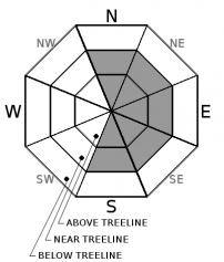
MODERATE avalanche danger exists near and above treeline today due to lingering wind slabs. Human triggered avalanches will remain possible. If any doubts exist about the stability of a slope, avoid it and move on to something lower angle. LOW danger remains below treeline. Rocks and other hazards still exists so be careful.


Avalanche Problem 1: Wind Slab
-
Character ?

-
Aspect/Elevation ?
-
Likelihood ?CertainVery LikelyLikelyPossible
 Unlikely
 -
Size ?HistoricVery LargeLargeSmall

Continue to be mindful of the wind slab problem today. Wind slabs will mostly be encountered on SE-E-NE aspects but mountain winds are variable so look for them wherever there is evidence of wind loading.
Evaluate snow and terrain carefully. Avoid wind slabs by traveling in windward areas where snow surfaces have been eroded. Avoid slopes greater than 35 degrees where wind loading has occurred. Evaluate conditions as you travel in safe terrain by looking for signs of the wind slab problem:
- Smooth rounded wind pillows
- Hollow sounding snow
- Harder snow atop softer snow
- Shooting cracks
Forecast Discussion
Temperatures will remain chilly today. If venturing out into the backcountry, bring appropriate clothing to stay warm!
Recent Observations
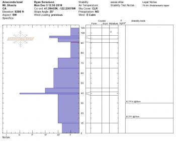
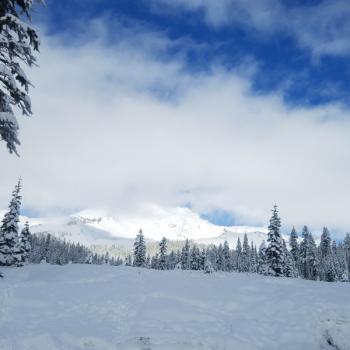
A series of winter storms beginning on Thanksgiving (November 22, 2018) has brought 50 inches of snow above 7000 ft. Current height of snow (HN) at the Old Ski Bowl weather station is 41 inches.
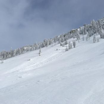
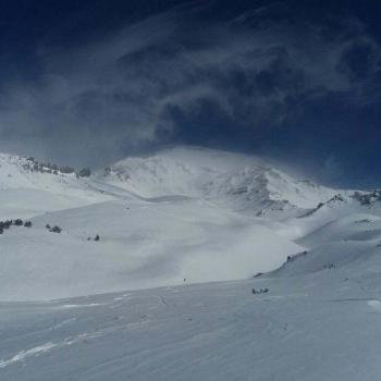
Yesterday brought clear skis, light winds and cool temps to the forecast area. Above 8,500 feet is wind affected. No new avalanches were observed.
Early season obstacles are mostly covered however some hazards still exist. Tread lightly.
Weather and Current Conditions
Weather Summary
Dry and chilly conditions continue today accompanied by light winds at lower elevations and moderate winds at upper elevations. A small low pressure system may bring a chance of moisture back to the region Tuesday/Wednesday. Dry weather will follow for Thursday and Friday.
24 Hour Weather Station Data @ 5:00 AM
| Weather Station | Temp (°F) | Wind (mi/hr) | Snow (in) | Comments | ||||||||
|---|---|---|---|---|---|---|---|---|---|---|---|---|
| Cur | Min | Max | Avg | Avg | Max Gust | Dir | Depth | New | Water Equivalent | Settlement | ||
| Mt. Shasta City (3540 ft) | 19 | 19 | 39 | 27.5 | 1 | N | ||||||
| Sand Flat (6750 ft) | 10 | 10 | 24 | 16 | 31 | 1 | 0 | 2 | ||||
| Ski Bowl (7600 ft) | 16.5 | 12 | 28 | 16 | 41.3 | 0.8 | 0 | 1.1 | ||||
| Gray Butte (8000 ft) | 13.5 | 11.5 | 23.5 | 15.5 | 3 | 12 | ESE | |||||
| Castle Lake (5870 ft) | 0 | 0 | 0 | 0 | 0 | 0 | 0 | station down | ||||
| Mount Eddy (6509 ft) | 12.5 | 9.5 | 23 | 15.5 | 2 | 7 | WSW | 34 | 0.2 | 2.5 | ||
| Ash Creek Bowl (7250 ft) | station down | |||||||||||
| Ash Creek Ridge (7895 ft) | station down |
Two Day Mountain Weather Forecast
Produced in partnership with the Medford NWS
| For 7000 ft to 9000 ft | |||
|---|---|---|---|
|
Monday (4 a.m. to 10 p.m.) |
Monday Night (10 p.m. to 4 a.m.) |
Tuesday (4 a.m. to 10 p.m.) |
|
| Weather | Sunny | A 30 percent chance of snow, mainly after 4am. Increasing clouds. | A 30 percent chance of snow, mainly before 10am. Mostly cloudy. |
| Temperature (°F) | 28 | 22 | 31 |
| Wind (mi/hr) | Calm, becoming SE in the afternoon 0-5 | E/SE 5-10 | SE 10-15 |
| Precipitation SWE / Snowfall (in) | / 0 | / 0-.5 | / 0-.5 |
| For 9000 ft to 11000 ft | |||
| Monday | Monday Night | Tuesday | |
| Weather | Sunny and windy | A 30 percent chance of snow, mainly after 4am. Increasing clouds. | A 30 percent chance of snow, mainly before 10am. Mostly cloudy. |
| Temperature (°F) | 19 | 21 | 22 |
| Wind (mi/hr) | SW 10-15 | W/SW 0 | S 15-20 |
| Precipitation SWE / Snowfall (in) | / 0 | / 0-.5 | / 0-.5 |
Season Precipitation for Mount Shasta City
| Period | Measured (in) | Normal (in) | Percent of Normal (%) |
|---|---|---|---|
| From Oct 1, 2025 (the wet season) | 5.07 | 7.81 | 65 |
| Month to Date (since Jun 1, 2026) | 0.34 | 0.45 | 76 |
| Year to Date (since Jan 1, 2026) | 20.35 | 35.81 | 57 |

