

You are here
Avalanche Advisory for 2018-12-06 06:46
- EXPIRED ON December 7, 2018 @ 6:46 amPublished on December 6, 2018 @ 6:46 am
- Issued by Nick Meyers - Shasta-Trinity National Forest
Bottom Line
The avalanche danger is LOW at all elevations and aspects. Exercise normal caution. LOW avalanche danger does not mean NO avalanche danger. Evaluate snow and terrain carefully as you travel in the backcountry.
An ice axe, crampons, and helmet will be prudent if climbing above treeline.
Shallow buried rocks and trees exist everywhere.


Avalanche Problem 1: Normal Caution
-
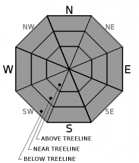
Character ?

-
Aspect/Elevation ?
-
Likelihood ?CertainVery LikelyLikelyPossible
 Unlikely
Generally safe avalanche conditions exist in the backcountry. Both natural and human triggered avalanches are unlikely. Exercise NORMAL CAUTION and watch for the odd wind slab(s) on leeward slopes. Wind pillows, hollow sounding snow, shooting cracks, and harder snow atop softer snow are signs that a wind slab may be nearby.
Forecast Discussion
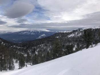
Snow on the ground means sliders, riders and perhaps some climbers are out and about. Winds hammered the mountain near the beginning of December, scouring ridgelines and creating firm snow surfaces above treeline. Many classic avalanche starting zones are a salt and pepper mix of snow and rock. Use normal caution and instead of avalanches, think slide for life. Lower down, rocks and trees lurk.
Sheltered, shady and cold aspects retain soft snow. Sunny, southerly aspects have been impacted by recent sun, but low sun angle and short days have limited total destruction.
Approximately 48 more hours of clear and calm weather will be followed by an active period of what we like to call... WINTER![]() Count them down! Stay tuned, be safe, have fun.
Count them down! Stay tuned, be safe, have fun.
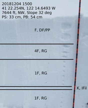
Recent Observations
Check out all recent observation reports below from Mount Shasta, Castle Lake and Mount Eddy for a full tour of the forecast area. Despite a couple small avalanches on Gray Butte (see observation), our winter snowpack rests with confidence and is set up well for more snow in the future. Since November 27th, daytime highs have not gone above 32.5 degrees F at the Old Ski Bowl, Gray Butte and Mount Eddy weather stations. These chilly temps are a testament to the persistently soft snow surface conditions that many have enjoyed. Many portions of our terrain, such as the Castle Lake area, still need more snow to pose avalanche threat.
Weather and Current Conditions
Weather Summary
Dry, sunny and calm weather will prevail for the near future with low level fog and smoke in the valleys. Winter stoke will continue however as a progressing pattern is evolving across the North Pacific with a very active jet stream. A weak front will move in Friday night into Saturday. While fairly weak, it will mark the beginning of an active period of weather across the Pacific Northwest. This period will feature several frontal systems that will impact our weather in the form of wind, rain and snow. Snow levels appear to remain mostly in the 4,000 to 6,000 foot range, dipping lower at times.
Curious about the status of EL NINO? Click HERE
24 Hour Weather Station Data @ 4:00 AM
| Weather Station | Temp (°F) | Wind (mi/hr) | Snow (in) | Comments | ||||||||
|---|---|---|---|---|---|---|---|---|---|---|---|---|
| Cur | Min | Max | Avg | Avg | Max Gust | Dir | Depth | New | Water Equivalent | Settlement | ||
| Mt. Shasta City (3540 ft) | 26 | 26 | 45 | 35 | 0 | N | ||||||
| Sand Flat (6750 ft) | 20 | 20 | 33 | 27 | 28 | 0 | 0 | 1 | ||||
| Ski Bowl (7600 ft) | 28 | 23 | 31.5 | 27 | 36 | 1.8 | 0.01 | 2.4 | ||||
| Gray Butte (8000 ft) | 28 | 21.5 | 28 | 25.5 | 12 | 31 | E | |||||
| Castle Lake (5870 ft) | 0 | 0 | 0 | 0 | 0 | 0 | 0 | station down | ||||
| Mount Eddy (6509 ft) | 23 | 21 | 33.5 | 25.5 | 2 | 5 | WSW | 31.3 | 1.2 | 0 | ||
| Ash Creek Bowl (7250 ft) | station down | |||||||||||
| Ash Creek Ridge (7895 ft) | station down |
Two Day Mountain Weather Forecast
Produced in partnership with the Medford NWS
| For 7000 ft to 9000 ft | |||
|---|---|---|---|
|
Thursday (4 a.m. to 10 p.m.) |
Thursday Night (10 p.m. to 4 a.m.) |
Friday (4 a.m. to 10 p.m.) |
|
| Weather | Sunny | Mostly clear | Sunny |
| Temperature (°F) | 33 | 24 | 35 |
| Wind (mi/hr) | E 0-5 | E 0-5 | SE 0-5 |
| Precipitation SWE / Snowfall (in) | / 0 | / 0 | / 0 |
| For 9000 ft to 11000 ft | |||
| Thursday | Thursday Night | Friday | |
| Weather | Sunny | Mostly clear | Mostly sunny then partly cloudy and breezy |
| Temperature (°F) | 24 | 24 | 27 |
| Wind (mi/hr) | NE 5-10 | NW 0 | W 10-15 |
| Precipitation SWE / Snowfall (in) | / 0 | / 0 | / 0 |
Season Precipitation for Mount Shasta City
| Period | Measured (in) | Normal (in) | Percent of Normal (%) |
|---|---|---|---|
| From Oct 1, 2025 (the wet season) | 5.08 | 8.49 | 60 |
| Month to Date (since Jun 1, 2026) | 0.35 | 1.13 | 31 |
| Year to Date (since Jan 1, 2026) | 20.36 | 36.49 | 56 |

