

You are here
Avalanche Forecast for 2018-12-18 06:00
- EXPIRED ON December 19, 2018 @ 6:00 amPublished on December 18, 2018 @ 6:00 am
- Issued by Aaron Beverly - Mount Shasta Avalanche Center
Bottom Line
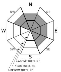
The avalanche danger is MODERATE above treeline due to the potential of wind slabs. When in doubt, avoid leeward slopes greater than 35 degrees. Avalanche danger is LOW near and below treeline.


Avalanche Problem 1: Wind Slab
-
Character ?

-
Aspect/Elevation ?
-
Likelihood ?CertainVery LikelyLikelyPossible
 Unlikely
 -
Size ?HistoricVery LargeLargeSmall

No significant signs of a wind slab problem were observed yesterday near or below treeline. This problem may lurk higher in the less explored alpine region where slabs could persist and grow as moderate to strong westerly winds continue to transport the snow received Sunday along with the few inches expected today. Pay particular attention to northerly and easterly aspects where the most productive winds have blown snow.
Signs of wind slabs are blowing snow, wind pillows, shooting cracks and/or smooth, round, hollow sounding snow. Be suspicious of any steep slope with recent deposits of wind drifted snow. Weak layers could include old snow/new snow interfaces and/or density changes in the new snow.
Forecast Discussion
All signs point to a snowpack that is quickly stabilizing after Sunday's storm. Today's warm storm with meager amount of snow accumulation is not expected to change this. But continue to evaluate snow and terrain carefully. Natural avalanches are unlikely but human-triggered avalanches are possible.
Recent Observations
Over an inch of snow fell last night near the Old Ski Bowl. Winds have been westerly averaging 13 mi/hr. Height of snow at the Old Ski Bowl is 45 inches.
The wind affect on the 13 inches of snow yesterday was less than expected. Slight wind effects were seen in open areas but no notable wind slab growth was observed. Snowpack is right side up near treeline. No natural avalanches were seen near or above treeline. A widespread rain crust exists below new snow up to at least 8000 ft but the snow is bonding well with it. See yesterday's observation for details.
Weather and Current Conditions
Weather Summary
Mount Shasta will catch the far southern effects of an atmospheric river hitting the Pacific Northwest today. Expect a few inches of snow at high elevations. Snow levels will start near 5600 ft today and rise to 6800 ft by tonight.
The 10 day outlook continues to look mostly wet with above average temperatures.
24 Hour Weather Station Data @ 4:00 AM
| Weather Station | Temp (°F) | Wind (mi/hr) | Snow (in) | Comments | ||||||||
|---|---|---|---|---|---|---|---|---|---|---|---|---|
| Cur | Min | Max | Avg | Avg | Max Gust | Dir | Depth | New | Water Equivalent | Settlement | ||
| Mt. Shasta City (3540 ft) | 40 | 34 | 41 | 38.5 | 3 | N | ||||||
| Sand Flat (6750 ft) | 29 | 21 | 31 | 27 | 33 | 1 | .08 | 2 | ||||
| Ski Bowl (7600 ft) | 25.5 | 18.5 | 26.5 | 23.5 | 44.8 | 2 | 0.06 | 2.4 | ||||
| Gray Butte (8000 ft) | 24.5 | 20.5 | 26.5 | 23 | 13 | 25 | W | |||||
| Castle Lake (5870 ft) | station down | |||||||||||
| Mount Eddy (6509 ft) | 22.5 | 22.5 | 33.5 | 31 | 1 | 18 | 32.8 | 4 | 0 | |||
| Ash Creek Bowl (7250 ft) | station down | |||||||||||
| Ash Creek Ridge (7895 ft) | station down |
Two Day Mountain Weather Forecast
Produced in partnership with the Medford NWS
| For 7000 ft to 9000 ft | |||
|---|---|---|---|
|
Tuesday (4 a.m. to 10 p.m.) |
Tuesday Night (10 p.m. to 4 a.m.) |
Wednesday (4 a.m. to 10 p.m.) |
|
| Weather | Snow before 4 p.m., then rain and snow. High near 36. Breezy and gusty. Chance of precipitation is 100%. | Rain and snow showers. Breezy and gusty. Chance of precipitation is 90%. | A 20 percent chance of snow showers before 10 a.m. Partly sunny. |
| Temperature (°F) | 39 | 30 | 43 |
| Wind (mi/hr) | S 15-20 | SW 10-15 | SE 5-10 |
| Precipitation SWE / Snowfall (in) | / 1-2 | / 1-2 | / 0 |
| For 9000 ft to 11000 ft | |||
| Tuesday | Tuesday Night | Wednesday | |
| Weather | Snow. Low wind chills. Windy and gusty. Chance of precipitation is 100%. | Snow showers, mainly before 4 a.m. Low wind chills. Windy and gusty. Chance of precipitation is 90%. | A 20 percent chance of snow showers before 10 a.m. Partly sunny. Windy and gusty. |
| Temperature (°F) | 27 | 22 | 33 |
| Wind (mi/hr) | W 45-55 | W 2-3 | W 20-30 |
| Precipitation SWE / Snowfall (in) | / 2-3 | / 1-2 | / 0 |
Season Precipitation for Mount Shasta City
| Period | Measured (in) | Normal (in) | Percent of Normal (%) |
|---|---|---|---|
| From Oct 1, 2025 (the wet season) | 7.30 | 11.20 | 65 |
| Month to Date (since Jun 1, 2026) | 2.57 | 3.84 | 67 |
| Year to Date (since Jan 1, 2026) | 22.58 | 39.20 | 58 |

