

You are here
Avalanche Forecast for 2019-03-03 06:00
- EXPIRED ON March 4, 2019 @ 6:00 amPublished on March 3, 2019 @ 6:00 am
- Issued by Ryan Sorenson - Mount Shasta Avalanche Center
Bottom Line
Variable snow surfaces and low avalanche risk exist in the Mount Shasta backcountry today. Use normal caution. There is a slight concern for wind slab avalanches on isolated steep terrain above treeline. These wind slabs will remain small and stubborn due to calm winds and warmer temperatures seen yesterday. Similar conditions expected today will further decrease the likelihood of wind slab formation and triggering. Loose wet avalanches could be a concern later in the day on solar aspects.


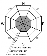
Avalanche Problem 1: Wind Slab
-
Character ?

-
Aspect/Elevation ?
-
Likelihood ?CertainVery LikelyLikelyPossible
 Unlikely
 -
Size ?HistoricVery LargeLargeSmall

Any new snow received yesterday settled into the snowpack quickly. Old ski bowl recorded 2 inches of new snow but 3 inches of settlement. A warming trend was observed yesterday with light misty rain up to 6,500 feet on Gray Butte. A maximum temperature of 33.5 degrees F was recorded at 8,000 feet on Mount Shasta yesterday afternoon. A low of 25 degrees was recorded last night. This large temperature swing has likely settled out any unstable lingering layers within the snowpack. Any remaining instabilities could be found at alpine elevations above 10,000 feet, or in steep complex terrain in the Eddies above 6,000 feet. Natural avalanches are unlikely. New wind slabs could form above treeline on isolated terrain features today if higher winds are seen; however, winds are expected to be calm to light today and there is little available snow for transport remaining.
Use normal caution and pay attention if the wind is blowing and depositing snow. Look for signs of wind slabs and cornices as you travel in safe terrain. Stay away from areas where shooting cracks, blocking, and whumphing are observed. Other signs of wind slabs include previously drifted snow and chalky, hollow sounding snow. Unsupported slopes, gullies, couloirs, cliffy areas and other complex or extreme terrain represent the best places to find a lingering wind slab. If wind slabs are encountered keep travel to lower angle windward slopes to return to safety.
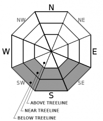
Avalanche Problem 2: Loose Wet
-
Character ?

-
Aspect/Elevation ?
-
Likelihood ?CertainVery LikelyLikelyPossible
Unlikely
-
Size ?HistoricVery LargeLargeSmall
Warming temperatures could raise the concern for loose wet avalanches on solar aspects this afternoon. Wet loose snow slides consist of dense, heavy snow and can sometimes grow to large and destructive sizes. Keep an eye out for roller balls as these are a sign that loose wet "sluffs" are possible. Very few people are killed by loose snow avalanches because they tend to be small and they tend to fracture below you as you cross a slope; however, terrain traps and cliffs could increase the danger of these seemly harmless avalanches. Staying off steep south-facing slopes late in the day is the best way to avoid loose wet avalanches.
Recent Observations
In the last 24 hours, temperatures have varied with a maximum temperature of 33.5 degrees F near and a minimum of 25 degrees F at 8,000 feet on Mount Shasta. Calm wind out of the northwest was recorded yesterday with an average wind speed of 5 mi/hr, with a max wind speed of 12 mi/hr on Mount Shasta. Temperatures at Castle Lake ranged from 27 to 31.5 degrees F in the last 24 hours near 5,800 feet.
Conditions on Gray Butte yesterday:
- Winds: Calm, West
- Temp: Warming temperatures above freezing
- Surface textures were variable with creamy warm soft snow over a supportable crust above 7,000 feet.
- Wet heavy snow was observed below 7,000 feet.
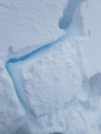
- Settlement cones were observed around tree wells.
- Warming temperatures caused trees to shed large amounts of snow below 7,000 feet.
- No signs of instabilities.
- Road: Everitt Memorial and Castle Lake Roads are closed.
Weather and Current Conditions
Weather Summary
Mixed cloud layers are expected today as cooler inland air masses meet warm wet coastal air from a weak lingering weather front. This will allow isolated rain and snow showers to linger in the forecast area today. Snow accumulation of 1 inch by tomorrow morning is likely. Snow levels will rise to 5,000 feet this afternoon and drop to 4,700 feet on Mount Shasta tonight. Snow level is expected to be at 4,100 feet tomorrow.
Variable light wind will mostly blow out of the north today. Light wind out of the northwest will blow above treeline throughout the day on Mount Shasta. The Eddies will see calm to light wind from the northeast today.
The next storm is expected to move in on Tuesday night. This is another atmospheric river event that will bring nearly 2 inches of water and upwards of 2 more feet of snow. Snow levels could start as low as 3,800 feet but are expected to rise throughout the course of the storm.
24 Hour Weather Station Data @ 5:00 AM
| Weather Station | Temp (°F) | Wind (mi/hr) | Snow (in) | Comments | ||||||||
|---|---|---|---|---|---|---|---|---|---|---|---|---|
| Cur | Min | Max | Avg | Avg | Max Gust | Dir | Depth | New | Water Equivalent | Settlement | ||
| Mt. Shasta City (3540 ft) | 35 | 33 | 42 | 35.5 | 0 | N | ||||||
| Sand Flat (6750 ft) | ||||||||||||
| Ski Bowl (7600 ft) | 26.5 | 25.5 | 37 | 29.5 | 180 | 2 | 0.33 | 3 | ||||
| Gray Butte (8000 ft) | 25 | 25 | 33.5 | 28 | 5 | 18 | WNW | |||||
| Castle Lake (5870 ft) | 31.5 | 26.5 | 37.5 | 31.5 | 144 | 2 | 4 | |||||
| Mount Eddy (6509 ft) | ||||||||||||
| Ash Creek Bowl (7250 ft) | ||||||||||||
| Ash Creek Ridge (7895 ft) |
Two Day Mountain Weather Forecast
Produced in partnership with the Medford NWS
| For 7000 ft to 9000 ft | |||
|---|---|---|---|
|
Sunday (4 a.m. to 10 p.m.) |
Sunday Night (10 p.m. to 4 a.m.) |
Monday (4 a.m. to 10 p.m.) |
|
| Weather | Cloudy, with snow and rain showers possible. | Mostly cloudy with a chance of snow and rain showers. | Mostly clear in the morning then increasing clouds and a slight chance of snow in the afternoon. |
| Temperature (°F) | 37 | 25 | 35 |
| Wind (mi/hr) | North 0-5 | West 0-5 | Southwest 0-5 |
| Precipitation SWE / Snowfall (in) | / 0-1 | / 0-1 | / 0-1 |
| For 9000 ft to 11000 ft | |||
| Sunday | Sunday Night | Monday | |
| Weather | Cloudy with snow showers possible. | Slight chance of snow showers in the evening. | Mostly clear in the morning then increasing clouds and a slight chance of snow in the afternoon. |
| Temperature (°F) | 25 | 15 | 20 |
| Wind (mi/hr) | Northwest 0-10 | West 0-1 | West 5-10 |
| Precipitation SWE / Snowfall (in) | / 0-1 | / 0-1 | / 0-1 |
Season Precipitation for Mount Shasta City
| Period | Measured (in) | Normal (in) | Percent of Normal (%) |
|---|---|---|---|
| From Oct 1, 2025 (the wet season) | 29.66 | 30.03 | 99 |
| Month to Date (since Jun 1, 2026) | 0.13 | 0.53 | 25 |
| Year to Date (since Jan 1, 2026) | 21.25 | 14.82 | 143 |

