

You are here
Avalanche Forecast for 2019-03-06 06:30
- EXPIRED ON March 7, 2019 @ 6:30 amPublished on March 6, 2019 @ 6:30 am
- Issued by Aaron Beverly - Mount Shasta Avalanche Center
Bottom Line
Human-triggered wind slab and storm slab avalanches are possible today. Evaluate the snowpack carefully as you travel in safe terrain. Avoid steep slopes greater than 35 degrees. Roads to Bunny Flat and Castle Lake are projected to open by Friday.


Avalanche Problem 1: Wind Slab
-
Character ?

-
Aspect/Elevation ?
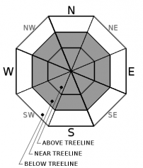
-
Likelihood ?CertainVery LikelyLikelyPossible
 Unlikely
 -
Size ?HistoricVery LargeLargeSmall

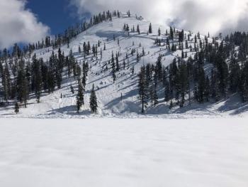
In the last 24 hours we have received close to 7 inches of new snow; 5-11 inches is expected in the next 24 hours. South winds have been light, though the Old Ski Bowl weather station tends to report low numbers with southerly flows. Winds may have been significantly higher above treeline. Expect wind slabs primarily on W-N-E aspects but mountain winds can be variable so pay attention to where leeward areas reside. Stay away from slopes greater than 35 degrees that have been loaded. Signs that wind slabs may be nearby are: shooting cracks, blocking, whumphing; convex pillows of wind-drifted snow; chalky, hollow sounding snow.
Avalanche Problem 2: Storm Slab
-
Character ?

-
Aspect/Elevation ?
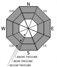
-
Likelihood ?CertainVery LikelyLikelyPossible
Unlikely
-
Size ?HistoricVery LargeLargeSmall
New heavy snow near and below treeline sits atop a thick crust. More heavy snow is on the way today. On slopes near and above 40 degrees, this combination could create the potential for storm slab avalanches failing at the old/new snow interface. This problem will be short lived, but be aware of it today when traveling near and below treeline.
Forecast Discussion
Roads to Bunny Flat and Castle Lake are projected to open by 3/8/19. These projections should not be used to make expensive travel plan decisions. Weekend visitors should have alternative recreational plans in mind in case they do not open.
Recent Observations
Height of snow in the Old Ski Bowl is 180 inches. In the last 24 hours, 6-7 inches of new snow fell. Temperatures ranged from 22 to 29 degrees. Southerly winds were light, averaging 7 mi/hr and gusting up to 25.
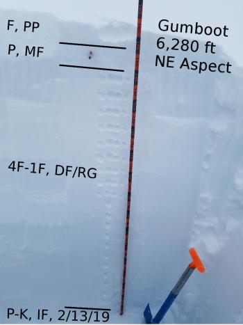
A thick widespread melt/freeze crust exists around 6,400 feet near Gumboot and Cliff Lake. New snow falling atop this crust yesterday was moist. Column tests yielded consistent, moderate failures just below it on old 4F hard decomposing fragments. Extended columns tests did not propagate. Deep tap tests yielded no results on the old 2/13/19 rain crust.

Weather and Current Conditions
Weather Summary
Low pressure continues to affect the area today. Precipitation will gradually taper off after 10 a.m. as a warm front moves on to the northeast.
Over the next 24 hours, expect 5-11 inches of snow with much of that falling by 10 a.m. South winds will be light to moderate below treeline and could be strong above. Snow levels will be near 5,500 feet today, gradually dropping to town by tomorrow.
Milder weather with a mix of sun and snow showers will prevail for several days after today's storm dissipates.
24 Hour Weather Station Data @ 6:00 AM
| Weather Station | Temp (°F) | Wind (mi/hr) | Snow (in) | Comments | ||||||||
|---|---|---|---|---|---|---|---|---|---|---|---|---|
| Cur | Min | Max | Avg | Avg | Max Gust | Dir | Depth | New | Water Equivalent | Settlement | ||
| Mt. Shasta City (3540 ft) | 35 | 32 | 39 | 35.5 | 0 | N | ||||||
| Sand Flat (6750 ft) | ||||||||||||
| Ski Bowl (7600 ft) | 27 | 22 | 29 | 26 | 183.4 | 7 | 1.5 | 0.8 | ||||
| Gray Butte (8000 ft) | 26.5 | 22 | 26.5 | 25 | 8 | 25 | SSE | |||||
| Castle Lake (5870 ft) | 29 | 28.5 | 34 | 31 | 142.8 | 5.1 | 0.8 | |||||
| Mount Eddy (6509 ft) | ||||||||||||
| Ash Creek Bowl (7250 ft) | ||||||||||||
| Ash Creek Ridge (7895 ft) |
Two Day Mountain Weather Forecast
Produced in partnership with the Medford NWS
| For 7000 ft to 9000 ft | |||
|---|---|---|---|
|
Wednesday (4 a.m. to 10 p.m.) |
Wednesday Night (10 p.m. to 4 a.m.) |
Thursday (4 a.m. to 10 p.m.) |
|
| Weather | Snow before 10 a.m., then snow showers after 10 a.m. The snow could be heavy at times. Chance of precipitation is 100%. | Snow showers likely. Cloudy, then gradually becoming partly cloudy. Chance of precipitation is 70%. | A 30 percent chance of snow showers. Partly sunny. |
| Temperature (°F) | 34 | 23 | 29 |
| Wind (mi/hr) | South 10-15 | Southwest 5-10 | Southwest 5-10 |
| Precipitation SWE / Snowfall (in) | / 4-7 | / 1-3 | / 1-2 |
| For 9000 ft to 11000 ft | |||
| Wednesday | Wednesday Night | Thursday | |
| Weather | Snow before 10 a.m., then snow showers after 10 a.m. The snow could be heavy at times. Windy and gusty. Chance of precipitation is 100%. | Snow showers likely. Mostly cloudy. Windy and gusty. Chance of precipitation is 70%. | A 30 percent chance of snow showers. Partly sunny. |
| Temperature (°F) | 21 | 21 | 22 |
| Wind (mi/hr) | South 35-45 | South 5-8 | Southwest 25-30 |
| Precipitation SWE / Snowfall (in) | / 5-8 | / 1-3 | / 1-3 |
Season Precipitation for Mount Shasta City
| Period | Measured (in) | Normal (in) | Percent of Normal (%) |
|---|---|---|---|
| From Oct 1, 2025 (the wet season) | 30.09 | 30.77 | 98 |
| Month to Date (since Jun 1, 2026) | 0.56 | 1.27 | 44 |
| Year to Date (since Jan 1, 2026) | 21.68 | 15.56 | 139 |

