

You are here
Avalanche Forecast for 2019-03-07 06:03
- EXPIRED ON March 8, 2019 @ 6:03 amPublished on March 7, 2019 @ 6:03 am
- Issued by Nick Meyers - Shasta-Trinity National Forest
Bottom Line
Human-triggered wind slab and storm slab avalanches are possible today. Evaluate the snowpack carefully with visual observations, hand pits, and stability tests. Avoid steep, open slopes as any avalanche will be heavy, wet and pack some punch. Recent observations have shown the ability for avalanches to propagate across entire slopes and potentially gouge down into deeper snow layers.


Avalanche Problem 1: Wind Slab
-
Character ?

-
Aspect/Elevation ?
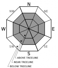
-
Likelihood ?CertainVery LikelyLikelyPossible
 Unlikely
 -
Size ?HistoricVery LargeLargeSmall

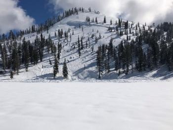
Isolated wind slabs up to several feet thick were observed on primarily NW-N-NE-E-SE aspects, near and above treeline yesterday. More widespread wind slab formation has been limited due to the heavy, wet nature of the recent storm snow. Small cornices, shooting cracks, whumphing, and hollow snow were encountered along ridgelines near treeline on Gray Butte with moderate, gusty winds out of the southwest. Uncertainty exists for above treeline terrain due to poor visibility and limited access. Human triggered, upside down (heavy snow on top of lighter snow) wind slabs are possible today. Avoid steep, wind loaded terrain and areas below cornices.
Avalanche Problem 2: Storm Slab
-
Character ?

-
Aspect/Elevation ?
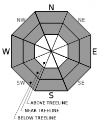
-
Likelihood ?CertainVery LikelyLikelyPossible
Unlikely
-
Size ?HistoricVery LargeLargeSmall
Human triggered storm slabs are possible today. Upside down, new storm snow displayed unstable characteristics yesterday. It is uncertain how long this problem will last. A cold front moving in may help lock up the moist storm snow, but don't count on it for today. Proceed with caution onto steep, open slopes below and near treeline. Simple hand pits and other stability tests may be useful in assessing storm slab stability.
Forecast Discussion
If today is anything like yesterday, human triggered slabs are possible in avalanche terrain. Be careful. As mentioned already, it's uncertain how long instabilities will last. Colder temps may help lock things up in the near future. Lower elevation terrain and snowpack is generally safe due to rain on snow. Overall, snow surface conditions are thick, smooth and potentially knee twisting. Better snow can be found above 7,500 feet.
Roads to Bunny Flat and Castle Lake are projected to open by 3/8/19. These projections should not be used to make expensive travel plan decisions. Weekend visitors should have alternative recreational plans in mind in case they do not open.
Recent Observations
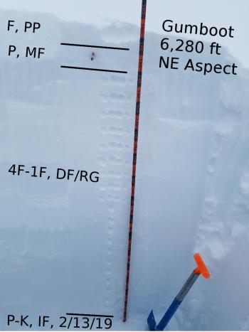
- New snow totals for our recent storm beginning on Tuesday evening and lasting through yesterday afternoon: 12-15 inches
- Storm snow sits on top of widespread, thick crust
- Upside down storm snow layering observed: moist, heavy snow on top, dryer snow below
- Near and above treeline, numerous, easy propagating extended column tests on south and east aspects, within new snow, 10-12 inches down from surface (ECTP5/6)
- Whoomphing, shooting cracks, hollow pockets, drum-like wind slabs all observed on Gray Butte yesterday
- Intentional cornice triggered avalanche off the top of Gray Butte. (click here for observation)

Weather and Current Conditions
Weather Summary
Lingering, isolated showers will give way to partly cloudy skies today. A trace of snow is possible. Snow levels will bump around the 3,000 to 4,000 foot elevation as colder air moves into the area. Accumulation will be minimal, if any. Below treeline, calm to light wind will flow out of the west. Near and above treeline, breezy southwesterlies will be felt. Overall, mixed sun, showers, clouds and cooling temperatures will bring us into the weekend. By Sunday, showers will largely dissipate.
24 Hour Weather Station Data @ 4:00 AM
| Weather Station | Temp (°F) | Wind (mi/hr) | Snow (in) | Comments | ||||||||
|---|---|---|---|---|---|---|---|---|---|---|---|---|
| Cur | Min | Max | Avg | Avg | Max Gust | Dir | Depth | New | Water Equivalent | Settlement | ||
| Mt. Shasta City (3540 ft) | 36 | 33 | 48 | 39 | 1 | N | ||||||
| Sand Flat (6750 ft) | ||||||||||||
| Ski Bowl (7600 ft) | 24.5 | 24.5 | 32 | 27.5 | 185 | 6 | 1.53 | 1 | ||||
| Gray Butte (8000 ft) | 23.5 | 23.5 | 32.5 | 27 | 13 | 31 | W | |||||
| Castle Lake (5870 ft) | 29 | 28.5 | 38 | 32.5 | 148 | 3 | 4.5 | |||||
| Mount Eddy (6509 ft) | ||||||||||||
| Ash Creek Bowl (7250 ft) | ||||||||||||
| Ash Creek Ridge (7895 ft) |
Two Day Mountain Weather Forecast
Produced in partnership with the Medford NWS
| For 7000 ft to 9000 ft | |||
|---|---|---|---|
|
Thursday (4 a.m. to 10 p.m.) |
Thursday Night (10 p.m. to 4 a.m.) |
Friday (4 a.m. to 10 p.m.) |
|
| Weather | Mostly cloudy this morning, becoming partly cloudy. Isolated showers. | Mostly cloudy with a 30% chance of snow | Partly cloudy with a 20% chance of snow showers |
| Temperature (°F) | 29 | 16 | 25 |
| Wind (mi/hr) | West 5 | Northwest 5 | Northwest 5 |
| Precipitation SWE / Snowfall (in) | / < 1 | / < .5 | / 0 |
| For 9000 ft to 11000 ft | |||
| Thursday | Thursday Night | Friday | |
| Weather | A 30% chance of snow showers, mainly after 4pm. Partly cloudy, breezy. | A 30% chance of snow showers, mainly before 10pm. Mostly cloudy, breezy. | A 20% chance of snow showers. Partly cloudy and cold, windy. |
| Temperature (°F) | 15 | 6 | 6 |
| Wind (mi/hr) | Southwest 15-20 | Southwest < 1 | West 10-15 |
| Precipitation SWE / Snowfall (in) | / < 1 | / < .5 | / 0 |
Season Precipitation for Mount Shasta City
| Period | Measured (in) | Normal (in) | Percent of Normal (%) |
|---|---|---|---|
| From Oct 1, 2025 (the wet season) | 31.49 | 31.00 | 102 |
| Month to Date (since Jun 1, 2026) | 1.96 | 1.50 | 131 |
| Year to Date (since Jan 1, 2026) | 23.08 | 15.79 | 146 |

