

You are here
Avalanche Forecast for 2019-03-08 05:30
- EXPIRED ON March 9, 2019 @ 5:30 amPublished on March 8, 2019 @ 5:30 am
- Issued by Nick Meyers - Shasta-Trinity National Forest
Bottom Line
Generally safe avalanche conditions exist in the backcountry as recent storm snow continues to consolidate and stabilize. Watch for isolated slabs in extreme terrain, steep couloirs and/or hanging snowfields. Increasing wind and trace amounts of new snow may allow for small, fresh wind slabs to form near and above treeline. Always watch for wind blowing snow and areas of drifting.


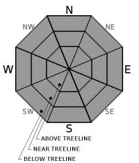
Avalanche Problem 1: Normal Caution
-
Character ?

-
Aspect/Elevation ?
-
Likelihood ?CertainVery LikelyLikelyPossible
 Unlikely
 -
Size ?HistoricVery LargeLargeSmall

Use normal caution today. Generally safe avalanche conditions exist. Watch for unstable snow on isolated terrain features in extreme, steep terrain.
- Isolated slabs are generally related to wind and terrain: look for places where small areas of drifting have occurred and firm layers of surface snow overlie softer layers. Often this will occur on the lee side of ridges, in terrain depressions, on convex terrain features and in the lee of isolated bands of trees.
- Basic avalanche rescue skills are always necessary when you travel in avalanche terrain.
Forecast Discussion
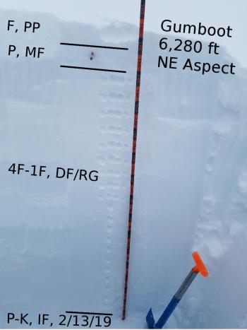
Despite our upside down storm snow structure from earlier this week, the snowpack is rapidly stabilizing and settling out. Snow surface conditions are mixed with lumpy, rain runneled snow below 6,000 feet and smoother surfaces up higher. Variable crusts are likely, some supportable, some not.
The Everitt Memorial Highway is OPEN. Castle Lake road remains closed.
Recent Observations
- Yesterday, column tests indicated weaknesses 9 to 12 inches below the surface, on a layer of lower density snow. Moderate force was required to initiate resistant planar failures. (ECTP18/ECTN15) Increasing stability has been observed over the past two days.
- Winds have averaged 23 mi/hr with gusts to 31 mi/hr out of the west/northwest at 8,000 feet (Gray Butte) Wind transport of snow has been minimal due to heavy, wet nature of recent storm.
- Showery precipitation brought 1 to 2 inches of new snow to terrain above 6,000 feet.
- Recent moist snow layers have frozen and a new crust has formed near the surface of the snowpack
- Deep rain runnels and exposed creeks exist below 5,800 feet on the west side.

Weather and Current Conditions
Weather Summary
A couple weak systems in store for the near future. Mixed sun, snow showers, clouds and cooling temperatures will bring us into the weekend. Snow levels will fall to near 1,000 feet, however accumulation will be minimal. Southwesterly wind will pick up on the mountain tonight and tomorrow. Additional snow showers are expected this weekend.
24 Hour Weather Station Data @ 4:00 AM
| Weather Station | Temp (°F) | Wind (mi/hr) | Snow (in) | Comments | ||||||||
|---|---|---|---|---|---|---|---|---|---|---|---|---|
| Cur | Min | Max | Avg | Avg | Max Gust | Dir | Depth | New | Water Equivalent | Settlement | ||
| Mt. Shasta City (3540 ft) | 36 | 33 | 48 | 39 | 1 | N | ||||||
| Sand Flat (6750 ft) | 18 | 18 | 32 | 25 | 149 | 1 | 0 | 2 | ||||
| Ski Bowl (7600 ft) | 10.5 | 10.5 | 31 | 23 | 182 | 0.5 | 0.1 | 3.5 | ||||
| Gray Butte (8000 ft) | 11.5 | 11.5 | 31 | 23 | 10 | 31 | WNW | |||||
| Castle Lake (5870 ft) | 18 | 18 | 35 | 27 | 145 | 0.5 | 3 | |||||
| Mount Eddy (6509 ft) | 18 | 18 | 27.5 | 21.5 | 1 | 6 | SSE | 142 | 0.5 | 0 | ||
| Ash Creek Bowl (7250 ft) | ||||||||||||
| Ash Creek Ridge (7895 ft) |
Two Day Mountain Weather Forecast
Produced in partnership with the Medford NWS
| For 7000 ft to 9000 ft | |||
|---|---|---|---|
|
Friday (4 a.m. to 10 p.m.) |
Friday Night (10 p.m. to 4 a.m.) |
Saturday (4 a.m. to 10 p.m.) |
|
| Weather | Partly cloudy with a 20% chance of snow showers | Mostly cloudy with a 40% chance of snow showers | Mostly cloudy. Chance of showers in the morning, then show showers likely in the afternoon |
| Temperature (°F) | 26 | 17 | 25 |
| Wind (mi/hr) | Northwest 5 | Southwest 5-10 | South 5-10 |
| Precipitation SWE / Snowfall (in) | / 1-2 | / 1-2 | / 1-3 |
| For 9000 ft to 11000 ft | |||
| Friday | Friday Night | Saturday | |
| Weather | A 20% chance of snow showers, partly cloudy, cold and blustery. | A 50% chance of snow showers, mostly cloudy and windy. | Snow showers likely, mostly cloudy and cold |
| Temperature (°F) | 6 | 4 | 6 |
| Wind (mi/hr) | West 10-15 | Southwest 1-2 | Southwest 20-25 |
| Precipitation SWE / Snowfall (in) | / 1-2 | / 1-2 | / 1-3 |
Season Precipitation for Mount Shasta City
| Period | Measured (in) | Normal (in) | Percent of Normal (%) |
|---|---|---|---|
| From Oct 1, 2025 (the wet season) | 31.49 | 31.23 | 101 |
| Month to Date (since Jul 1, 2026) | 1.96 | 1.73 | 113 |
| Year to Date (since Jan 1, 2026) | 23.08 | 16.02 | 144 |

