

You are here
Avalanche Forecast for 2019-12-14 06:50
- EXPIRED ON December 15, 2019 @ 6:50 amPublished on December 14, 2019 @ 6:50 am
- Issued by Ryan Sorenson - Mount Shasta Avalanche Center
Bottom Line
Avalanche danger is LOW today. LOW avalanche danger does not mean NO avalanche danger. Though recent snow has been moist and little accumulation has been observed, strong to gale force winds could have formed wind slabs in steep isolated terrain above treeline. Natural and human triggered avalanches are unlikely, however not impossible.


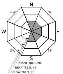
Avalanche Problem 1: Wind Slab
-
Character ?

-
Aspect/Elevation ?
-
Likelihood ?CertainVery LikelyLikelyPossible
 Unlikely
 -
Size ?HistoricVery LargeLargeSmall

Strong to gale force winds were observed near and above treeline on Mount Shasta yesterday. Though fresh snow has been moist in nature keeping snow transport to a minimum, wind slabs could have still form on isolated, easterly aspects. Wind slabs are expected to be small and difficult to trigger today, however use caution if cornices, wind pillows or drifts are encountered.
Other signs of wind slab problems include:
- Shooting cracks, blocking, whumphing
- Convex pillows of wind-drifted snow
- Chalky, hollow sounding snow
Forecast Discussion
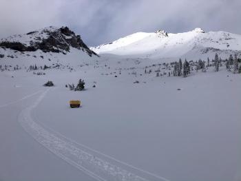
This recent storm felt like a good 'ol Shasta Plaster fest leaving everything covered in rime. Rime occurs when frost forms on cold objects by the rapid freezing of water vapor from low clouds or fog. This leaves snow looking rough and like popcorn or styrofoam. You may encounter rime on snow or any exposed objects above treeline today.
Recent Observations
The recent storm on Mount Shasta was "rimmy and plaster" in nature coating everthing with a thick layer of frozen frost. Low visibility and flat light made observations above treeline difficult. Wind was out of the west, a steady 15-20 mi/hr in exposed areas near treeline and windy in most areas above treeline.
- In the last 24 hours at treeline on Mount Shasta, temperatures have ranged from 16 to 28°F with average wind speeds of 17 mi/hr, gusts to 43 mi/hr out of the west/northwest.
- One to three inches of condensed, moist new snow sits atop a ziper thin rain crust. Total height of snow 47 inches on a SE facing slope near treeline. A variety of crusts exist, some supportable on skis, not boots. Boot penetration 4 - 6 inches. Heavy mist formed a thin zipper crust on top of new snow above treeline.
- Precipitation: Snow/mist like precipitation fell from the sky, the type that rimes up (freezes) on all your clothing, goggles, exposed objects etc. Active riming was observed.
- Sky: cloudy/fog/poor visibility
- No recent avalanche activity or obvious signs of instability
Weather and Current Conditions
Weather Summary
Satellite and radar models show that the recent stormy weather has moved east out of the forecast area early this morning. Expect partly cloudy skies and low temperatures. Temperatures are predicted to be down right cold with highs reaching the mid to low 20s above 7,000 feet and lower teens above 9,000 feet on Mount Shasta today. Winds will die off and shift to northerly throughout the day. There is a slight chance for lingering snow showers to spin back into the area this afternoon. Snow accumulation of around one inch is possible tonight with snow levels near 3,000 feet.
Forecast discussions are calling for another atmospheric river to impact the area late Wednesday or Thursday. We will need to see how this one shapes up over the next couple days before making predictions. Expect more information in coming forecasts.
24 Hour Weather Station Data @ 6:00 AM
| Weather Station | Temp (°F) | Wind (mi/hr) | Snow (in) | Comments | ||||||||
|---|---|---|---|---|---|---|---|---|---|---|---|---|
| Cur | Min | Max | Avg | Avg | Max Gust | Dir | Depth | New | Water Equivalent | Settlement | ||
| Mt. Shasta City (3540 ft) | 39 | 29 | 43 | 36 | 2 | N | ||||||
| Sand Flat (6750 ft) | 22 | 22 | 33 | 31 | 31 | n/a | 0 | 0 | Station not recording snow depth | |||
| Ski Bowl (7600 ft) | 17 | 17 | 29.5 | 26.5 | 42 | 2.5 | 0.24 | 1 | ||||
| Gray Butte (8000 ft) | 16.5 | 16.5 | 28.5 | 25.5 | 17 | 43 | W | |||||
| Castle Lake (5870 ft) | 0 | 0 | 0 | 0 | 0 | 0 | 0 | down | ||||
| Mount Eddy (6509 ft) | 22.5 | 22.5 | 34 | 30 | 1 | 8 | S | 29.3 | n/a | 0 | ||
| Ash Creek Bowl (7250 ft) | down | |||||||||||
| Ash Creek Ridge (7895 ft) | down |
Two Day Mountain Weather Forecast
Produced in partnership with the Medford NWS
| For 7000 ft to 9000 ft | |||
|---|---|---|---|
|
Saturday (4 a.m. to 10 p.m.) |
Saturday Night (10 p.m. to 4 a.m.) |
Sunday (4 a.m. to 10 p.m.) |
|
| Weather | Partly cloudy then mostly cloudy. Chance of precipitation is 50%. Snow levels near town. | Mostly cloudy, snow showers likely in the evening. Chance of precipitation is 70%. Snow levels near town. | Mostly cloudy then clearing. |
| Temperature (°F) | 30 and falling | 23 | 26 |
| Wind (mi/hr) | Northwest 5-10 | Northwest 0-5 | North 0-5 |
| Precipitation SWE / Snowfall (in) | 0.02 / 0-1 | 0.04 / 0-1 | 0.00 / 0 |
| For 9000 ft to 11000 ft | |||
| Saturday | Saturday Night | Sunday | |
| Weather | Partly cloudy then mostly cloudy. Chance of precipitation is 50%. Snow levels near town. | Mostly cloudy, snow showers likely in the evening. Chance of precipitation is 70%. Snow levels near town. | Mostly cloudy then clearing. |
| Temperature (°F) | 14 | 10 | 14 |
| Wind (mi/hr) | Northwest 15-20 | Northwest 10-15 | Northwest 10-15 |
| Precipitation SWE / Snowfall (in) | 0.02 / 0-1 | 0.04 / 0-1 | 0.00 / 0 |
Season Precipitation for Mount Shasta City
| Period | Measured (in) | Normal (in) | Percent of Normal (%) |
|---|---|---|---|
| From Oct 1, 2025 (the wet season) | 8.03 | 10.43 | 77 |
| Month to Date (since Jun 1, 2026) | 5.35 | 3.07 | 174 |
| Year to Date (since Jan 1, 2026) | 45.77 | 38.43 | 119 |

