

You are here
Avalanche Forecast for 2019-12-15 06:30
- EXPIRED ON December 16, 2019 @ 6:30 amPublished on December 15, 2019 @ 6:30 am
- Issued by Ryan Sorenson - Mount Shasta Avalanche Center
Bottom Line
Avalanche danger is LOW today. While unlikely, lingering wind slabs could remain on isolated, leeward terrain. Natural and human triggered avalanches are unlikely, however not impossible. Normal caution is advised.


Avalanche Problem 1: Normal Caution
-
Character ?

-
Likelihood ?CertainVery LikelyLikelyPossible
 Unlikely
 -
Size ?HistoricVery LargeLargeSmall

An inch of new snow yesterday and last night with light northwest wind could have created small, thin isolated wind slabs on leeward aspects. Wind slabs are expected to remain inconsequential in size and difficult to trigger today.
Exercise normal caution when traveling in the backcountry. This means:
- Always watch for isolated slabs on leeward terrain.
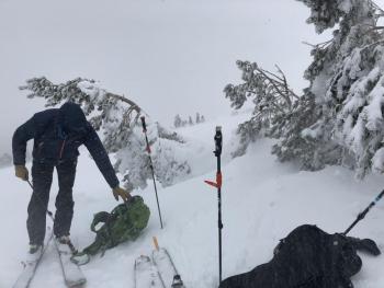
- Continue to carry rescue gear and know how to use it. Mandatory rescue gear includes: avalanche beacon, shovel, and probe.
- Basic avalanche rescue skills are always essential when you travel in avalanche terrain.
Forecast Discussion
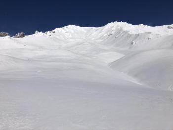
The wind over the last few days has pressed and sculpted much of the snowpack near and above treeline. Use caution as many rocks and hazards have reemerged as obstacles.
Recent Observations
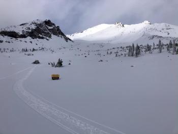
Clear skies yesterday morning brought many folks to Mount Shasta to enjoy the snow. A wide variety of snow hardness and surface textures exists. In protected areas below treeline soft new snow over a variety of crusts can be found. On near and above treeline terrain wind effected snow is more common. Sustained westerly and northerly winds of 16 to 28 mi/hr and gusts to 43 mi/hr were recorded at our Gray Butte weather station for 20 hours of the last 24 hours (8 am 12/13 to 4 am 12/14). This has transformed and sculpted much of the snow available for transport near and above treeline. Average snow depth was 5 feet 7 inches at 9,300 feet on a south west aspect of Old Ski Bowl. A pit dug found 1 finger hard wind packed snow over a variety of crusts. For more information see observation below. No signs of instabilities have been observed.
Temperatures maxed out at 23 at 8,000 feet yesterday afternoon. It began to lightly snow (S-1) around 2 pm with snow levels near 3,000 feet. Accumulation of 1 inch over that last 24 hours has been recorded at our Old Ski Bowl weather station 7,500 feet.
Weather and Current Conditions
Weather Summary
There is a slight chance of some lingering snow flurries early this morning then drier sunny conditions will prevail for the next few days. Temperature will remain in the mid 20s to lower 30s through Wednesday. The wind is expected to remain relatively mild throughout this time as well, though upper elevations will have some moderate wind early this morning as the storm continues to exit to the east.
A large shift in weather is predicted to arrive late Wednesday night. Models are showing that a storm is building and strengthening in the pacific setting the stage for a strong atmospheric river event. Snow levels should remain around 5,000 to 6,000 feet as 2 to 4 inches of water precipitates out through the weekend.
24 Hour Weather Station Data @ 6:00 AM
| Weather Station | Temp (°F) | Wind (mi/hr) | Snow (in) | Comments | ||||||||
|---|---|---|---|---|---|---|---|---|---|---|---|---|
| Cur | Min | Max | Avg | Avg | Max Gust | Dir | Depth | New | Water Equivalent | Settlement | ||
| Mt. Shasta City (3540 ft) | 28 | 28 | 42 | 33 | 1 | N | ||||||
| Sand Flat (6750 ft) | 20 | 15 | 29 | 22 | 33.3 | 1 | 0 | 0 | ||||
| Ski Bowl (7600 ft) | 18.5 | 13.5 | 24.5 | 18 | 42.5 | 1 | 0.06 | 0 | ||||
| Gray Butte (8000 ft) | 14.5 | 14.5 | 23.5 | 17.5 | 6 | 25 | W | |||||
| Castle Lake (5870 ft) | 0 | 0 | 0 | 0 | 0 | 0 | 0 | down | ||||
| Mount Eddy (6509 ft) | 20.5 | 13.5 | 28 | 21 | 1 | 7 | SW | 34 | 1 | 0 | ||
| Ash Creek Bowl (7250 ft) | down | |||||||||||
| Ash Creek Ridge (7895 ft) | down |
Two Day Mountain Weather Forecast
Produced in partnership with the Medford NWS
| For 7000 ft to 9000 ft | |||
|---|---|---|---|
|
Sunday (4 a.m. to 10 p.m.) |
Sunday Night (10 p.m. to 4 a.m.) |
Monday (4 a.m. to 10 p.m.) |
|
| Weather | Partly cloudy becoming sunny a slight chance of snow showers before 10 am. Chance of precipitation is 20%. | Mostly clear becoming partly cloudy | Partly cloudy becoming sunny |
| Temperature (°F) | 26 | 22 | 26 |
| Wind (mi/hr) | Northwest 5-10 | North 5-10 | East 0-5 |
| Precipitation SWE / Snowfall (in) | 0.02 / 0-0.50 | 0.00 / 0 | 0.00 / 0 |
| For 9000 ft to 11000 ft | |||
| Sunday | Sunday Night | Monday | |
| Weather | Becoming sunny a slight chance of snow showers before 10 am. Chance of precipitation is 20%. | Mostly clear becoming partly cloudy | Partly cloudy becoming sunny |
| Temperature (°F) | 14 | 14 | 14 |
| Wind (mi/hr) | Northwest 20-25 | Northwest 20-25 | Northeast 10-15 |
| Precipitation SWE / Snowfall (in) | 0.02 / 0-0.50 | 0.00 / 0-1 | 0.00 / 0 |
Season Precipitation for Mount Shasta City
| Period | Measured (in) | Normal (in) | Percent of Normal (%) |
|---|---|---|---|
| From Oct 1, 2025 (the wet season) | 8.04 | 10.68 | 75 |
| Month to Date (since Jun 1, 2026) | 5.36 | 3.32 | 161 |
| Year to Date (since Jan 1, 2026) | 45.78 | 38.68 | 118 |

