

You are here
Avalanche Forecast for 2019-12-16 06:45
- EXPIRED ON December 17, 2019 @ 6:45 amPublished on December 16, 2019 @ 6:45 am
- Issued by Ryan Sorenson - Mount Shasta Avalanche Center
Bottom Line
Avalanche danger is LOW. LOW avalanche danger does not mean NO avalanche danger. Natural and human triggered avalanches are unlikely, however not impossible. Exercise normal caution.


Avalanche Problem 1: Normal Caution
-
Character ?

-
Likelihood ?CertainVery LikelyLikelyPossible
 Unlikely
 -
Size ?HistoricVery LargeLargeSmall

While unlikely, lingering wind slabs could remain on isolated, leeward terrain. Wind slabs are expected to remain inconsequential in size today but might throw an unaware skier off balance if the slabs are sitting atop firmer snow.
Exercise normal caution when traveling in the backcountry. This means:
- Evaluate the snowpack if traveling in or near steep terrain.
- Always watch for isolated slabs on leeward terrain.
- Continue to carry rescue gear and know how to use it. Mandatory rescue gear includes: avalanche beacon, shovel, and probe.
- Basic avalanche rescue skills are always essential when you travel in avalanche terrain.
Recent Observations
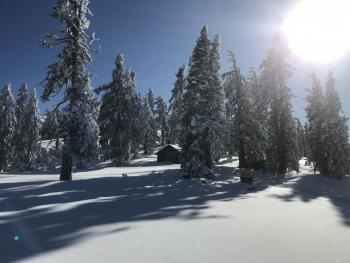
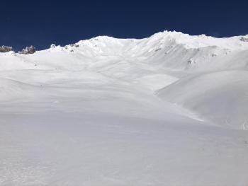
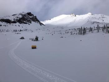
In the last 24 hours at the Old Ski Bowl, temperatures have ranged from 12 to 26°F. There were low lying scattered clouds with a ceiling around 7,000 feet throughout the day on Mount Shasta. For a brief period after noon this ceiling rose creating fogy white out conditions above treeline. The wind was out of the southwest for most of the morning then switched to easterly mid afternoon. Loose blowing snow was encountered above treeline but little to no loading was observed.
Soft snow can still be found in the trees, on proteced faces, and shady areas near and below treeline. Gullies seemed to host the best snow above treeline, but varible is the best word to describe it. Chickenheads, rime, and sastrugi cover the exposed ridgelines and moraines. Ski and boot penitrations varied from less than 1 inch on wind packed areas above treeline and 4 to 6 inches in the trees and on protected faces near and below treeline. Very small, 1 to 2 feet deep, wind slabs were encountered in the lee of trees and easterly ridge tops. There are still a few rocks and hazards lurking just below the snow surface.
Weather and Current Conditions
Weather Summary
Count on sunny bright conditions today. Temperature will max out in the lower 30s on Mount Shasta. The wind has shifted to easterly and will remain light with gusty conditions for upper elevations.
Stormy weather is predicted to arrive late Wednesday night. Though recent models are showing that the greatest impacts will be felt north of the forecast area, we will have significant snowfall through the weekend. Snow levels should remain around 5,000 to 6,000 feet and upwards of two feet of snow is possible.
24 Hour Weather Station Data @ 6:00 AM
| Weather Station | Temp (°F) | Wind (mi/hr) | Snow (in) | Comments | ||||||||
|---|---|---|---|---|---|---|---|---|---|---|---|---|
| Cur | Min | Max | Avg | Avg | Max Gust | Dir | Depth | New | Water Equivalent | Settlement | ||
| Mt. Shasta City (3540 ft) | 23 | 22 | 41 | 30 | 2 | N | ||||||
| Sand Flat (6750 ft) | 14 | 13 | 27 | 19 | 33 | 0 | 0 | .5 | ||||
| Ski Bowl (7600 ft) | 18 | 12.5 | 26 | 18 | 40.6 | 0 | 0 | 2 | ||||
| Gray Butte (8000 ft) | 22 | 14.5 | 25 | 18.5 | 4 | 12 | E | |||||
| Castle Lake (5870 ft) | 0 | 0 | 0 | 0 | 0 | 0 | 0 | down | ||||
| Mount Eddy (6509 ft) | 21.5 | 14 | 26 | 20 | 2 | 7 | WSW | 32 | 0 | 2 | ||
| Ash Creek Bowl (7250 ft) | down | |||||||||||
| Ash Creek Ridge (7895 ft) | down |
Two Day Mountain Weather Forecast
Produced in partnership with the Medford NWS
| For 7000 ft to 9000 ft | |||
|---|---|---|---|
|
Monday (4 a.m. to 10 p.m.) |
Monday Night (10 p.m. to 4 a.m.) |
Tuesday (4 a.m. to 10 p.m.) |
|
| Weather | Sunny | Clear | Mostly cloudy |
| Temperature (°F) | 31 | 25 | 31 |
| Wind (mi/hr) | East 0-5 | East 5-10 | Southeast 5-10 |
| Precipitation SWE / Snowfall (in) | 0.02 / 0-0.50 | 0.00 / 0 | 0.00 / 0 |
| For 9000 ft to 11000 ft | |||
| Monday | Monday Night | Tuesday | |
| Weather | Sunny | Clear | Mostly cloudy |
| Temperature (°F) | 24 | 24 | 25 |
| Wind (mi/hr) | Northeast 10-15 | Southeast 10-15 | South 25-30 |
| Precipitation SWE / Snowfall (in) | 0.02 / 0 | 0.00 / 0 | 0.00 / 0 |
Season Precipitation for Mount Shasta City
| Period | Measured (in) | Normal (in) | Percent of Normal (%) |
|---|---|---|---|
| From Oct 1, 2025 (the wet season) | 8.04 | 10.94 | 73 |
| Month to Date (since Jul 1, 2026) | 5.36 | 3.58 | 150 |
| Year to Date (since Jan 1, 2026) | 45.78 | 38.94 | 118 |

