

You are here
Avalanche Forecast for 2019-12-18 07:00
- EXPIRED ON December 19, 2019 @ 7:00 amPublished on December 18, 2019 @ 7:00 am
- Issued by Aaron Beverly - Mount Shasta Avalanche Center
Bottom Line
Avalanche danger will rise to MODERATE late tonight as southwest winds combine with up to 5-7 inches of new snow to form wind slabs. Avoid leeward terrain greater than 35 degrees near and above treeline. An atmospheric river event will be affecting the forecast area tonight through Sunday morning.


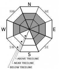
Avalanche Problem 1: Wind Slab
-
Character ?

-
Aspect/Elevation ?
-
Likelihood ?CertainVery LikelyLikelyPossible
 Unlikely
 -
Size ?HistoricVery LargeLargeSmall

Avalanche Danger will rise late tonight as moderate to strong southwest winds combine with up to 5-7 inches of new snow to form wind slabs. These slabs could sit atop weak layers and smooth bed surfaces.
Pay attention to the wind. Where is it blowing snow? Look for wind slabs on leeward aspects. Shooting cracks, blocking, and wind drifts are all signs that winds slabs are forming. Look for these signs while traveling in safe terrain.
Forecast Discussion
The incoming storm will trend from cold to warm. This will produce an upside down configuration with new incoming snow. Tonight's temperatures will be remain cold, though, so this configuration will probably not been seen until later in the day tomorrow.
Some elevations have a widespread, thin layer of unbounded, granular snow. This sits atop a thick block of icy snow. This will definitely be of concern as new snow is deposited on top. Slab + weak layer + bed surface = perfect recipe for an avalanche.
Recent Observations
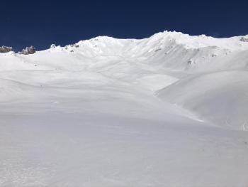
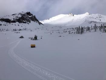
Overall, the snowpack on Mount Shasta and in the Eddies is stable at all elevations. Though some snow is still being transported by winds, no concerning wind slab problems have been encountered. No signs of instability have been seen.
Above treeline surface snow is variable: firm and icy, wind affected, rimed, chalky, and breakable.
Near and below treeline still hosts low density snow in north facing, shady, wind protected areas. A thin layer of unbounded granular snow was widespread near and below treeline around Cliff Lake yesterday. Surface hoar has been encountered in exposed areas.
Weather and Current Conditions
Weather Summary
Over the next 24 hours, mostly after 4 p.m., expect up to 5 inches of snow near town (City of Mount Shasta) and up to 7 inches at higher elevations. This will be accompanied by moderate to strong southwest winds.
The four day atmospheric river event approaching the west coast is looking a bit more optimistic than previously reported. You can interpret "optimistic" to be more precipitation. By Sunday, close to 3 inches of precipitable water is expected. Elevations where this falls as snow will vary throughout the event.
The first sizable wave of precipitation will be tonight and tomorrow. Snow levels will start out near town tonight. Tomorrow they will rise to 5,000 ft.
The next wave will come Saturday morning with snow levels expected to be 4,500 to 5,500 ft.
24 Hour Weather Station Data @ 6:00 AM
| Weather Station | Temp (°F) | Wind (mi/hr) | Snow (in) | Comments | ||||||||
|---|---|---|---|---|---|---|---|---|---|---|---|---|
| Cur | Min | Max | Avg | Avg | Max Gust | Dir | Depth | New | Water Equivalent | Settlement | ||
| Mt. Shasta City (3540 ft) | 35 | 31 | 41 | 34.5 | 0 | N | ||||||
| Sand Flat (6750 ft) | 23 | 23 | 29 | 27 | 33 | 0 | 0 | 0 | ||||
| Ski Bowl (7600 ft) | 20 | 20 | 31 | 25 | 39.6 | 0 | 0 | 0 | ||||
| Gray Butte (8000 ft) | 18 | 18 | 24 | 22 | 11 | 31 | SE | |||||
| Castle Lake (5870 ft) | down | |||||||||||
| Mount Eddy (6509 ft) | 22.5 | 22.5 | 29 | 25.5 | 2 | 13 | S | 31.7 | 0 | 0 | ||
| Ash Creek Bowl (7250 ft) | down | |||||||||||
| Ash Creek Ridge (7895 ft) | down |
Two Day Mountain Weather Forecast
Produced in partnership with the Medford NWS
| For 7000 ft to 9000 ft | |||
|---|---|---|---|
|
Wednesday (4 a.m. to 10 p.m.) |
Wednesday Night (10 p.m. to 4 a.m.) |
Thursday (4 a.m. to 10 p.m.) |
|
| Weather | Mostly cloudy. Chance of snow is 60% after 4 p.m. | Snow. Chance of precipitation is 100%. | Snow. Breezy and gusty. Chance of precipitation is 100%. |
| Temperature (°F) | 24 | 28 | 33 |
| Wind (mi/hr) | Southwest 15-20 | South 10-15 | South 10-15 |
| Precipitation SWE / Snowfall (in) | 0.06 / 0-1 | 0.35 / 2-4 | 0.25 / 1-2 |
| For 9000 ft to 11000 ft | |||
| Wednesday | Wednesday Night | Thursday | |
| Weather | Mostly cloudy. Windy and gusty. Low wind chills. Chance of precipitation is 60% after 4 p.m. | Snow. Windy and gusty. Low wind chills. Chance of precipitation is 90%. | Snow. Windy and gusty. Low wind chills. Chance of precipitation is 100%. |
| Temperature (°F) | 18 | 13 | 19 |
| Wind (mi/hr) | Southwest 25-30 | West 30-40 | Southwest 30-40 |
| Precipitation SWE / Snowfall (in) | 0.06 / 0-2 | 0.35 / 3-5 | 0.25 / 1-3 |
Season Precipitation for Mount Shasta City
| Period | Measured (in) | Normal (in) | Percent of Normal (%) |
|---|---|---|---|
| From Oct 1, 2025 (the wet season) | 8.04 | 11.48 | 70 |
| Month to Date (since Jul 1, 2026) | 5.36 | 4.12 | 130 |
| Year to Date (since Jan 1, 2026) | 45.78 | 39.48 | 116 |

