

You are here
Avalanche Forecast for 2019-12-20 05:37
- EXPIRED ON December 21, 2019 @ 5:37 amPublished on December 20, 2019 @ 5:37 am
- Issued by Nick Meyers - Shasta-Trinity National Forest
Bottom Line
Up to 13 inches of fresh snow combined with incessant W/SW wind has formed wind slabs on NE-E-SE aspects. Expect MODERATE avalanche danger today. Human triggered avalanches are possible on steep, leeward terrain near and above treeline. Whole Gale wind speeds will be attained over the next 24 hours in exposed terrain.


Avalanche Problem 1: Wind Slab
-
Character ?

-
Aspect/Elevation ?
-
Likelihood ?CertainVery LikelyLikelyPossible
 Unlikely
 -
Size ?HistoricVery LargeLargeSmall

West/Southwest wind combined with up to 13 inches of fresh snow has drifted significant amounts of snow in near and above treeline terrain. Wind slabs 1 -2 feet deep exist on primarily NE-E-SE aspects. Expected avalanche size is up to D2. Wind out of the W/SW will continue today. Avoid steep, leeward terrain near ridgelines, tops of bowls, near rocky outcrops and/or extreme terrain.
Shooting cracks, blocking, cornices, wind drifts or hard/scoured snow that suddenly transitions to soft snow are all signs that winds slabs may be near. Use small test slopes to check how drifts may react to the weight of a person or sled.
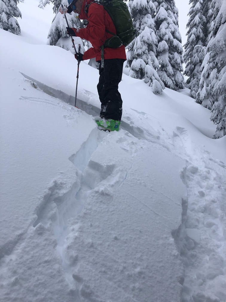
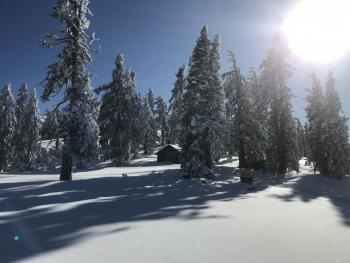
Photo: East of Mount Shasta in the Ash Creek Butte area, blocking near switchback of skin track up a NE aspect.
Forecast Discussion
Remember, WIND can transport snow and load a slope 10x faster than snow falling from the sky. Pay attention out there!
This video illustrates the ins-and-outs of the North American Avalanche Danger Scale. Have a look...
Recent Observations
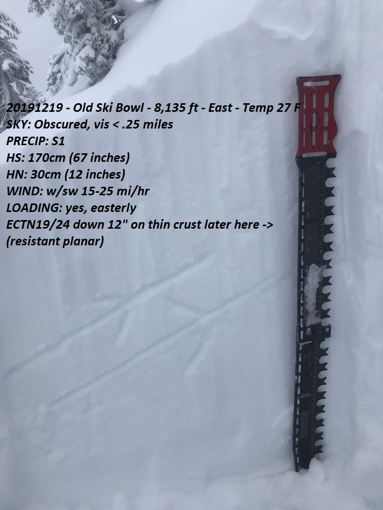
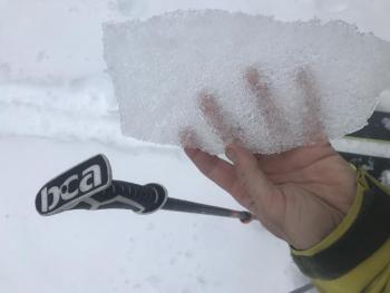
Significant amounts of blowing and drifting snow was observed near and above treeline in the Old Ski Bowl yesterday. Numerous stability tests produced resistant planar failures 1 foot deep near a thin crust with moderate force. Visibility was very poor. Lesser amounts of blowing snow were reported from the Horse Camp and Giddy Giddy Gulch area. East of Mount Shasta in the Ash Creek Butte area, windy conditions were observed with cracking and blocking along a skin track on a leeward, NE aspect.
- West/Southwest wind has averaged 12 mph with gusts to 31 mph over the past 3 days, recorded at 8,000 feet on Gray Butte.
- Temps have averaged 25 deg F with a max of 31 deg F and min of 17 deg F
- Drifts on NE-E-SE aspects 1 - 2 feet deep
- New snow totals 10 - 13 inches
- Total Height of Snow at treeline: 48 inches
Weather and Current Conditions
Weather Summary
The atmospheric river affecting the forecast area has shifted to the north this morning and thus, a break in precipitation...but not wind. You guessed it -- west/southwest wind will increase today/tonight. Expect 50+ mph wind in exposed areas in the mountains. Additional precipitation will arrive at the coast tonight and spread inland Saturday. Snow levels with Saturday's kicker should linger around 5,400 feet, dropping to 4,000 feet by Sunday as colder air elbows it's way in.
24 Hour Weather Station Data @ 4:00 AM
| Weather Station | Temp (°F) | Wind (mi/hr) | Snow (in) | Comments | ||||||||
|---|---|---|---|---|---|---|---|---|---|---|---|---|
| Cur | Min | Max | Avg | Avg | Max Gust | Dir | Depth | New | Water Equivalent | Settlement | ||
| Mt. Shasta City (3540 ft) | 42 | 36 | 42 | 40 | 6 | E | ||||||
| Sand Flat (6750 ft) | 33 | 27 | 33 | 31 | 35 | 2 | 0 | 1 | ||||
| Ski Bowl (7600 ft) | 30 | 23 | 30 | 27 | 48 | 5.3 | 0.55 | 2.1 | ||||
| Gray Butte (8000 ft) | 29 | 22 | 29.5 | 26 | 14 | 31 | W | |||||
| Castle Lake (5870 ft) | 0 | 0 | 0 | 0 | 0 | 0 | 0 | down | ||||
| Mount Eddy (6509 ft) | 32.5 | 27 | 33 | 30 | 2 | 11 | SSE | 33 | 1.2 | 1 | ||
| Ash Creek Bowl (7250 ft) | down | |||||||||||
| Ash Creek Ridge (7895 ft) | down |
Two Day Mountain Weather Forecast
Produced in partnership with the Medford NWS
| For 7000 ft to 9000 ft | |||
|---|---|---|---|
|
Friday (4 a.m. to 10 p.m.) |
Friday Night (10 p.m. to 4 a.m.) |
Saturday (4 a.m. to 10 p.m.) |
|
| Weather | Windy, mostly cloudy with a 50% chance of rain and snow, snow level near 6,600 feet. | Very windy, mostly cloudy with a chance of rain and snow. Chance of precipitation 20%. Snow levels near 6,400 feet. | Windy, mostly cloudy with a 40% chance of rain and snow |
| Temperature (°F) | 33 | 32 | 31 |
| Wind (mi/hr) | South 20-25 | South 20-25 | South 20-25 |
| Precipitation SWE / Snowfall (in) | 0.11 / 1-3 | 0.00 / 0 | 0.37 / 1-3 |
| For 9000 ft to 11000 ft | |||
| Friday | Friday Night | Saturday | |
| Weather | Windy, mostly cloudy with a 40% chance of snow. | Windy, mostly cloudy with a 20% chance of snow. | Snow, mainly after 4pm. Windy. Chance of precipitation 80%. |
| Temperature (°F) | 29 | 27 | 23 |
| Wind (mi/hr) | West/Southwest 35-45 | West/Southwest 45-55 | Southwest 55-65 |
| Precipitation SWE / Snowfall (in) | 0.11 / 2-4 | 0.00 / 0 | 0.37 / 2-4 |
Season Precipitation for Mount Shasta City
| Period | Measured (in) | Normal (in) | Percent of Normal (%) |
|---|---|---|---|
| From Oct 1, 2025 (the wet season) | 8.13 | 12.04 | 68 |
| Month to Date (since Jun 1, 2026) | 5.45 | 4.68 | 116 |
| Year to Date (since Jan 1, 2026) | 45.87 | 40.04 | 115 |

