

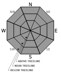
You are here
Avalanche Forecast for 2019-12-21 05:43
- EXPIRED ON December 22, 2019 @ 5:43 amPublished on December 21, 2019 @ 5:43 am
- Issued by Nick Meyers - Shasta-Trinity National Forest
Bottom Line
The ice capped snowpack has sealed off any current avalanche concerns and LOW danger will exist for daylight hours. Extremely icy conditions exist near and above treeline. A slide for life is likely should one slip and fall.
All focus is for tonight and tomorrow. A winter storm warning is in effect from 4pm this afternoon to 4pm Sunday, above 4,000 feet. Uncertainty remains regarding how well the new snow will bond to the smooth, hard, widespread ice layer.


Avalanche Problem 1: Normal Caution
-
Character ?

-
Aspect/Elevation ?
-
Likelihood ?CertainVery LikelyLikelyPossible
 Unlikely
 -
Size ?HistoricVery LargeLargeSmall

A different kind of caution is necessary today. You won't see any type of slabs cracking, but you might see cracks in the ice layer that has effectively sealed off this weeks fresh snow!
- Higher, wind exposed terrain is likely very firm, extremely icy and super dangerous. A slip and fall would send you the distance.
- Skiing, if you'd call it that, won't be for the faint of heart. Bring your survival techniques.
LOW avalanche danger exists for the time being. All eyes are pinned on the incoming storm. Uncertainty exists as to how well the new snow will bond to the ice capped snowpack. A significant snow load (wind slab or storm slab) could fail below or above the ice layer. Fist hard, new snow exists below the ice. Where the ice lens is thin at lower elevations, a significant snow load could cause failure below. Where the ice lens is thicker and more supportable at higher elevations, a significant snow load night fail on top. We simply are not sure and it will all depend on temperatures and how much snow we receive from the storm on deck. Unique conditions can result in unique avalanches. Use caution over the next couple days.
Forecast Discussion
Be careful out there. The ice capped snowpack is no joke. If you feel like practicing your survival skiing, now is the time.
Not all avalanches are made the same. As a result, travel and decisions in avalanche terrain are influenced by the kind of avalanche you expect to encounter.
Recent Observations
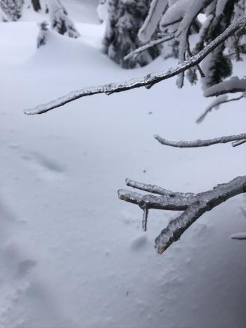
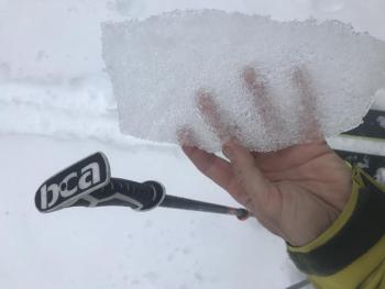
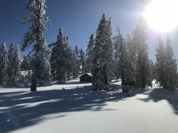
As sliders and riders went to bed on the evening of December 19th, a foot of fresh powder danced in their heads. Little did they realize, a rapid warming took place that evening and paired up with freezing fog and rain. Just like you'd hot sear that tuna steak you wished you caught, a widespread .5 to 1 cm ice crust effectively capped off the snowpack by the morning of December 20th. Click here for observation with photos and video. This ice layer was observed from approximately 6,500 feet and existed to the top of Gray Butte, 8,000 feet. The higher in elevation, the thicker the crust. Below 6,500 feet, the ice lens disappeared and rain runnels dominate. Higher on the mountain in wind scoured terrain, it's likely to be extremely icy and very dangerous, slide for life conditions.
- No snow currently available for wind transport due to ice capped snowpack
- South/Southwest wind has averaged 15-20 mph in the past 24 hours with a max gust of 49 mph
- Temperatures at treeline: 24 hour Max-31 deg F / Min: 26 deg F
- New snow: 0
- Height of snow (treeline on Mt Shasta): 46"
Weather and Current Conditions
Weather Summary
A winter storm warning has been issued by the NWS Medford, in effect from 4pm this afternoon to 4pm PST Sunday above 4,000 feet. The tail of the tiger will close in on the forecast area this afternoon into tonight. Precipitation has already started at the coast. For most of today, strong south wind, especially in higher terrain, is expected. Tonight through Sunday, about an inch of snow water equivalent is forecast. Snow levels will hover near 5,500 feet today, though a cooling trend will bring it down to 4,800 feet tonight and 3,900 feet tomorrow. Precipitation will gradually wind down Sunday night. Perhaps up to a foot of fresh snow is possible above 7,000 feet by close of (weekend) business!
24 Hour Weather Station Data @ 0500
| Weather Station | Temp (°F) | Wind (mi/hr) | Snow (in) | Comments | ||||||||
|---|---|---|---|---|---|---|---|---|---|---|---|---|
| Cur | Min | Max | Avg | Avg | Max Gust | Dir | Depth | New | Water Equivalent | Settlement | ||
| Mt. Shasta City (3540 ft) | 41 | 39 | 43 | SW | ||||||||
| Sand Flat (6750 ft) | 31 | 31 | 33 | 33 | ||||||||
| Ski Bowl (7600 ft) | 26 | 26 | 31 | 46 | 0 | .02 | 2 | |||||
| Gray Butte (8000 ft) | 25 | 25 | 29 | 49 | S | |||||||
| Castle Lake (5870 ft) | down | |||||||||||
| Mount Eddy (6509 ft) | 31 | 31 | 32 | 15 | SW | 31 | 0 | 1 | ||||
| Ash Creek Bowl (7250 ft) | down | |||||||||||
| Ash Creek Ridge (7895 ft) | down |
Two Day Mountain Weather Forecast
Produced in partnership with the Medford NWS
| For 7000 ft to 9000 ft | |||
|---|---|---|---|
|
Saturday (4 a.m. to 10 p.m.) |
Saturday Night (10 p.m. to 4 a.m.) |
Sunday (4 a.m. to 10 p.m.) |
|
| Weather | A 30 percent chance of snow after 10am. Mostly cloudy, windy. Total daytime snow accumulation of less than one inch. Snow levels near 5,500 feet. | Snow likely. Mostly cloudy, windy. Chance of precipitation is 70%. New snow accumulation of 3 to 5 inches possible. Snow levels near 4,800 feet | Snow. Temperature falling to around 26 by 4pm. Windy. Chance of precipitation is 100%. New snow accumulation of 5 to 9 inches possible. Snow levels near 3,900 feet |
| Temperature (°F) | 34 | 31 | 30 and falling |
| Wind (mi/hr) | South 20-30 | South 20-30 | South 10-20 |
| Precipitation SWE / Snowfall (in) | 0.16 / 0-1 | 0.05 / 3-5 | 0.78 / 5-9 |
| For 9000 ft to 11000 ft | |||
| Saturday | Saturday Night | Sunday | |
| Weather | A 30 percent chance of snow, mainly after 4pm. Mostly cloudy. Windy. Wind chill values as low as -11. Total daytime snow accumulation of around an inch possible. | Snow likely, mainly after 10pm. Mostly cloudy. Windy. Wind chill values as low as -11. Chance of precipitation is 60%. New snow accumulation of 3 to 7 inches possible. | Snow. Windy. Wind chill values as low as -14. Chance of precipitation is 100%. New snow accumulation of 6 to 10 inches possible. |
| Temperature (°F) | 25 falling | 19 | 16 falling |
| Wind (mi/hr) | South 60-70 | South 60-70 | Southwest 50-60 |
| Precipitation SWE / Snowfall (in) | 0.16 / 0-1 | 0.05 / 3-7 | 0.78 / 6-10 |
Season Precipitation for Mount Shasta City
| Period | Measured (in) | Normal (in) | Percent of Normal (%) |
|---|---|---|---|
| From Oct 1, 2025 (the wet season) | 8.25 | 12.32 | 67 |
| Month to Date (since Jun 1, 2026) | 5.57 | 4.96 | 112 |
| Year to Date (since Jan 1, 2026) | 45.99 | 40.32 | 114 |

