

You are here
Avalanche Forecast for 2019-12-22 07:00
- EXPIRED ON December 23, 2019 @ 7:00 amPublished on December 22, 2019 @ 7:00 am
- Issued by Ryan Sorenson - Mount Shasta Avalanche Center
Bottom Line
Avalanche danger will rise today as 4 to 8 inches of snow and strong southerly winds load an extremely icy snowpack. Uncertainty remains regarding the bonding of new snow to the ice capped snowpack. Evaluate snow and terrain carefully. In addition to possible avalanche danger, very dangerous slide for life conditions are likely should one slip and fall.


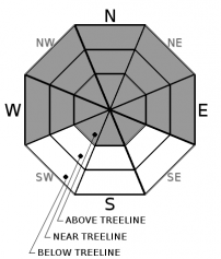
Avalanche Problem 1: Wind Slab
-
Character ?

-
Aspect/Elevation ?
-
Likelihood ?CertainVery LikelyLikelyPossible
 Unlikely
 -
Size ?HistoricVery LargeLargeSmall

New snow will fall today as strong south wind continues to blow. The wind will drift new snow into firm slabs over an icy bed surface. Wind slabs could be touchy and easily triggered. Use caution and identify features of concern. Avoid steep wind loaded slopes. Fresh cornices, blowing snow, snow drifts and uneven snow surfaces are all signs that wind slabs are nearby.
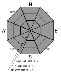
Avalanche Problem 2: Storm Slab
-
Character ?

-
Aspect/Elevation ?
-
Likelihood ?CertainVery LikelyLikelyPossible
Unlikely
Heavy snow fall is predicted to occur around midday today. We could see upwards of 8 inches of new storm snow accumulate by late this afternoon. Uncertainty remains as this new snowfall will load a complex and icy snowpack. Above and near treeline an icy bed surface is ideal for avalanches to slide on. Below treeline, avalanches could occur within the existing snowpack if an instability were to fail below the crust layer. Use caution and evaluate snow and terrain carefully.
Forecast Discussion
It would be wise to bring a helmet today. Extremely icy conditions under the new snow is unpredictable. Strong gusty winds could knock tree limbs down on unsuspecting backcountry users.
Much uncertainty remains due to a wide spread ice lens. Evaluate the snow and terrain carefully. There is likely to be extremely icy and very dangerous, slide for life conditions in some areas. In other areas heightened avalanche conditions exist.
Recent Observations
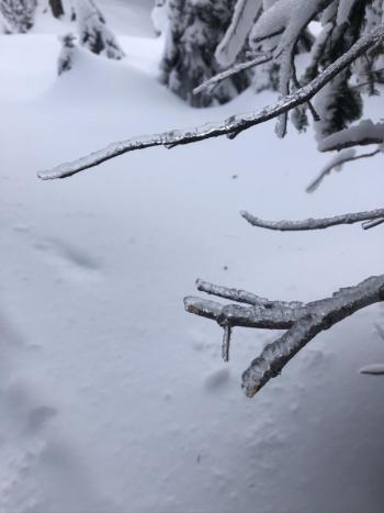
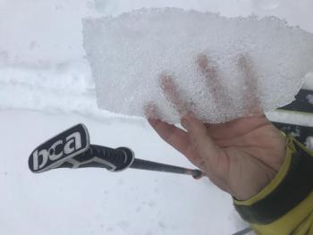
There is a widespread ice lens that has made any snow travel difficult. It is extremely ICY out there! This ice lens occurred on the evening of December 19th, when rapid warming paired with freezing fog and rain capped off the previously powdery snowpack. This ice lens dominates the snowpack and as been observed from 6,500 feet to 8,000 at the top of Gray Butte and 7,000 to 8,300 feet in Avalanche Gulch (see observations below). The ice lens is impressively thick at higher elevations. At lower elevations the crust gets thinner and easily breakable. It disappears altogether below 6,500 feet. Much uncertainty remains how this will hold future snow loads.
- Little to no snow is currently available for wind transport due to an ice capped snowpack
- Very strong southern winds and gale force gusts have scattered branches and knocked ice chunks from trees.
- South/Southwest wind has maxed out at 23 mi/hr with gust as high as 42 mi/hr in the last 24 hours on Gray Butte 8,000 feet.
- Temperatures near treeline: 24 hour maximum: 26 degrees F; 24 hour minimum: 24 degrees F
- New snow: 0
- Height of snow (8,300 feet Avalanche Gulch) : 45 inches
Weather and Current Conditions
Weather Summary
The recent winter storm warning issued by the NWS Medford has been reduced to a winter weather advisory and extended until 10 p.m. this evening. The second wave of the strong storm system currently impacting our area has been delayed slightly due to it stalling out over the Marble Mountains to our northwest. Very strong wind with gusts as high as 70 miles per hour will continue to blow out of the south this morning. Wind speeds will decrease slightly in the afternoon. Snow accumulation of 4 to 8 inches will fall above 4,400 feet today with the heaviest snowfall occurring around midday. Anticipate snow to continue to fall this evening with 1 to 4 inches and snow levels near 3,600 feet forecasted tonight.
The stormy weather will gradually subside tomorrow morning. We will have a short break as clearer skies are expected tomorrow afternoon. Another storm originating from the Gulf of Alaska will continue to draw nearer and should arrive just in time for Christmas.
24 Hour Weather Station Data @ 0500
| Weather Station | Temp (°F) | Wind (mi/hr) | Snow (in) | Comments | ||||||||
|---|---|---|---|---|---|---|---|---|---|---|---|---|
| Cur | Min | Max | Avg | Avg | Max Gust | Dir | Depth | New | Water Equivalent | Settlement | ||
| Mt. Shasta City (3540 ft) | 42 | 39 | 44 | SE | ||||||||
| Sand Flat (6750 ft) | 30 | 29 | 31 | 35 | ||||||||
| Ski Bowl (7600 ft) | 24 | 24 | 26 | 46 | 0 | 0 | 0 | |||||
| Gray Butte (8000 ft) | 22 | 22.5 | 24.5 | 35 | SSE | |||||||
| Castle Lake (5870 ft) | down | |||||||||||
| Mount Eddy (6509 ft) | 29 | 28 | 32 | 16 | SW | 32 | 0 | 0 | ||||
| Ash Creek Bowl (7250 ft) | down | |||||||||||
| Ash Creek Ridge (7895 ft) | down |
Two Day Mountain Weather Forecast
Produced in partnership with the Medford NWS
| For 7000 ft to 9000 ft | |||
|---|---|---|---|
|
Sunday (4 a.m. to 10 p.m.) |
Sunday Night (10 p.m. to 4 a.m.) |
Monday (4 a.m. to 10 p.m.) |
|
| Weather | Snow. Very strong and gusty south wind. Chance of precipitation is 100%. New snow accumulation of 4 to 8 inches possible. Snow levels near 4,400 feet. | Snow likely. Mostly cloudy. Chance of precipitation is 60%. New snow accumulation of 1 to 4 inches possible. Snow levels near 3,600 feet | Partly cloudy then clearing. Light northeast wind. |
| Temperature (°F) | 30 | 21 | 30 |
| Wind (mi/hr) | South 20-30 | Southwest 5-10 | Northeast 0-5 |
| Precipitation SWE / Snowfall (in) | 0.42 / 4-8 | 0.32 / 1-4 | 0.00 / 0 |
| For 9000 ft to 11000 ft | |||
| Sunday | Sunday Night | Monday | |
| Weather | Snow. Strong to gale force gusty south wind. Chance of precipitation is 100%. New snow accumulation of 4 to 8 inches possible. Snow levels near 4,400 feet. | Snow likely. Mostly cloudy. Chance of precipitation is 60%. New snow accumulation of 1 to 5 inches possible. Snow levels near 3,600 feet | Partly cloudy then clearing. Light northeast wind. |
| Temperature (°F) | 20 | 12 | 18 |
| Wind (mi/hr) | South 60-70 | Southwest 20-30 | Northeast 5-10 |
| Precipitation SWE / Snowfall (in) | 0.42 / 4-8 | 0.32 / 1-5 | 0.00 / 0 |
Season Precipitation for Mount Shasta City
| Period | Measured (in) | Normal (in) | Percent of Normal (%) |
|---|---|---|---|
| From Oct 1, 2025 (the wet season) | 8.25 | 12.60 | 65 |
| Month to Date (since Jul 1, 2026) | 5.57 | 5.24 | 106 |
| Year to Date (since Jan 1, 2026) | 45.99 | 40.60 | 113 |

